-
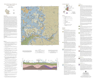
Bedrock Geology of Jefferson County, Wisconsin
Located in southeast Wisconsin, Jefferson County is almost entirely blanketed by sediments that were delivered or shaped by the ice sheet that covered this area during the last ice age. New mapping interprets the distribution of the bedrock surface that is buried beneath those glacial sediments as interpreted by three drill cores, over 13,000 well...-
GIS Data for the Bedrock Geology of Jefferson County, Wisconsin [dataset 1]
2024
GIS Data: GeMS file geodatabase, geopackage, shapefiles, metadata
-
Bedrock Elevation Raster for the Bedrock Geology of Jefferson County, Wisconsin [dataset 2]
2024
GIS Data: File geodatabase, metadata
-
Geochemical Data for the Bedrock Geology of Jefferson County, Wisconsin [dataset 3]
2024
Data: Excel spreadsheet
-
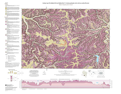
Geologic Map of the Highland West and Highland East 7.5-Minute Quadrangles, Grant and Iowa Counties, Wisconsin
The geologic map of the Highland West and Highland East 7.5-minute quadrangles includes 1:24,000-scale mapping of both surficial and bedrock geology. Highland was a long-lived and important sub-district of the Upper Mississippi lead-zinc mining area in the 19th and 20th centuries. Recent and renewed interest in the presence and distrubution of critical...-
Geologic Map of the Highland West and Highland East 7.5-Minute Quadrangles, Grant and Iowa Counties, Wisconsin
2024
Map: 46 in x 36 in, scale 1:24,000
-
GIS Data for the Geologic Map of the Highland West and Highland East 7.5-Minute Quadrangles, Grant and Iowa Counties, Wisconsin [dataset 1]
2024
GIS Data: GeMS file geodatabase, shapefiles, metadata
-
-
Quaternary Geology of Waupaca County, Wisconsin
The Quaternary geologic map of Waupaca County, Wisconsin, provides details about the surficial sediment and landscapes that were formed underneath and adjacent to the Laurentide Ice Sheet during the late Wisconsin Glaciation (ca. 20,000 years before present). These landscapes include lowlands underlain by glacial and postglacial lake sediment, uplands...-
Geologic Log Data for Quaternary Geology of Waupaca County, Wisconsin [dataset 1]
2023
Data: Excel spreadsheet
-
GIS Data for Quaternary Geology of Waupaca County, Wisconsin [dataset 2]
2023
GIS Data: GeMS file geodatabase, shapefiles, geopackage, metadata
-
Geologic Map of the North Freedom 7.5-Minute Quadrangle, Sauk County, Wisconsin
The North Freedom quadrangle is located on the South Range of the Baraboo Hills in south-central Wisconsin. The Baraboo Hills are recognized for their ecologic and geologic significance, with superb exposure of Precambrian and Paleozoic rocks and Quaternary sediments. Mapping focused on the Precambrian section, building on past work by subdividing and...-
Geologic Map of the North Freedom 7.5-Minute Quadrangle, Sauk County, Wisconsin
2020
Map: Scale 1:24,000, 40 in x 37 in
-
Geologic Map of the North Freedom 7.5-Minute Quadrangle, Sauk County, Wisconsin [GIS data]
2020
GIS Data: Geodatabase, metadata
-
-
Quaternary Geology of Oneida County, Wisconsin
Oneida County, in northern Wisconsin, is a mostly forested area dotted with lakes and wetlands. The watery landscape is a legacy of a time when glaciers flowed across the area. Geologists Attig and Rawling mapped the Quaternary geology of the county, documenting where the glaciers paused, the sediments that were deposited, and the landforms that were...-
Quaternary Geology of Oneida County, Wisconsin [GIS data]
2020
GIS Data: GeMS file geodatabase, metadata
-
Bedrock Geology of Fond du Lac County, Wisconsin
Two plates showing the bedrock geology and depth to bedrock in Fond du Lac County, Wisconsin. Includes GIS data (shapefiles and grid files).-
Bedrock Geology Map of Fond du Lac County, Wisconsin [plate 1]
2018
Plate: Scale 1:100,000, 35.75 in x 28.75 in
-
Depth to Bedrock Map of Fond du Lac County, Wisconsin [plate 2]
2018
Plate: Scale 1:100,000, 33 in x 19.25 in
-
Bedrock Geology of Wisconsin, West-Central Sheet
Types of bedrock, formation names, major faults, and time period of formation.-
Bedrock Geology of Wisconsin, West-Central Sheet [GIS data]
1988
GIS Data: GeMS file geodatabase and metadata
-
Bedrock Geology of Wisconsin, Northwest Sheet
Types of bedrock, formation names, major faults, and time period of formation.-
Bedrock Geology of Wisconsin, Northwest Sheet
1987
Map: 37.5 in x 22 in, scale 1:250,000 (map), 35.5 in x 20 in (explanation and cross sections)
-
-
Bedrock Geology of Wisconsin, Northeast Sheet
Types of bedrock, formation names, major faults, and time period of formation.-
Bedrock Geology of Wisconsin, Northeast Sheet [GIS data]
1984
GIS Data: GeMS file geodatabase and metadata
-
Bedrock Geologic Map of Wisconsin
Describes the types of rocks found throughout the state by age and explains how to interpret the accompanying cross section.

Publications Catalog
Wisconsin Geological and Natural History Survey