-
A Subsurface Study of the St. Peter Sandstone in Southern and Eastern Wisconsin
-
A Subsurface Study of the St. Peter Sandstone in Southern and Eastern Wisconsin
1985
Report: 26 p. + maps (scale 1:750,000)
-
-
Atlas of the Geological Survey of Wisconsin
Collection of most of the plates accompanying Chamberlin's four-volume Geology of Wisconsin: Survey of 1873-1879.-
Atlas of the Geological Survey of Wisconsin: General Geological Map of Wisconsin [plate 1]
1882
Map: Scale 1 in = 15 miles, 25.5 in x 30.3 in
-
Atlas of the Geological Survey of Wisconsin: General Map of Quaternary Formations [plate 2]
1882
Map: 28.2 in x 32.4 in
-
Atlas of the Geological Survey of Wisconsin: General Map of Native Vegetation [plate 2A]
1882
Map: 28.2 in x 32.4 in,
-
Atlas of the Geological Survey of Wisconsin: General Map of Soils [plate 2B]
1882
Map: 28.2 in x 32.5 in
-
Atlas of the Geological Survey of Wisconsin: Map of Rainfall and Temperature [plate 2C]
1882
Map: 27.7 in x 32.5 in
-
Atlas of the Geological Survey of Wisconsin: Maps of Subsoils and Native Vegetation of Eastern Wisconsin [plate 3]
1877
Map: 27.82 in x 32.17 in, scale 1 in = 12 miles
-
Atlas of the Geological Survey of Wisconsin: Maps of Topography and Quaternary Formations of Eastern Wisconsin [plate 4]
1877
Map: 27.83 in x 32.06 in, scale 1 in = 12 miles
-
Atlas of the Geological Survey of Wisconsin: Geology and Topography of the Lead Region [plate 5]
1877
Map: 27.68 in x 32.18 in
-
Atlas of the Geological Survey of Wisconsin: Geology and Topography of the Lead Region [plate 6]
1877
Map: 23.98 in x 28.94 in
-
Atlas of the Geological Survey of Wisconsin: Geology and Topography of the Lead Region [plate 8]
1877
Map: 24.03 in x 28.38 in
- 24 more...
-
-
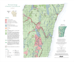
Pleistocene Geology of Kewaunee County, Wisconsin
Kewaunee County, at the southern end of the Door Peninsula, was overrun by glaciers many times. Author Lee Clayton describes the county's complex glacial geology, from the surface soil down to solid rock. The accompanying map shows the placement of glacial sediments as well as glacial and post-glacial stream and lake sediments.-
Pleistocene Geology of Kewaunee County, Wisconsin [plate 1]
2013
Map: Scale 1:100,000, 21.5 in x 18 in
-
Pleistocene Geology of the Door Peninsula
From Geological Society of American Bulletin, vol. 68, 1957.

Publications Catalog
Wisconsin Geological and Natural History Survey