-
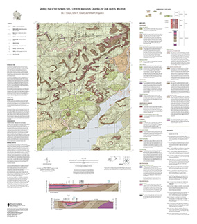
Geologic Map of the Durwards Glen 7.5-Minute Quadrangle, Columbia and Sauk Counties, Wisconsin
The Durwards Glen 7.5-minute quadrangle map is located in Columbia and Sauk counties, southeast of the city of Baraboo. This geologic map includes Precambrian through Quaternary units. New mapping has focused on subdividing the Baraboo Quartzite into four separate members and delineating Quaternary deposits in greater detail than prior work.-
Geologic Map of the Durwards Glen 7.5-Minute Quadrangle, Columbia and Sauk Counties, Wisconsin
2024
Map: 35 x 40 in, scale 1:24,000
-
GIS Data for the Geologic Map of the Durwards Glen 7.5-Minute Quadrangle, Columbia and Sauk Counties, Wisconsin [dataset 1]
2024
GIS Data: GeMS file geodatabase, shapefiles, geopackage, metadata
-
-
Geologic map of the Bloomington and Brodtville 7.5-minute quadrangles, Grant County, Wisconsin
The geologic map of the Bloomington and Brodtville quadrangles includes 1:24,000 scale mapping of both surficial and bedrock geology. There is little structural folding or faulting in this portion of the Driftless Area. Thus, it is ideal for studying the hydrostratigraphic framework of the mapped units. The accompanying report presents stratigraphic...-
Geologic map of the Bloomington and Brodtville 7.5-minute quadrangles, Grant County, Wisconsin
2022
Map: 41 in x 35 in, scale 1:24,000
-
GIS data for the geologic map of the Bloomington and Brodtville 7.5-minute quadrangles, Grant County, Wisconsin [dataset 1]
2022
GIS Data: File geodatabase
-
-
Geologic map of the Castle Rock and Long Hollow 7.5-minute quadrangles, Grant County, Wisconsin
The geologic map of the Castle Rock and Long Hollow quadrangles includes 1:24,000 scale mapping of both surficial and bedrock geology. The accompanying report presents new observations about bedrock folds and fracture sets in this portion of the Driftless Area that lies just north of the main Upper Mississippi Valley zinc-lead mineral district. The...-
Geologic map of the Castle Rock and Long Hollow 7.5-minute quadrangles, Grant County, Wisconsin (revised 2022)
2022
Map: 48 in x 36 in, scale 1:24,000
-
GIS data for the geologic map of the Castle Rock and Long Hollow 7.5-minute quadrangles, Grant County, Wisconsin [dataset 1]
2022
GIS Data: File geodatabase
-
-
Bedrock Geology of Dodge County, Wisconsin
Dodge County lies in southeast Wisconsin, an area almost entirely covered by glacial deposits. This map interprets the distribution of the buried bedrock units across the county. Geologist Esther Stewart’s refinement of the bedrock elevation contours may help land-use planners identify areas most susceptible to groundwater contamination from applications...-
Supporting Data for the Bedrock Geology of Dodge County, Wisconsin
2021
Data: Tabular data files (Excel)
-
GIS Data for the Bedrock Geology of Dodge County, Wisconsin [dataset 2]
2021
GIS Data: GeMS file geodatabase, shapefiles, GeoPackage, and metadata
-
Geologic Map of the North Freedom 7.5-Minute Quadrangle, Sauk County, Wisconsin
The North Freedom quadrangle is located on the South Range of the Baraboo Hills in south-central Wisconsin. The Baraboo Hills are recognized for their ecologic and geologic significance, with superb exposure of Precambrian and Paleozoic rocks and Quaternary sediments. Mapping focused on the Precambrian section, building on past work by subdividing and...-
Geologic Map of the North Freedom 7.5-Minute Quadrangle, Sauk County, Wisconsin
2020
Map: Scale 1:24,000, 40 in x 37 in
-
GIS Data for the Geologic Map of the North Freedom 7.5-Minute Quadrangle, Sauk County, Wisconsin (version 2) [dataset 1]
2020
GIS Data: GeMS file geodatabase, shapefiles, and metadata. Supersedes previous file geodatabase format (DI version 1)
-
-
Bedrock Geology of Fond du Lac County, Wisconsin
Two plates showing the bedrock geology and depth to bedrock in Fond du Lac County, Wisconsin. Includes GIS data (shapefiles and grid files).-
GIS Data for the Bedrock Geology of Fond du Lac County, Wisconsin (version 2) [dataset 1]
2018
GIS Data: GeMS file geodatabase, shapefiles, and metadata. Supersedes previous shapefile format (DI version 1)
-
Bedrock Geology Map of Fond du Lac County, Wisconsin [plate 1]
2018
Plate: Scale 1:100,000, 35.75 in x 28.75 in
-
Depth to Bedrock Map of Fond du Lac County, Wisconsin [plate 2]
2018
Plate: Scale 1:100,000, 33 in x 19.25 in
-
-
Preliminary Bedrock Geology of Dane County, Wisconsin
This map, produced at a scale of 1:100,000, reveals the intricate layers of bedrock below Dane County. Available as a map (plate 1), cross sections (plate 2), and GIS data. Open-file report; contains unpublished data that has not yet been peer-reviewed.-
Preliminary Bedrock Geology of Dane County, Wisconsin [plate 1]
2013
Map: 39 in x 25 in, scale 1:100,000
-
Bedrock Geology of Wisconsin, Northwest Sheet
Types of bedrock, formation names, major faults, and time period of formation.-
Bedrock Geology of Wisconsin, Northwest Sheet
1987
Map: 37.5 in x 22 in, scale 1:250,000 (map), 35.5 in x 20 in (explanation and cross sections)
-
-
Bedrock Geology of Wisconsin, Northeast Sheet
Types of bedrock, formation names, major faults, and time period of formation.-
Bedrock Geology of Wisconsin, Northeast Sheet [GIS data]
1984
GIS Data: GeMS file geodatabase and metadata
-
Bedrock Geologic Map of Wisconsin
Describes the types of rocks found throughout the state by age and explains how to interpret the accompanying cross section. -
Precambrian Geology of Marathon County, Wisconsin
-
GIS Data for the Precambrian Geology of Marathon County, Wisconsin (version 2) [dataset 1]
1983
GIS Data: GeMS file geodatabase, shapefiles, GeoPackage, and metadata. Supersedes previous shapefile format (DI version 1)

Publications Catalog
Wisconsin Geological and Natural History Survey