-
US Geological Survey Hydrologic Atlases
-
Water Resources of Wisconsin, Rock-Fox River Basin: Plate 1, Physical Setting, Water System
1969
Plate: 38 in x 27.25 in
-
Water Resources of Wisconsin, Rock-Fox River Basin: Plate 2, Surface Water
1969
Plate: 38 in x 27.25 in
-
Water Resources of Wisconsin, Rock-Fox River Basin: Plate 3, Ground Water
1969
Plate: 38 in x 27.25 in
-
-
Atlas of the Geological Survey of Wisconsin
Collection of most of the plates accompanying Chamberlin's four-volume Geology of Wisconsin: Survey of 1873-1879.-
Atlas of the Geological Survey of Wisconsin: General Geological Map of Wisconsin [plate 1]
1882
Map: Scale 1 in = 15 miles, 25.5 in x 30.3 in
-
Atlas of the Geological Survey of Wisconsin: General Map of Quaternary Formations [plate 2]
1882
Map: 28.2 in x 32.4 in
-
Atlas of the Geological Survey of Wisconsin: General Map of Native Vegetation [plate 2A]
1882
Map: 28.2 in x 32.4 in,
-
Atlas of the Geological Survey of Wisconsin: General Map of Soils [plate 2B]
1882
Map: 28.2 in x 32.5 in
-
Atlas of the Geological Survey of Wisconsin: Map of Rainfall and Temperature [plate 2C]
1882
Map: 27.7 in x 32.5 in
-
Atlas of the Geological Survey of Wisconsin: Maps of Subsoils and Native Vegetation of Eastern Wisconsin [plate 3]
1877
Map: 27.82 in x 32.17 in, scale 1 in = 12 miles
-
Atlas of the Geological Survey of Wisconsin: Maps of Topography and Quaternary Formations of Eastern Wisconsin [plate 4]
1877
Map: 27.83 in x 32.06 in, scale 1 in = 12 miles
-
Atlas of the Geological Survey of Wisconsin: Geology and Topography of the Lead Region [plate 5]
1877
Map: 27.68 in x 32.18 in
-
Atlas of the Geological Survey of Wisconsin: Geology and Topography of the Lead Region [plate 6]
1877
Map: 23.98 in x 28.94 in
-
Atlas of the Geological Survey of Wisconsin: Geology and Topography of the Lead Region [plate 8]
1877
Map: 24.03 in x 28.38 in
- 24 more...
-
-
Mechanisms of Groundwater Flow Across the Maquoketa Formation
Open-file report; contains unpublished data that has not yet been peer-reviewed. -
Pleistocene Geology of Southern Wisconsin
Field trip guide with special papers by R.F. Black, N.K. Bleuer, F.D. Hole, N.P. Lasca, and L.J. Maher, Jr., 1970, 175 p. -
Late Glacial History and Environmental Geology of Southeastern Wisconsin, Road Log and Geological Stop Descriptions
Companion volume to Geoscience Wisconsin, vol. 7. Prepared for 17th Annual Meeting of Geological Society of America. -
Groundwater Data Compilation for the Geneva Lake, Wisconsin, Area
Open-file report; contains unpublished data that has not yet been peer-reviewed.-
Regional Overview, Geneva Lake Area, Walworth County, Wisconsin [plate 1]
2006
Map: 11 in x 17 in, scale 1:100,000
-
Bedrock Geology, Geneva Lake Area, Walworth County, Wisconsin [plate 2]
2006
Map: 11 in x 17 in, scale 1:100,000
-
Elevation of Bedrock Surface, Geneva Lake Area, Walworth County, Wisconsin [plate 3]
2006
Map: 11 in x 17 in, scale 1:100,000
-
Depth to Bedrock (Thickness of Surficial Materials), Geneva Lake Area, Walworth County, Wisconsin [plate 4]
2006
Map: 11 in x 17 in, scale 1:100,000
-
Water Table Elevation, Geneva Lake Area, Walworth County, Wisconsin [plate 5]
2006
Map: 11 in x 17 in, scale 1:100,000
-
Publications by Other Contributors
-
Groundwater and Land Use in Water Cycle Poster - Placemat Size
Poster: 2 p., 16.75 in x 10.88 in
-
-
Geoscience Wisconsin Volume 18
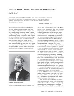
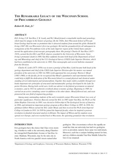
History of Wisconsin Geologists -
Wisconsin Groundwater-Level Monitoring Network Improvement
The Wisconsin Groundwater-Level Monitoring Network consists of 93 wells and 2 spring gaging stations. This report documents work performed on seven of the wells between August 1, 2016 and July 31, 2017, and appendices provide historical reference documents. -
Geoscience Wisconsin Volume 07
Late Pleistocene History of Southeastern Wisconsin-
Geoscience Wisconsin, Volume 7: Late Pleistocene History of Southeastern Wisconsin
1983
Journal: 111 p.
-

Publications Catalog
Wisconsin Geological and Natural History Survey