-
Geologic Map of the Fennimore and Mount Hope 7.5-Minute Quadrangles, Grant County, Wisconsin
The geologic map of the Fennimore and Mount Hope quadrangles includes 1:24,000-scale mapping of both surficial and bedrock geology. The mapping was initiated to support groundwater studies in the area. The map and accompanying report present the Paleozoic bedrock stratigraphy, including structures, as well as data from three new bedrock drill cores...-
Geologic Map of the Fennimore and Mount Hope 7.5-Minute Quadrangles, Grant County, Wisconsin
2023
Map: 50.55 x 36 in, scale 1:24,000
-
GIS Data for the Geologic Map of the Fennimore and Mount Hope 7.5-Minute Quadrangles, Grant County, Wisconsin [dataset 2]
2023
GIS Data: GeMS file geodatabase, metadata
-
-
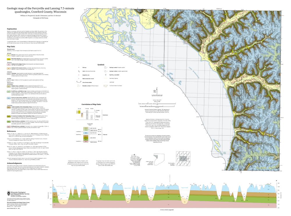
Geologic Map of the Ferryville and Lansing 7.5-Minute Quadrangles, Crawford County, Wisconsin
The geologic map of the Ferryville and Lansing 7.5-minute quadrangles (Crawford County), located in the Driftless Area of southwestern Wisconsin, provides new observations and lithologic descriptions of the area's geology. This work supports the Wisconsin Department of Transportation's ongoing efforts to mitigate slope failures along the Wisconsin State...-
Geologic Map of the Ferryville and Lansing 7.5-Minute Quadrangles, Crawford County, Wisconsin
2025
Map: 41.5 in x 30.75 in, scale 1:24,000
-
GIS Data for the Geologic Map of the Ferryville and Lansing 7.5-Minute Quadrangles, Crawford County, Wisconsin [dataset 1]
2025
GIS Data: GeMS Level 3 file geodatabase (.gdb file format) and GeoPackage (.gpkg file format)
-
-
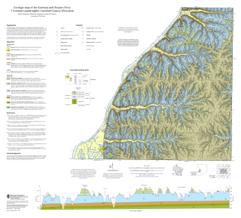
Geologic Map of the Eastman and Harpers Ferry 7.5-Minute Quadrangles, Crawford County, Wisconsin
The geologic map of the Eastman and Harpers Ferry 7.5-minute quadrangles (Crawford County), located in the Driftless Area of southwestern Wisconsin, provides new observations and lithologic descriptions of the area's geology. This work supports the Wisconsin Department of Transportation's ongoing efforts to mitigate slope failures along the Wisconsin...-
Geologic Map of the Eastman and Harpers Ferry 7.5-Minute Quadrangles, Crawford County, Wisconsin
2025
Map: 36 in x 32.5 in, scale 1:24,000
-
GIS Data for the Geologic Map of the Eastman and Harpers Ferry 7.5-Minute Quadrangles, Crawford County, Wisconsin [dataset 1]
2025
GIS Data: GeMS Level 3 file geodatabase (.gdb file format) and GeoPackage (.gpkg file format)
-
-
Bedrock Geology of Grant County, Wisconsin
Three-dimensional bedrock mapping of Grant County at a scale of 1:100,000 provides new baseline information on the distribution of geologic units. Grant County contains Paleozoic bedrock units ranging in age from Silurian to Cambrian. Gentle folds and small faults deform the Paleozoic sequence and were mapped based on structure contours of the base of the...-
GIS Data for Bedrock Geology of Grant County, Wisconsin [dataset 1]
2025
GIS Data: GeMS Level 3 file geodatabase (.gdb), GeoPackage, metadata
-
Geochemical Data for Bedrock Geology of Grant County, Wisconsin [dataset 2]
2025
Data: Spreadsheet (.csv)
-
GIS Data for Bedrock Geology of Grant County, Wisconsin [dataset 3]
2025
GIS Data: File geodatabase (.gdb) raster datasets, metadata

Publications Catalog
Wisconsin Geological and Natural History Survey