-
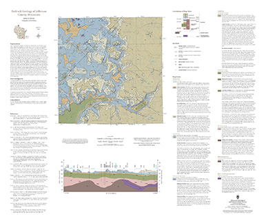
Bedrock Geology of Jefferson County, Wisconsin
Located in southeast Wisconsin, Jefferson County is almost entirely blanketed by sediments that were delivered or shaped by the ice sheet that covered this area during the last ice age. New mapping interprets the distribution of the bedrock surface that is buried beneath those glacial sediments as interpreted by three drill cores, over 13,000 well...-
GIS Data for the Bedrock Geology of Jefferson County, Wisconsin [dataset 1]
2024
GIS Data: GeMS file geodatabase, geopackage, shapefiles, metadata
-
Bedrock Elevation Raster for the Bedrock Geology of Jefferson County, Wisconsin [dataset 2]
2024
GIS Data: File geodatabase, metadata
-
Geochemical Data for the Bedrock Geology of Jefferson County, Wisconsin [dataset 3]
2024
Data: Excel spreadsheet
-
Geologic Map of the Durwards Glen 7.5-Minute Quadrangle, Columbia and Sauk Counties, Wisconsin
The Durwards Glen 7.5-minute quadrangle map is located in Columbia and Sauk counties, southeast of the city of Baraboo. This geologic map includes Precambrian through Quaternary units. New mapping has focused on subdividing the Baraboo Quartzite into four separate members and delineating Quaternary deposits in greater detail than prior work.-
Geologic Map of the Durwards Glen 7.5-Minute Quadrangle, Columbia and Sauk Counties, Wisconsin
2024
Map: 35 x 40 in, scale 1:24,000
-
GIS Data for the Geologic Map of the Durwards Glen 7.5-Minute Quadrangle, Columbia and Sauk Counties, Wisconsin [dataset 1]
2024
GIS Data: GeMS file geodatabase, shapefiles, geopackage, metadata
-
-
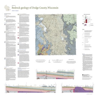
Bedrock Geology of Dodge County, Wisconsin
Dodge County lies in southeast Wisconsin, an area almost entirely covered by glacial deposits. This map interprets the distribution of the buried bedrock units across the county. Geologist Esther Stewart’s refinement of the bedrock elevation contours may help land-use planners identify areas most susceptible to groundwater contamination from applications...-
Supporting Data for the Bedrock Geology of Dodge County, Wisconsin
2021
Data: Tabular data files (Excel)
-
GIS Data for the Bedrock Geology of Dodge County, Wisconsin [dataset 2]
2021
GIS Data: GeMS file geodatabase, shapefiles, GeoPackage, and metadata
-
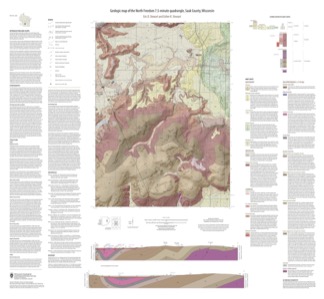
Geologic Map of the North Freedom 7.5-Minute Quadrangle, Sauk County, Wisconsin
The North Freedom quadrangle is located on the South Range of the Baraboo Hills in south-central Wisconsin. The Baraboo Hills are recognized for their ecologic and geologic significance, with superb exposure of Precambrian and Paleozoic rocks and Quaternary sediments. Mapping focused on the Precambrian section, building on past work by subdividing and...-
Geologic Map of the North Freedom 7.5-Minute Quadrangle, Sauk County, Wisconsin
2020
Map: 40 in x 37 in, scale 1:24,000
-
GIS Data for the Geologic Map of the North Freedom 7.5-Minute Quadrangle, Sauk County, Wisconsin (version 2) [dataset 1]
2020
GIS Data: GeMS file geodatabase, shapefiles, and metadata. Supersedes previous file geodatabase format (DI version 1)
-
-
Geology of the Baraboo Hills, Sauk and Columbia Counties, Wisconsin
Located in the south-central portion of the state, new geologic mapping of the frequently-visited Baraboo Hills has resulted in a revision of the stratigraphy of the Precambrian-aged bedrock. The Baraboo Quartzite is now divided into four informal members, and the maximum depositional age for the Baraboo Quartzite is 1714±17 million years old. These...-
Geology of the Baraboo Hills, Sauk and Columbia Counties, Wisconsin [plate 1]
2025
Map: 48.25 in x 29.25 in, scale 1:50,000
-
GIS Data for Geology of the Baraboo Hills, Sauk and Columbia Counties, Wisconsin [dataset 1]
2025
GIS Data: GeMS Level 3 file geodatabase (.gdb file format) and GeoPackage (.gpkg file fomat)

Publications Catalog
Wisconsin Geological and Natural History Survey