-
Wisconsin Groundwater-Level Monitoring Network Improvements, 2022-2024
This report documents work completed as part of a grant from the U.S. Geological Survey's National Groundwater Monitoring Network (NGWMN) program. It provides an overview of the Wisconsin Groundwater-Level Monitoring Network (WGLMN) and provides detailed description of well evaluation and repair activities, and drilling of new monitoring wells across the... -
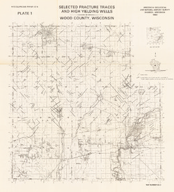
Irrigable Lands Inventory--Phase I Groundwater and Related Information
This paper contains hydrogeologic information for the Golden Sands Resource Conservation and Development Area in central Wisconsin. The set of maps includes water-table elevation maps for the following counties: Adams, Jackson, Juneau, Marathon, Marquette, Monroe, Portage, Waupaca, Waushara, and Wood (scale 1:126,720). It also includes a regional aquifer...-
Irrigable Lands Inventory - Phase I Groundwater and Related Information
1981
Report: 13 p. + 11 maps (scale 1:126,720 and 1:500,000)
- 2 more...
-
-
A Groundwater Flow Model for the Little Plover River Basin in Wisconsin's Central Sands
The bulletin describes the state-of-the-art scientific tool that can be used to help make good decisions about high-capacity well placement and pumping, as well as land use in Wisconsin's Central Sands region. It can also be used to predict which wells and well locations would have the greatest impact on nearby lakes and streams. The user's manual...-
A Groundwater Flow Model for the Little Plover River Basin in Wisconsin’s Central Sands [appendices]
2017
Data: PDFs + Excel files
-
Central Sands nitrate and neonicotinoids database
The Central Sands nitrate and neonicotinoid database consists of over 100,000 measurements of nitrate and neonicotinoid concentrations in groundwater from wells across Adams, Juneau, Marquette, Portage, Waushara, and Wood counties collected between 1953 and 2021. These counties comprise the Central Sands Groundwater County Collaborative (GSGCC), which... -
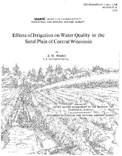
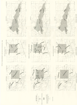
Effects of Irrigation on Water Quality in the Sand Plain of Central Wisconsin
-
Effects of Irrigation on Water Quality in the Sand Plain of Central Wisconsin
1978
Report: 50 p. + map (scale 1:24,000)
-
-
Central Sands Lakes Study: Annotated Bibliography
The authors of this open-file report scoured the literature for previous studies about the Central Sands area. This bibliography provides an overview of available research related to the hydrogeologic setting and water-budget components of the Central Sands Lakes Study (CSLS). -
Preliminary Report on the Soils and Agricultural Conditions of North Central Wisconsin
-
Preliminary Report on the Soils and Agricultural Conditions of North Central Wisconsin (2nd edition)
1903
Report: 72 p. + map (scale 1 in = 3 miles)
-
-
Water Resources of Wisconsin - Rock-Fox River Basin, Hydrologic Investigations Atlas HA-360
-
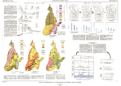
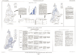
Water Resources of Wisconsin, Fox-Wolf River Basin: Plate 1, Physical Setting, Water System
1968
Plate: 38 in x 27.25 in
-
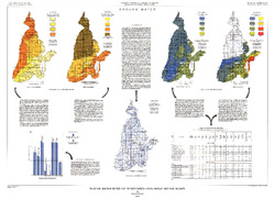
Water Resources of Wisconsin, Fox-Wolf River Basin: Plate 2, Ground Water
1968
Plate: 38 in x 27.25 in
-

Publications Catalog
Wisconsin Geological and Natural History Survey