-
Mechanisms of Groundwater Flow Across the Maquoketa Formation
Open-file report; contains unpublished data that has not yet been peer-reviewed. -
Ground-Water Resources and Geology of Washington and Ozaukee Counties, Wisconsin
-
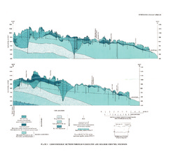
Ground-Water Resources and Geology of Washington and Ozaukee Counties, Wisconsin
1980
Report: 37 p. + map and cross sections (scale 1:125,000)
-
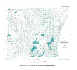
Water-Table Map of Washington and Ozaukee Counties, Wisconsin, Winter 1976-77
1980
Map: Scale 1:125,000
-
-
Groundwater Flow Model for the City of West Bend, Washington County, Wisconsin: Report to the City of West Bend, Wisconsin
Open-file report; contains unpublished data that has not yet been peer-reviewed. -
Depth to Silurian Bedrock in Eastern Wisconsin
Silurian-aged bedrock in eastern Wisconsin is shallow, fractured, and contains groundwater that is susceptible to surface water contamination. Revisions to Wisconsin state rules ATCP50 and NR151 to regulate manure spreading over this Silurian-aged bedrock create the need for a depth-to-bedrock map of eastern WI. The Wisconsin Geological and Natural...-
Depth to Silurian Bedrock in Eastern Wisconsin [dataset 1]
2025
GIS Data: File geodatabase, metadata
-
-
Merging Pleistocene Lithostratigraphy with Geotechnical and Hydrogeologic Data--Examples from Eastern Wisconsin
Open-file report; contains unpublished data that has not yet been peer-reviewed.

Publications Catalog
Wisconsin Geological and Natural History Survey