-
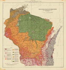
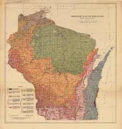
Bedrock Geologic Map of Wisconsin
Describes the types of rocks found throughout the state by age and explains how to interpret the accompanying cross section. -
Bedrock Geology of Dodge County, Wisconsin
Dodge County lies in southeast Wisconsin, an area almost entirely covered by glacial deposits. This map interprets the distribution of the buried bedrock units across the county. Geologist Esther Stewart’s refinement of the bedrock elevation contours may help land-use planners identify areas most susceptible to groundwater contamination from applications... -
Bedrock Geology of Wisconsin, Northeast Sheet
Types of bedrock, formation names, major faults, and time period of formation.-
Bedrock Geology of Wisconsin, Northeast Sheet [GIS data]
1984
GIS Data: GeMS file geodatabase and metadata
-
Preliminary Bedrock Geology of Dane County, Wisconsin
This map, produced at a scale of 1:100,000, reveals the intricate layers of bedrock below Dane County. Available as a map (plate 1), cross sections (plate 2), and GIS data. Open-file report; contains unpublished data that has not yet been peer-reviewed.-
Preliminary Bedrock Geology of Dane County, Wisconsin [plate 1]
2013
Map: 39 in x 25 in, scale 1:100,000
-
Bedrock Geology of Wisconsin, Northwest Sheet
Types of bedrock, formation names, major faults, and time period of formation.-
Bedrock Geology of Wisconsin, Northwest Sheet
1987
Map: 37.5 in x 22 in, scale 1:250,000 (map), 35.5 in x 20 in (explanation and cross sections)
-
-
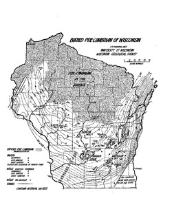
Contours on the Surface of the Precambrian Rocks in Dane County
Open-file report; contains unpublished data that has not yet been peer-reviewed. -
Geology of the Niagara-Aurora Area
Open-file report; contains unpublished data that has not yet been peer-reviewed.

Publications Catalog
Wisconsin Geological and Natural History Survey