-
Wisconsin Groundwater-Level Monitoring Network Improvements, 2018-2021
This report documents work completed as part of a grant from the U.S. Geological Survey’s National Groundwater Monitoring Network (NGWMN) program. It provides an overview of the Wisconsin Groundwater-Level Monitoring Network (WGLMN) and provides detailed description of well evaluation and repair activities, and drilling of new monitoring wells across the... -
Wisconsin Groundwater-Level Monitoring Network Improvement
The Wisconsin Groundwater-Level Monitoring Network consists of 93 wells and 2 spring gaging stations. This report documents work performed on seven of the wells between August 1, 2016 and July 31, 2017, and appendices provide historical reference documents. -
Groundwater Flow Model for the Geneva Lake Area, Walworth County, Wisconsin
Open-file report; contains unpublished data that has not yet been peer-reviewed. -
Mechanisms of Groundwater Flow Across the Maquoketa Formation
Open-file report; contains unpublished data that has not yet been peer-reviewed. -
Groundwater Data Compilation for the Geneva Lake, Wisconsin, Area
Open-file report; contains unpublished data that has not yet been peer-reviewed.-
Regional Overview, Geneva Lake Area, Walworth County, Wisconsin [plate 1]
2006
Map: 11 in x 17 in, scale 1:100,000
-
Bedrock Geology, Geneva Lake Area, Walworth County, Wisconsin [plate 2]
2006
Map: 11 in x 17 in, scale 1:100,000
-
Elevation of Bedrock Surface, Geneva Lake Area, Walworth County, Wisconsin [plate 3]
2006
Map: 11 in x 17 in, scale 1:100,000
-
Depth to Bedrock (Thickness of Surficial Materials), Geneva Lake Area, Walworth County, Wisconsin [plate 4]
2006
Map: 11 in x 17 in, scale 1:100,000
-
Water Table Elevation, Geneva Lake Area, Walworth County, Wisconsin [plate 5]
2006
Map: 11 in x 17 in, scale 1:100,000
-
The Waukesha Fault and its Relationship to the Michigan Basin: A Literature Compilation
Open-file report; contains unpublished data that has not yet been peer-reviewed. -
Report on the Preliminary Investigation of Arsenic in Groundwater near Lake Geneva, Wisconsin
Open-file report; contains unpublished data that has not yet been peer-reviewed.-
Report on the Preliminary Investigation of Arsenic in Groundwater Near Lake Geneva, Wisconsin
2000
Report: 19 p. + 5 color pages
-
-
Aggregate Resources of the Sinnipee Group in Eastern and Southern Wisconsin
Open-file report; contains unpublished data that has not yet been peer-reviewed. -
Merging Pleistocene Lithostratigraphy with Geotechnical and Hydrogeologic Data--Examples from Eastern Wisconsin
Open-file report; contains unpublished data that has not yet been peer-reviewed. -
A Subsurface Study of the St. Peter Sandstone in Southern and Eastern Wisconsin
-
A Subsurface Study of the St. Peter Sandstone in Southern and Eastern Wisconsin
1985
Report: 26 p. + maps (scale 1:750,000)
-
-
Ground-Water Resources and Geology of Walworth County, Wisconsin
-
Ground-Water Resources and Geology of Walworth County, Wisconsin
1976
Report: 45 p. + map (scale 1:125,000)
-
-
Pleistocene Geology of Southern Wisconsin
Field trip guide with special papers by R.F. Black, N.K. Bleuer, F.D. Hole, N.P. Lasca, and L.J. Maher, Jr., 1970, 175 p. -
Late Glacial History and Environmental Geology of Southeastern Wisconsin, Road Log and Geological Stop Descriptions
Companion volume to Geoscience Wisconsin, vol. 7. Prepared for 17th Annual Meeting of Geological Society of America. -
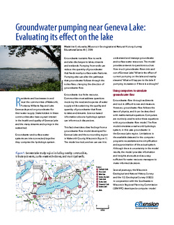
Groundwater Pumping Near Geneva Lake: Evaluating Its Effect on the Lake
A groundwater flow model developed for Geneva Lake and the surrounding region helps answer questions about flow into and out of the lake, and projects scenarios given increased pumping rates and potential long-term changes in climate.

Publications Catalog
Wisconsin Geological and Natural History Survey