-
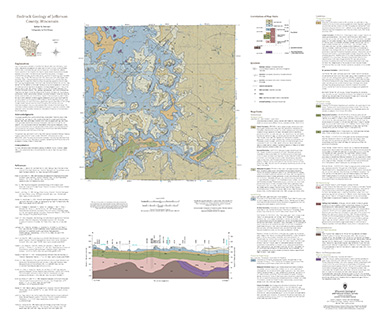
Bedrock Geology of Jefferson County, Wisconsin
Located in southeast Wisconsin, Jefferson County is almost entirely blanketed by sediments that were delivered or shaped by the ice sheet that covered this area during the last ice age. New mapping interprets the distribution of the bedrock surface that is buried beneath those glacial sediments as interpreted by three drill cores, over 13,000 well...-
GIS Data for the Bedrock Geology of Jefferson County, Wisconsin [dataset 1]
2024
GIS Data: GeMS file geodatabase, geopackage, shapefiles, metadata
-
Bedrock Elevation Raster for the Bedrock Geology of Jefferson County, Wisconsin [dataset 2]
2024
GIS Data: File geodatabase, metadata
-
Geochemical Data for the Bedrock Geology of Jefferson County, Wisconsin [dataset 3]
2024
Data: Excel spreadsheet
-
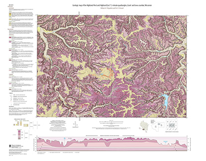
Geologic Map of the Highland West and Highland East 7.5-Minute Quadrangles, Grant and Iowa Counties, Wisconsin
The geologic map of the Highland West and Highland East 7.5-minute quadrangles includes 1:24,000-scale mapping of both surficial and bedrock geology. Highland was a long-lived and important sub-district of the Upper Mississippi lead-zinc mining area in the 19th and 20th centuries. Recent and renewed interest in the presence and distrubution of critical...-
Geologic Map of the Highland West and Highland East 7.5-Minute Quadrangles, Grant and Iowa Counties, Wisconsin
2024
Map: 46 in x 36 in, scale 1:24,000
-
GIS Data for the Geologic Map of the Highland West and Highland East 7.5-Minute Quadrangles, Grant and Iowa Counties, Wisconsin [dataset 1]
2024
GIS Data: GeMS file geodatabase, shapefiles, metadata
-
-
Geologic Map of the Fennimore and Mount Hope 7.5-Minute Quadrangles, Grant County, Wisconsin
The geologic map of the Fennimore and Mount Hope quadrangles includes 1:24,000-scale mapping of both surficial and bedrock geology. The mapping was initiated to support groundwater studies in the area. The map and accompanying report present the Paleozoic bedrock stratigraphy, including structures, as well as data from three new bedrock drill cores...-
Geologic Map of the Fennimore and Mount Hope 7.5-Minute Quadrangles, Grant County, Wisconsin
2023
Map: 50.55 x 36 in, scale 1:24,000
-
GIS Data for the Geologic Map of the Fennimore and Mount Hope 7.5-Minute Quadrangles, Grant County, Wisconsin [dataset 2]
2023
GIS Data: GeMS file geodatabase, metadata
-
-
Elevation contours of the Precambrian surface of south-central Wisconsin
Elevation contour data and an accompanying report provide an updated interpretation of the elevation of the top of Precambrian bedrock in south-central Wisconsin. The elevation surface was developed from geologic and geophysical data, and provides new detail on the entrenched bedrock valleys that were incised into the north and south ranges of the Baraboo...-
Elevation contours of the Precambrian surface of south-central Wisconsin [dataset 1]
2022
GIS Data: File geodatabase, metadata
-
-
Geologic map of the Bloomington and Brodtville 7.5-minute quadrangles, Grant County, Wisconsin
The geologic map of the Bloomington and Brodtville quadrangles includes 1:24,000 scale mapping of both surficial and bedrock geology. There is little structural folding or faulting in this portion of the Driftless Area. Thus, it is ideal for studying the hydrostratigraphic framework of the mapped units. The accompanying report presents stratigraphic...-
Geologic map of the Bloomington and Brodtville 7.5-minute quadrangles, Grant County, Wisconsin
2022
Map: 41 in x 35 in, scale 1:24,000
-
GIS data for the geologic map of the Bloomington and Brodtville 7.5-minute quadrangles, Grant County, Wisconsin [dataset 1]
2022
GIS Data: File geodatabase
-
-
Geologic map of the Castle Rock and Long Hollow 7.5-minute quadrangles, Grant County, Wisconsin
The geologic map of the Castle Rock and Long Hollow quadrangles includes 1:24,000 scale mapping of both surficial and bedrock geology. The accompanying report presents new observations about bedrock folds and fracture sets in this portion of the Driftless Area that lies just north of the main Upper Mississippi Valley zinc-lead mineral district. The...-
Geologic map of the Castle Rock and Long Hollow 7.5-minute quadrangles, Grant County, Wisconsin (revised 2022)
2022
Map: 48 in x 36 in, scale 1:24,000
-
GIS data for the geologic map of the Castle Rock and Long Hollow 7.5-minute quadrangles, Grant County, Wisconsin [dataset 1]
2022
GIS Data: File geodatabase
-
-
Hydrogeologic Atlas of Bayfield County, Wisconsin
Analysis of the groundwater resources in Bayfield County, Wisconsin. Includes report, five plates, and digital data.-
Generalized Water-Table Elevation Map of Bayfield County, Wisconsin [plate 1]
2019
Plate: 29.5 in x 39.5 in, scale 1:100,000
-
Depth to Water Table Map of Bayfield County, Wisconsin [plate 2]
2019
Plate: 29.5 in x 39.5 in, scale 1:100,000
-
Depth to Bedrock Map of Bayfield County, Wisconsin [plate 3]
2019
Plate: 29.5 in x 39.5 in, scale 1:100,000
-
Groundwater Recharge Map of Bayfield County, Wisconsin [plate 4]
2019
Plate: 29.5 in x 39.5 in, scale 1:100,000
-
Groundwater Susceptibility Map of Bayfield County, Wisconsin [plate 5]
2019
Plate: 29.5 in x 39.5 in, scale 1:100,000
-
Geology of Sauk County, Wisconsin
Geologic history and description of Sauk County, the home of Devils Lake and Parfreys Glen. Includes four-color bedrock map and cross sections. Map and cross sections are folded.-
Geology of Sauk County, Wisconsin
1990
Report: 68 p. + map (24.5 in x 34.5 in, scale 1:100,000) and Cross Sections (24 in x 38 in)
-
-
Geology of La Crosse County, Wisconsin
-
Geology of La Crosse County, Wisconsin
2003
Report: 33 p. + map and cross sections (scale 1:100,000)
-
Geology of La Crosse County, Wisconsin (version 2) [GIS Data]
2003
GIS Data: GeMS file geodatabase and metadata, supersedes previous coverage format (DI version 1)
-

Publications Catalog
Wisconsin Geological and Natural History Survey