-
Glacial and Related Deposits of Langlade County, Wisconsin
-
Glacial and Related Deposits of Langlade County, Wisconsin
1986
Report: 30 p. + map (scale 1:100,000)
-
Pleistocene Geology of Langlade County, Wisconsin (version 2) [GIS data]
1986
GIS Data: GeMS file geodatabase and metadata; supersedes previous coverage format
-
-
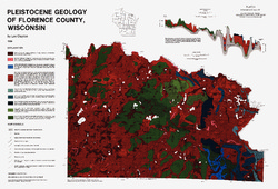
Pleistocene Geology of Florence County, Wisconsin
-
Pleistocene Geology of Florence County, Wisconsin (version 2) [GIS data]
1986
GIS Data: GeMS file geodatabase and metadata; supersedes previous coverage format
-
Pleistocene Geology of Vilas County, Wisconsin
-
Pleistocene Geology of Vilas County, Wisconsin (version 2) [GIS data]
1985
GIS Data: GeMS file geodatabase and metadata; supersedes previous coverage format
-
Pleistocene Geology of Brown County, Wisconsin
-
Pleistocene Geology of Brown County, Wisconsin
1985
Report: 19 p. + map of geology (scale 1:100,000)
-
-
A Subsurface Study of the St. Peter Sandstone in Southern and Eastern Wisconsin
-
A Subsurface Study of the St. Peter Sandstone in Southern and Eastern Wisconsin
1985
Report: 26 p. + maps (scale 1:750,000)
-
-
Pleistocene Geology of the Superior Region, Wisconsin
-
Pleistocene Geology of the Superior Region, Wisconsin [GIS data]
1985
GIS Data: GeMS file geodatabase, metadata
-
Pleistocene Geology of the Superior Region, Wisconsin [plate 1]
1985
Map: 36 in x 28 in, scale 1:250,000
-
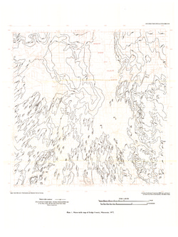
Ground-Water Resources and Geology of Dodge County, Wisconsin
-
Ground-Water Resources and Geology of Dodge County, Wisconsin
1983
Report: 34 p. + map (scale 1:125,000)
-
-
Ground-Water Quality of Rock County, Wisconsin
-
Ground-Water Quality of Rock County, Wisconsin
1982
Report: 92 p. + cross section and maps (scale 1:100,000)
-
Preliminary Map of the Thickness of Unconsolidated Material in Rock County, Wisconsin [plate 2]
1982
Map: Scale 1:100,000
-
-
Ground-Water Resources and Geology of Washington and Ozaukee Counties, Wisconsin
-
Ground-Water Resources and Geology of Washington and Ozaukee Counties, Wisconsin
1980
Report: 37 p. + map and cross sections (scale 1:125,000)
-
Water-Table Map of Washington and Ozaukee Counties, Wisconsin, Winter 1976-77
1980
Map: Scale 1:125,000
-
-
Effects of Irrigation on Water Quality in the Sand Plain of Central Wisconsin
-
Effects of Irrigation on Water Quality in the Sand Plain of Central Wisconsin
1978
Report: 50 p. + map (scale 1:24,000)
-
-
Ground-Water Resources and Geology of Walworth County, Wisconsin
-
Ground-Water Resources and Geology of Walworth County, Wisconsin
1976
Report: 45 p. + map (scale 1:125,000)
-
-
Ground-Water Resources and Geology of Jefferson County, Wisconsin
-
Ground-Water Resources and Geology of Jefferson County, Wisconsin
1976
Report: 31 p. + map (scale 1 in = 2 miles)
-

Publications Catalog
Wisconsin Geological and Natural History Survey