-
2018 Year in Review
An overview of some of the projects worked on by the Wisconsin Geological and Natural History Survey in 2018. -
2017 Year in Review
In 2017, Survey staff worked in 69 Wisconsin counties. We mapped geology, inventoried springs, and created groundwater models. We provide natural resource managers – land and water conservationists, county boards, and water utilities – with the information they need to protect and share their resources. This publication provides a summary of some of the... -
Laurentide Ice Sheet: Ice-Margin Positions in Wisconsin
Series of 43 page-size maps showing the chronology of the last glaciation's advances and retreats across Wisconsin. Includes a brief discussion about how the maps were made, how lake positions were determined, as well as a list of selected references. -
Lexicon of Pleistocene Stratigraphic Units of Wisconsin
This 180-page book marks the first update in over 20 years to the collection of formal definitions of Wisconsin's Pleistocene units. Contains over 100 color maps, photographs, and figures as well as an extensive list of references. -
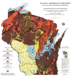
Glacial Deposits of Wisconsin: Sand and Gravel Resource Potential
Color map showing outwash, ground moraine, end moraine, and glacial deposits.-
Glacial Deposits of Wisconsin: Sand and Gravel Resource Potential
1976
Map: 45 in x 43.25 in, scale 1:500,000
-
-
Glaciation of Wisconsin
Brief technical description of Wisconsin’s geologic history, glacial phases and lobes, and correlation and distribution of Pleistocene units. Heavily illustrated. -
The Clays and Clay Industries of Wisconsin
Bulletin is titled Part 1; however, Part 2 was never published.

Publications Catalog
Wisconsin Geological and Natural History Survey