-
Original Vegetation Cover of Wisconsin
Based on the original land-survey records compiled between 1832 and 1866. Also available as set with Wisconsin Land Cover map. -
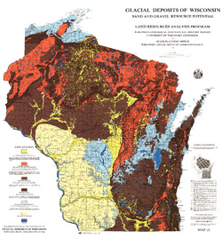
Glacial Deposits of Wisconsin: Sand and Gravel Resource Potential
Color map showing outwash, ground moraine, end moraine, and glacial deposits.-
Glacial Deposits of Wisconsin: Sand and Gravel Resource Potential
1976
Map: 45 in x 43.25 in, scale 1:500,000
-
-
Ground-Water Resources and Geology of Walworth County, Wisconsin
-
Ground-Water Resources and Geology of Walworth County, Wisconsin
1976
Report: 45 p. + map (scale 1:125,000)
-
-
Ground-Water Resources and Geology of Jefferson County, Wisconsin
-
Ground-Water Resources and Geology of Jefferson County, Wisconsin
1976
Report: 31 p. + map (scale 1 in = 2 miles)
-
-
Ground-Water Resources and Geology of St. Croix County, Wisconsin
-
Ground-Water Resources and Geology of St. Croix County, Wisconsin
1976
Report: 30 p. + map (scale 1:125,000)
-
-
Soils of Wisconsin
A comprehensive summary of the soil resources of the state. Includes definitions of terms and concepts relating to the processes of soil formation, soil properties, soil classification, and descriptions of major soil regions and of the specific kinds of soils that characterize them. -
Mineral and Water Resources of Wisconsin
Report prepared by the U.S. Geological Survey in collaboration with the Wisconsin Geological and Natural History Survey. Printed at the request of Committee on Interior and Insular Affairs, U.S. Senate.

Publications Catalog
Wisconsin Geological and Natural History Survey