-
3-D Wisconsin
When viewed with 3-D glasses, Wisconsin’s land features pop off the page. Brief descriptions of major land forms paint the geologic history that shaped the state; expanded descriptions and photos are online. We’ve field-tested this map on fourth graders and can attest to its appeal. Sizes: 27.5 x 32 inches, 8.5 x 11 inches. Requires red-blue 3-D glasses. -
Depth to Bedrock Map of Iowa County, Wisconsin
Open-file report; contains unpublished data that has not yet been peer-reviewed. -
Groundwater Data Compilation for the Geneva Lake, Wisconsin, Area
Open-file report; contains unpublished data that has not yet been peer-reviewed.-
Regional Overview, Geneva Lake Area, Walworth County, Wisconsin [plate 1]
2006
Map: 11 in x 17 in, scale 1:100,000
-
Bedrock Geology, Geneva Lake Area, Walworth County, Wisconsin [plate 2]
2006
Map: 11 in x 17 in, scale 1:100,000
-
Elevation of Bedrock Surface, Geneva Lake Area, Walworth County, Wisconsin [plate 3]
2006
Map: 11 in x 17 in, scale 1:100,000
-
Depth to Bedrock (Thickness of Surficial Materials), Geneva Lake Area, Walworth County, Wisconsin [plate 4]
2006
Map: 11 in x 17 in, scale 1:100,000
-
Water Table Elevation, Geneva Lake Area, Walworth County, Wisconsin [plate 5]
2006
Map: 11 in x 17 in, scale 1:100,000
-
Preliminary Bedrock Topography Map of Walworth, Racine, Kenosha, Milwaukee, Waukesha, Ozaukee, and Washington Counties
Open-file report; contains unpublished data that has not yet been peer-reviewed.-
Preliminary Bedrock Topography Map of Walworth, Racine, Kenosha, Milwaukee, Waukesha, Ozaukee, and Washington Counties
2004
Map: 34.75 in x 52 in, scale 1:100,000
-
-
Preliminary Bedrock Geology of Washington County, Wisconsin
Open-file report; contains unpublished data that has not yet been peer-reviewed.-
Preliminary Bedrock Geologic Map of Washington County, Wisconsin
2004
Map: 19 in x 17 in, scale 1:100,000
-
Preliminary Bedrock Topography Map of Washington County, Wisconsin
2004
Map: 19 in x 17 in,scale 1:100,000
-
Preliminary Depth to Bedrock Map of Washington County, Wisconsin
2004
Map: 19 in x 17 in, scale 1:100,000
-
-
Preliminary Bedrock Geology of Ozaukee County, Wisconsin
Open-file report; contains unpublished data that has not yet been peer-reviewed.-
Preliminary Bedrock Geologic Map of Ozaukee County, Wisconsin
2004
Map: 15 in x 17 in, scale 1:100,000
-
Preliminary Bedrock Topography Map of Ozaukee County, Wisconsin
2004
Map: 15 in x 17 in, scale 1:100,000
-
Preliminary Depth to Bedrock Map of Ozaukee County, Wisconsin
2004
Map: 15 in x 17 in, scale 1:100,000
-
-
Preliminary Bedrock Geology of Waukesha County, Wisconsin
Open-file report; contains unpublished data that has not yet been peer-reviewed.-
Preliminary Bedrock Geologic Map of Waukesha County, Wisconsin
2004
Map: 17.75 in x 23 in, scale 1:100,000
-
Preliminary Bedrock Topography Map of Waukesha County, Wisconsin
2004
Map: 17.75 in x 23 in, scale 1:100,000
-
Preliminary Depth to Bedrock Map of Waukesha County, Wisconsin
2004
Map: 17.75 in x 23 in, scale 1:100,000
-
-
Preliminary Bedrock Geology of Milwaukee County, Wisconsin
Open-file report; contains unpublished data that has not yet been peer-reviewed.-
Preliminary Bedrock Geologic Map of Milwaukee County, Wisconsin
2004
Map: 14 in x 17 in, scale 1:100,000
-
Preliminary Bedrock Topography Map of Milwaukee County, Wisconsin
2004
Map: 14 in x 17 in, scale 1:100,000
-
Preliminary Depth to Bedrock Map of Milwaukee County, Wisconsin
2004
Map: 14 in x 17 in, scale 1:100,000
-
-
Preliminary Bedrock Geology of Kenosha County, Wisconsin
Open-file report; contains unpublished data that has not yet been peer-reviewed.-
Preliminary Bedrock Geologic Map of Kenosha County, Wisconsin
2004
Map: 18 in x 14 in, scale 1:100,000
-
Preliminary Bedrock Topography Map of Kenosha County, Wisconsin
2004
Map: 18 in x 14 in, scale 1:100,000
-
Preliminary Depth to Bedrock Map of Kenosha County, Wisconsin
2004
Map: 18 in x 14 in, scale 1:100,000
-
-
Preliminary Bedrock Geology of Racine County, Wisconsin
Open-file report; contains unpublished data that has not yet been peer-reviewed.-
Preliminary Bedrock Geologic Map of Racine County, Wisconsin
2004
Map: 19 in x 15 in, scale 1:100,000
-
Preliminary Bedrock Topography Map of Racine County, Wisconsin
2004
Map: 19 in x 15 in, scale 1:100,000
-
Preliminary Depth to Bedrock Map of Racine County, Wisconsin
2004
Map: 19 in x 15 in, scale 1:100,000
-
-
Preliminary Bedrock Geology of Walworth County, Wisconsin
Open-file report; contains unpublished data that has not yet been peer-reviewed.-
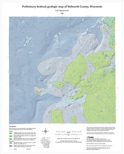
Preliminary Bedrock Geologic Map of Walworth County, Wisconsin
2004
Map: 17.75 in x 22 in, scale 1:100,000
-
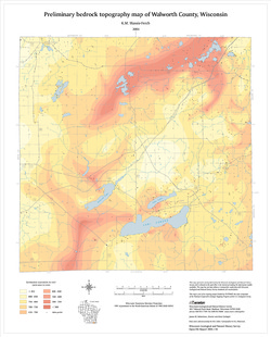
Preliminary Bedrock Topography Map of Walworth County, Wisconsin
2004
Map: 17.75 in x 22 in, scale 1:100,000
-
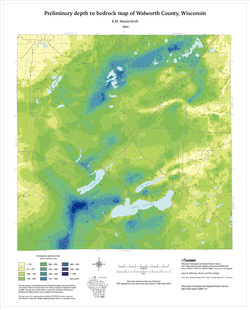
Preliminary Depth to Bedrock Map of Walworth County, Wisconsin
2004
Map: 17.75 in x 22 in, scale 1:100,000
-
-
Shaded Relief Map of Sauk County, Wisconsin
Open-file report; contains unpublished data that has not yet been peer-reviewed. -
Contours on the Surface of the Precambrian Rocks in Dane County
Open-file report; contains unpublished data that has not yet been peer-reviewed. -
Contours on the Base of the Eau Claire Sandstone in Dane County
Open-file report; contains unpublished data that has not yet been peer-reviewed. -
Contours on the Base of the Tunnel City Formation in Dane County
Open-file report; contains unpublished data that has not yet been peer-reviewed. -
Bedrock Topography of Dane County
Open-file report; contains unpublished data that has not yet been peer-reviewed. -
Land Surface Topography of Dane County
Open-file report; contains unpublished data that has not yet been peer-reviewed. -
Dane County, Wisconsin (Base Map)
Open-file report; contains unpublished data that has not yet been peer-reviewed. -
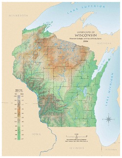
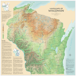
Landscapes of Wisconsin
Shows the elevation of Wisconsin through the use of color and shaded relief. Includes explanatory text about the geologic history of the state and more detailed information about 12 of the most prominent features. Poster map scale 1:500,000. Size: 42 x 42 inches.

Publications Catalog
Wisconsin Geological and Natural History Survey