-
Slope Stability, Douglas County Red Clay District, Wisconsin
Open-file report; contains unpublished data that has not yet been peer-reviewed. -
Contours on the Surface of the Precambrian Rocks in Dane County
Open-file report; contains unpublished data that has not yet been peer-reviewed. -
Contours on the Base of the Eau Claire Sandstone in Dane County
Open-file report; contains unpublished data that has not yet been peer-reviewed. -
Contours on the Base of the Tunnel City Formation in Dane County
Open-file report; contains unpublished data that has not yet been peer-reviewed. -
Bedrock Topography of Dane County
Open-file report; contains unpublished data that has not yet been peer-reviewed. -
Land Surface Topography of Dane County
Open-file report; contains unpublished data that has not yet been peer-reviewed. -
Dane County, Wisconsin (Base Map)
Open-file report; contains unpublished data that has not yet been peer-reviewed. -
Hamilton Mounds in Adams County, Wisconsin
Open-file report; contains unpublished data that has not yet been peer-reviewed. -
The Need for Completing Our Wisconsin Topographic Mapping
Open-file report; contains unpublished data that has not yet been peer-reviewed. -
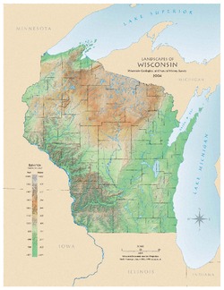
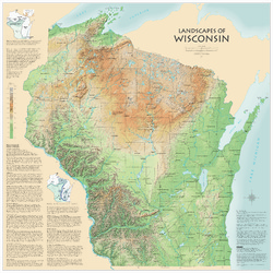
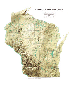
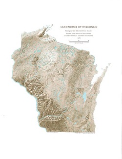
Landscapes of Wisconsin
Shows the elevation of Wisconsin through the use of color and shaded relief. Includes explanatory text about the geologic history of the state and more detailed information about 12 of the most prominent features. Poster map scale 1:500,000. Size: 42 x 42 inches. -
Atlas of Groundwater Resources and Geology of Barron County, Wisconsin
Includes Physical Setting; Soils of Barron County and Their Ability to Attenuate Pollutants; Bedrock Geology; Depth to Bedrock; Hydrogeology; Water Quality; Potential Sources of Groundwater Pollution; Groundwater Levels; Groundwater Pollution Potential.-
Atlas of Groundwater Resources and Geology of Barron County, Wisconsin: Soils of Barron County and Their Ability to Attenuate Pollutants
1987
Map: 30.8 in x 20.8 in, scale 1:100,000
-
Atlas of Groundwater Resources and Geology of Barron County, Wisconsin: Bedrock Geology of Barron County, Wisconsin
1987
Map: 21.5 in x 28.5 in, scale 1:250,000
-
Atlas of Groundwater Resources and Geology of Barron County, Wisconsin: Depth to Bedrock in Barron County, Wisconsin
1987
Map: 21.1 in x 27.6 in, scale 1:100,000
-
Atlas of Groundwater Resources and Geology of Barron County, Wisconsin: Hydrogeology of Barron County, Wisconsin
1987
Map: 37.5 in x 24.5 in, scale 1:100,000
-
Atlas of Groundwater Resources and Geology of Barron County, Wisconsin: Potential Sources of Groundwater Pollution in Barron County, Wisconsin
1987
Map: 35.75 in x 23.3 in, scale 1:100,000
-
Atlas of Groundwater Resources and Geology of Barron County, Wisconsin: Groundwater Levels in Barron County, Wisconsin
1987
Map: 35.8 in x 23.3 in, scale 1:100,000
-
Atlas of Groundwater Resources and Geology of Barron County, Wisconsin: Groundwater Pollution Potential of Barron County, Wisconsin
1987
Map: 36.7 in x 24.25 in, scale 1:100,000

Publications Catalog
Wisconsin Geological and Natural History Survey