-
Erosion Hazard Areas: An Alternative for Shore Management
Open-file report; contains unpublished data that has not yet been peer-reviewed. -
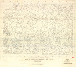
Analysis of Clam Lake Gravity and Magnetic Anomalies
Open-file report; contains unpublished data that has not yet been peer-reviewed. -
Chemical Analyses of Wisconsin Clays and Shales from Publications and Files of the Wisconsin Geological and Natural History Survey
Open-file report; contains unpublished data that has not yet been peer-reviewed. -
Annotated Bibliography of Geological, Hydrologic, Soils, and Climatologic Information for Wisconsin's Great Lakes Coastal Zone Counties
Open-file report; contains unpublished data that has not yet been peer-reviewed. -
Maps Prepared as Overlays for Proposed Golf Course and Facilities North of Verona
Open-file report; contains unpublished data that has not yet been peer-reviewed. See WOFR1974-03 for companion report.-
Maps Prepared as Overlays for Proposed Golf Course and Facilities North of Verona
1975
Plate: 1 p. + 23 plates (1:24,000 scale)
-
-
Stability of Rock Masses on East Side of Rocky Gorge, Manitou Falls Area, Pattison State Park
Open-file report; contains unpublished data that has not yet been peer-reviewed. -
A Report on Soil Association Suitabilities to the State Planning Office, Wisconsin Department of Adminstration
Open-file report; contains unpublished data that has not yet been peer-reviewed. -
Shoreline Erosion in Southeastern Wisconsin
Open-file report; contains unpublished data that has not yet been peer-reviewed. -
Slope Stability, Douglas County Red Clay District, Wisconsin
Open-file report; contains unpublished data that has not yet been peer-reviewed. -
Land Use and the Geologic and Hydrologic Environment in Burke Township, Dane County, Wisconsin
Open-file report; contains unpublished data that has not yet been peer-reviewed.-
Land Use and the Geologic and Hydrologic Environment in Burke Township, Dane County, Wisconsin
1974
Report: 66 p. + 23 plates
-
-
A Geological Reconnaissance of Bender County Park, Milwaukee County, Wisconsin
Open-file report; contains unpublished data that has not yet been peer-reviewed. -
Land Use and the Geologic and Hydrologic Environment in Parts of Middleton, Verona, Madison, and Fitchburg Townships, Dane County, Wisconsin
Open-file report; contains unpublished data that has not yet been peer-reviewed. See WOFR1975-02 for companion plates. -
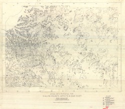
Areas with Potential for Shallow Dolomite Deposits in Dane County
Open-file report; contains unpublished data that has not yet been peer-reviewed.-
Areas with Potential for Shallow Dolomite Deposits in Dane County
1974
Map: 47.4 in x 41.1 in, scale 1:62,500
-
-
Areas with Potential for Shallow Sandstone Deposits in Dane County
Open-file report; contains unpublished data that has not yet been peer-reviewed.-
Areas with Potential for Shallow Sandstone Deposits in Dane County
1974
Map: 45.8 in x 40.3 in, scale 1:62,500
-
-
The Geological Environment of the Superior Area, Douglas County, Wisconsin
Open-file report; contains unpublished data that has not yet been peer-reviewed.-
The Geological Environment of the Superior Area, Douglas County, Wisconsin
1973
Report: 119 p. + 4 plates
-
-
Surficial Materials Map, Waukesha County
Open-file report; contains unpublished data that has not yet been peer-reviewed.-
Explanation for 1:24,000 Surficial Materials Maps of Dane and Waukesha Counties
1973
Report: 12 p. + 1 plate
-
-
Guide to the Study of Water Movement in Soil Pedons Above the Water Table
Open-file report; contains unpublished data that has not yet been peer-reviewed. -
Elevation of the Water Table and Areas of Shallow Groundwater of Dane County
Open-file report; contains unpublished data that has not yet been peer-reviewed.-
Elevation of the Watertable and Areas of Shallow Groundwater of Dane County
1973
Map: 46.3 in x 40.5 in, scale 1:62,500
-
-
Thickness of Unconsolidated Deposits and Areas of Shallow Bedrock in Dane County
Open-file report; contains unpublished data that has not yet been peer-reviewed.-
Thickness of Unconsolidated Deposits and Areas of Shallow Bedrock in Dane County (revised 1993)
1973
Map: 49.5 in x 36 in, scale 1:62,500
-
-
Surficial Materials of Dane County
Open-file report; contains unpublished data that has not yet been peer-reviewed.

Publications Catalog
Wisconsin Geological and Natural History Survey