-
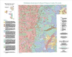
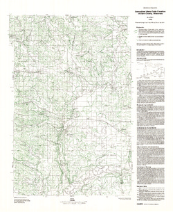
Preliminary Quaternary Geology of Waupaca County, Wisconsin
This open-file report contains a map (PDF) and GIS data (shapefiles) of the glacial and post-glacial deposits of Waupaca County in central Wisconsin. This map and GIS data were superseded by a Map Series publication in 2023: https://doi.org/10.54915/bger3320.-
Preliminary Quaternary Geology of Waupaca County, Wisconsin [plate 1]
2015
Map: 29 in x 23 in, scale 1:100,000
-
Preliminary Quaternary Geology of Waupaca County, Wisconsin [GIS data]
2015
GIS Data: Shapefiles (.shp file format)
-
-
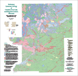
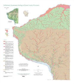
Preliminary Quaternary Geology of Columbia, Green Lake, and Marquette Counties, Wisconsin
This open-file report contains a map (PDF), GIS data (shapefiles), and metadata for Columbia, Green Lake, and Marquette Counties in central Wisconsin.-
Preliminary Quaternary Geology of Columbia, Green Lake, and Marquette Counties, Wisconsin [plate 1]
2015
Map: 35 in x 34 in, scale 1:100,000
-
Preliminary Quaternary Geology of Columbia, Green Lake, and Marquette Counties, Wisconsin [GIS data]
2015
GIS Data: Shapefiles (.shp file format)
-
-
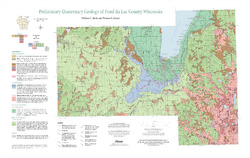
Preliminary Quaternary Geology of Fond du Lac County, Wisconsin
Open-file report-
Preliminary Quaternary Geology of Fond du Lac County, Wisconsin [plate 1]
2014
Map: 32 in x 20.25 in, scale 1:100,000
-
Preliminary Quaternary Geology of Fond du Lac County, Wisconsin [GIS data]
2014
GIS Data: Shapefiles (.shp file format)
-
-
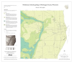
Preliminary Bedrock Geology of Sheboygan County, Wisconsin
Open-file report; contains unpublished data that has not yet been peer-reviewed.-
Preliminary Bedrock Geology of Sheboygan County, Wisconsin (version 2) [GIS data]
2013
GIS Data: GeMS file geodatabase (.gdb file format)
-
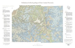
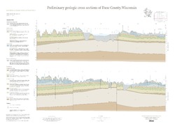
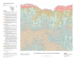
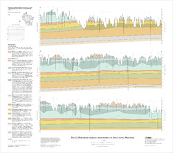
Preliminary Bedrock Geology of Dane County, Wisconsin
This map, produced at a scale of 1:100,000, reveals the intricate layers of bedrock below Dane County. Available as a map (plate 1), cross sections (plate 2), and GIS data. Open-file report; contains unpublished data that has not yet been peer-reviewed.-
Preliminary Bedrock Geology of Dane County, Wisconsin [plate 1]
2013
Map: 39 in x 25 in, scale 1:100,000
-
Preliminary Bedrock Geology of Dane County, Wisconsin [GIS data]
2013
GIS Data: Documents (.pdf file format), shapefiles (.shp file format)
-
-
Preliminary Quaternary Geology of Grant County, Wisconsin
Open-file report; contains unpublished data that has not yet been peer-reviewed.-
Preliminary Quaternary Geology of Grant County, Wisconsin [GIS data]
2012
GIS Data: Shapefiles (.shp file format)
-
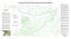
Preliminary Water-Table Elevation Map of Columbia County, Wisconsin
Open-file report; contains unpublished data that has not yet been peer-reviewed.-
Preliminary Water-Table Elevation Map of Columbia County, Wisconsin
2012
Map: 36 in x 20 in, scale 1:100,000
-
Preliminary Water-Table Elevation Map of Columbia County, Wisconsin [GIS data]
2012
GIS Data: Shapefiles (.shp file format)
-
-
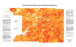
Groundwater Susceptibility Map of Columbia County, Wisconsin
Open-file report; contains unpublished data that has not yet been peer-reviewed.-
Groundwater Susceptibility Map of Columbia County, Wisconsin
2012
Map: 34.5 in x 20.5 in, scale 1:100,000
-
Groundwater Susceptibility Map of Columbia County, Wisconsin [GIS data]
2012
GIS Data: Layer files (.lyr file format), Esri grid files
-
-
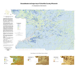
Groundwater Recharge Map of Columbia County, Wisconsin
Open-file report; contains unpublished data that has not yet been peer-reviewed.-
Groundwater Recharge Map of Columbia County, Wisconsin [GIS data]
2012
GIS Data: Layer files (.lyr file format), Esri grid files
-
Preliminary Geology of Iowa County, Wisconsin
Open-file report; contains unpublished data that has not yet been peer-reviewed.-
Preliminary Bedrock Geology of Iowa County, Wisconsin (version 2) [GIS data]
2010
GIS Data: GeMS file geodatabase (.gdb file format)
-
Preliminary Geologic Map of Iowa County, Wisconsin [plate 1]
2010
Map: 28 in x 22 in, scale 1:100,000
-
-
Assessing the Ecological Status and Vulnerability of Springs in Wisconsin
Open-file report; contains unpublished data that has not yet been peer-reviewed.-
Assessing the Ecological Status and Vulnerability of Springs in Wisconsin [GIS Data]
2008
GIS Data: Shapefiles (.shp file format), images (.jpeg file format), Microsoft Access database (.mdb file format)
-
Inventory of Wisconsin's Springs
Open-file report; contains unpublished data that has not yet been peer-reviewed.-
Inventory of Wisconsin's Springs [GIS data]
2007
GIS Data: Shapefiles (.shp file format), databases (.dbf file format)
-
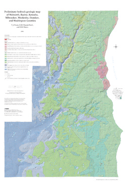
Preliminary Bedrock Geologic Map of Walworth, Racine, Kenosha, Milwaukee, Waukesha, Ozaukee, and Washington Counties
Open-file report; contains unpublished data that has not yet been peer-reviewed.-
Preliminary Bedrock Geologic Map of Walworth, Racine, Kenosha, Milwaukee, Waukesha, Ozaukee, and Washington Counties
2004
Map: 34.75 in x 52 in, scale 1:100,000
-
Preliminary Bedrock Geologic Map of Walworth, Racine, Kenosha, Milwaukee, Waukesha, Ozaukee, and Washington Counties [GIS data]
2004
GIS Data: GeMS file geodatabase (.gdb file format)
-
-
Bedrock Geology of Wisconsin, West-Central Sheet
Types of bedrock, formation names, major faults, and time period of formation.-
Bedrock Geology of Wisconsin, West-Central Sheet [GIS data]
1988
GIS Data: GeMS file geodatabase (.gdb file format)
-
Generalized Water-Table Elevation of Dunn County, Wisconsin
-
Generalized Water-Table Elevation of Dunn County, Wisconsin
1988
Map: 22.3 in x 27.2 in, scale 1:100,000
-
GIS Data for the Generalized Water-Table Elevation of Dunn County, Wisconsin [dataset 1]
1988
GIS Data: File geodatabase (.gdb file format)
-
-
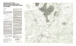
Generalized Water-Table Elevation of Chippewa County, Wisconsin
-
Generalized Water-Table Elevation of Chippewa County, Wisconsin
1988
Map: 36 in x 22 in, scale 1:100,000
-
GIS Data for the Generalized Water-Table Elevation of Chippewa County, Wisconsin [dataset 1]
1988
GIS Data: File geodatabase (.gdb file format)
-
-
Bedrock Geology of Wisconsin, Northwest Sheet
Types of bedrock, formation names, major faults, and time period of formation.-
Bedrock Geology of Wisconsin, Northwest Sheet
1987
Map: 37.5 in x 22 in, scale 1:250,000; 35.5 in x 20 in
-
Bedrock Geology of Wisconsin, Northwest Sheet [GIS data]
1987
GIS Data: MrSID files (.sid file format)
-
-
Bedrock Geology of Wisconsin, Northeast Sheet
Types of bedrock, formation names, major faults, and time period of formation.-
Bedrock Geology of Wisconsin, Northeast Sheet [GIS data]
1984
GIS Data: GeMS file geodatabase (.gdb file format)
-
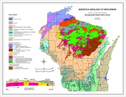
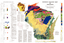
Bedrock Geologic Map of Wisconsin
Describes the types of rocks found throughout the state by age and explains how to interpret the accompanying cross section.-
Bedrock Geologic Map of Wisconsin [GIS data]
1982
GIS Data: MrSID files (.sid file format), coverage (.e00 file format)
-
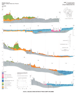
Pleistocene Geology of Wood County, Wisconsin
-
Pleistocene Geology of Wood County, Wisconsin [GIS data]
1991
GIS Data: Shapefiles (.shp file format), MrSID files (.sid file format)
-
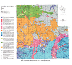
Map Showing the Pleistocene Geology of Wood County, Wisconsin [plate 1]
1991
Map: 25.5 in x 23 in, scale 1:100,000

Publications Catalog
Wisconsin Geological and Natural History Survey