-
Distribution of Radionuclides in Wisconsin Groundwater
Open-file report; contains unpublished data that has not yet been peer-reviewed. -
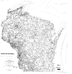
Average ground-water temperature map, Wisconsin.
Open-file report; contains unpublished data that has not yet been peer-reviewed. -
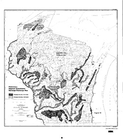
Ground-Water Studies in Wisconsin, A Progress Report
Open-file report; contains unpublished data that has not yet been peer-reviewed. -
Impacts of Land Use and Groundwater Flow on the Temperature of Wisconsin Trout Streams: Final Report
Open-file report; contains unpublished data that has not yet been peer-reviewed. -
Ground Water Resources of Wisconsin
Open-file report; contains unpublished data that has not yet been peer-reviewed. -
Methods and Best Practices for Surveying Springs in Wisconsin
Description of the field methods and data management procedures used to produce the Springs Inventory (see Bulletin 113). -
Mineral Transformation and Release of Arsenic to Solution under the Oxidizing Conditions of Well Disinfection
Open-file report; contains unpublished data that has not yet been peer-reviewed. -
Inventory of Wisconsin's Springs
Open-file report; contains unpublished data that has not yet been peer-reviewed. -
Assessing the Ecological Status and Vulnerability of Springs in Wisconsin
Open-file report; contains unpublished data that has not yet been peer-reviewed.-
Assessing the Ecological Status and Vulnerability of Springs in Wisconsin [GIS Data]
2008
GIS Data: Shapefiles, JPEG images, Microsoft Access database
-
Depth-to-Bedrock Mapping in Wisconsin
Depth-to-bedrock maps show the thickness of unconsolidated materials overlying bedrock. These maps provide a key link between the underlying geology, groundwater flow, and land use and are important in guiding activities such as permitting, bridge construction, and the land application of waste products in sensitive areas. Given their role in guiding...

Publications Catalog
Wisconsin Geological and Natural History Survey