Skip to content
University of Wisconsin–Madison
University of Wisconsin-Madison Crest

Publications Catalog

Wisconsin Geological and Natural History Survey
  • WGNHS Home
  • Catalog
  • Browse Publications
  1. Home
  2. Publications

Location Clear

Counties

  • Walworth - 2

Tags

  • Bedrock Geology - 2
  • Groundwater - 2
  • Surficial Geology - 2
  • Surface Water - 1
  • Topography - 1

Resource Types

  • Map - 2
  • Report - 2

Authors

  • Borman, R.G. - 1
  • Gotkowitz, M.B. - 1
  • Schoephoester, P.R. - 1

Series

  • Information Circular - 1
  • Open-File Report - 1
close

2 publications found for "water table"

Counties: Walworth

Filter Results
  • Ground-Water Resources and Geology of Walworth County, Wisconsin

    • PDF IC34

      Ground-Water Resources and Geology of Walworth County, Wisconsin

      Borman, R.G.;

      1976

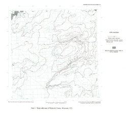
      Report: 45 p. + map (scale 1:125,000)

    • PDF IC34-plate01

      Water-Table Map of Walworth County, Wisconsin, 1973 [plate 1]

      1976

  • Groundwater Data Compilation for the Geneva Lake, Wisconsin, Area

    Open-file report; contains unpublished data that has not yet been peer-reviewed.
    • PDF WOFR2006-02

      Groundwater Data Compilation for the Geneva Lake, Wisconsin, Area

      Gotkowitz, M.B.; Schoephoester, P.R.;

      2006

      Report: 24 p. + 5 plates

    • PDF WOFR2006-02-plate01

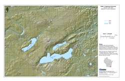
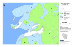
      Regional Overview, Geneva Lake Area, Walworth County, Wisconsin [plate 1]

      2006

      Map: 11 in x 17 in, scale 1:100,000

    • PDF WOFR2006-02-plate02

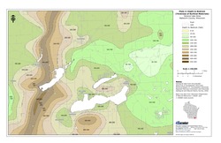
      Bedrock Geology, Geneva Lake Area, Walworth County, Wisconsin [plate 2]

      2006

      Map: 11 in x 17 in, scale 1:100,000

    • PDF WOFR2006-02-plate03

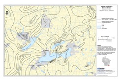
      Elevation of Bedrock Surface, Geneva Lake Area, Walworth County, Wisconsin [plate 3]

      2006

      Map: 11 in x 17 in, scale 1:100,000

    • PDF WOFR2006-02-plate04

      Depth to Bedrock (Thickness of Surficial Materials), Geneva Lake Area, Walworth County, Wisconsin [plate 4]

      2006

      Map: 11 in x 17 in, scale 1:100,000

    • PDF WOFR2006-02-plate05

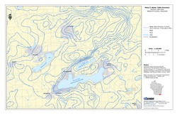
      Water Table Elevation, Geneva Lake Area, Walworth County, Wisconsin [plate 5]

      2006

      Map: 11 in x 17 in, scale 1:100,000

You can also access this registry using the API (see API Docs).
University logo that links to main university website Part of the Universities of Wisconsin

Accessibility

  • Non-Discrimination Statement & How to File a Complaint
  • Disability Accommodation Requests

Quick Links

  • Wisconsin Geological and Natural History Survey
  • Find an Expert
  • Jobs at WGNHS
  • Make a Donation

Contact Us

  • 3817 Mineral Point Rd.
    Madison, WI 53705-5100
  • Email: info@wgnhs.wisc.edu
  • Phone: (608) 262-1705
    • facebook
    • x twitter
    • instagram
    • youtube
    • pinterest
    • linkedin

Website feedback, questions or accessibility issues: website@wgnhs.wisc.edu | Learn more about accessibility at UW–Madison.

Powered by CKAN | Privacy Notice | © 2025 Board of Regents of the University of Wisconsin System.

Site icons More open menu close search search search envelope pinterest-p twitter youtube facebook instagram Collapse Expand next slide previous slide Footer Crest