-
Pleistocene Geology of Vilas County, Wisconsin
-
Pleistocene Geology of Vilas County, Wisconsin (version 3) [GIS data]
1985
GIS Data: GeMS Level 3 file geodatabase (.gdb file format)
-
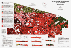
Pleistocene Geology of Vilas County, Wisconsin [plate 1]
1985
Map: 39.5 in x 26.7 in, scale 1:100,000
-
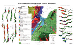
Pleistocene Geology of Brown County, Wisconsin
-
Pleistocene Geology of Brown County, Wisconsin [GIS data]
1985
GIS Data: Shapefiles (.shp file format), MrSID files (.sid file format)
-
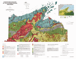
Pleistocene Geology of the Superior Region, Wisconsin
-
Pleistocene Geology of the Superior Region, Wisconsin (version 2) [GIS data]
1985
GIS Data: GeMS Level 3 file geodatabase (.gdb file format)
-
Pleistocene Geology of the Superior Region, Wisconsin [plate 1]
1985
Map: 35.9 in x 27.8 in, scale 1:250,000

Publications Catalog
Wisconsin Geological and Natural History Survey