-
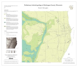
Preliminary Bedrock Geology of Sheboygan County, Wisconsin
Open-file report; contains unpublished data that has not yet been peer-reviewed.-
Preliminary Bedrock Geology of Sheboygan County, Wisconsin (version 2) [GIS data]
2013
GIS Data: GeMS file geodatabase (.gdb file format)
-
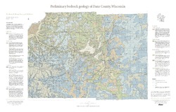
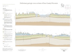
Preliminary Bedrock Geology of Dane County, Wisconsin
This map, produced at a scale of 1:100,000, reveals the intricate layers of bedrock below Dane County. Available as a map (plate 1), cross sections (plate 2), and GIS data. Open-file report; contains unpublished data that has not yet been peer-reviewed.-
Preliminary Bedrock Geology of Dane County, Wisconsin [plate 1]
2013
Map: 39 in x 25 in, scale 1:100,000
-
Preliminary Bedrock Geology of Dane County, Wisconsin [GIS data]
2013
GIS Data: Documents (.pdf file format), shapefiles (.shp file format)
-
-
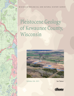
Pleistocene Geology of Kewaunee County, Wisconsin
Kewaunee County, at the southern end of the Door Peninsula, was overrun by glaciers many times. Author Lee Clayton describes the county's complex glacial geology, from the surface soil down to solid rock. The accompanying map shows the placement of glacial sediments as well as glacial and post-glacial stream and lake sediments.-
Pleistocene Geology of Kewaunee County, Wisconsin [GIS data]
2013
GIS Data: Shapefiles (.shp file format)
-
Pleistocene Geology of Kewaunee County, Wisconsin [plate 1]
2013
Map: 21.5 in x 18 in, scale 1:100,000

Publications Catalog
Wisconsin Geological and Natural History Survey