-
Depth to Silurian Bedrock in Eastern Wisconsin
Silurian-aged bedrock in eastern Wisconsin is shallow, fractured, and contains groundwater that is susceptible to surface water contamination. Revisions to Wisconsin state rules ATCP50 and NR151 to regulate manure spreading over this Silurian-aged bedrock create the need for a depth-to-bedrock map of eastern WI. The Wisconsin Geological and Natural...-
Depth to Silurian Bedrock in Eastern Wisconsin [dataset 1]
2025
GIS Data: File geodatabase (.gdb file format)
-
-
Hydrogeological Characterization of the Town of Lincoln, Kewaunee County, Wisconsin
Report, maps, and GIS data cataloging the groundwater and hydrogeologic conditions in Kewaunee County's Town of Lincoln.-
Hydrogeological Characterization of the Town of Lincoln, Kewaunee County, Wisconsin
2017
Report: 33 p., 8 plates, 11 in x 17 in, scale 1:50,000
-
Hydrogeological characterization of the Town of Lincoln, Kewaunee County, Wisconsin [GIS data]
2017
GIS Data: Shapefiles (.shp file format)
-
-
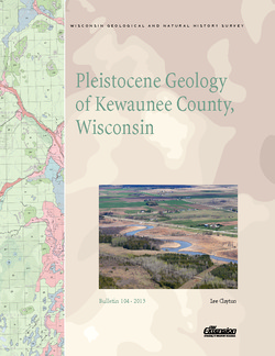
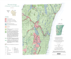
Pleistocene Geology of Kewaunee County, Wisconsin
Kewaunee County, at the southern end of the Door Peninsula, was overrun by glaciers many times. Author Lee Clayton describes the county's complex glacial geology, from the surface soil down to solid rock. The accompanying map shows the placement of glacial sediments as well as glacial and post-glacial stream and lake sediments.-
Pleistocene Geology of Kewaunee County, Wisconsin [GIS data]
2013
GIS Data: Shapefiles (.shp file format)
-
Pleistocene Geology of Kewaunee County, Wisconsin [plate 1]
2013
Map: 21.5 in x 18 in, scale 1:100,000

Publications Catalog
Wisconsin Geological and Natural History Survey