-
A Subsurface Study of the St. Peter Sandstone in Southern and Eastern Wisconsin
-
Structure Contour Map of the Pre-St. Peter Sandstone Erosion Surface in Southern and Eastern Wisconsin [plate 1]
1985
Map: 39.7 in x 23.5 in, scale 1:750,000
-
Paleogeologic Map of the Pre-St. Peter Sandstone Surface in Southern and Eastern Wisconsin & Thickness Map of the St. Peter Sandstone in Southern and Eastern Wisconsin [plate 2]
1985
Map: 39.4 in x 23.6 in, scale 1:750,000
-
Ground-Water Resources of Waukesha County, Wisconsin
-
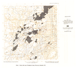
Water Table Map of Waukesha County, Wisconsin, December 1972 [plate 1]
1975
Map: 18 in x 16 in, scale 1:125,000
-
Pleistocene Geology of Southern Wisconsin
Field trip guide with special papers by R.F. Black, N.K. Bleuer, F.D. Hole, N.P. Lasca, and L.J. Maher, Jr., 1970, 175 p.

Publications Catalog
Wisconsin Geological and Natural History Survey