-
Geologic Summary of the Ashland 2° Quadrangle
Open-file report; contains unpublished data that has not yet been peer-reviewed.-
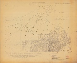
Preliminary Bedrock Geologic Map: Ashland Quadrangle
1979
Map: 4 p., 1 plate, 29.22 in x 25.65 in, scale 1:250,000
-
Shoreline Erosion in Southeastern Wisconsin
Open-file report; contains unpublished data that has not yet been peer-reviewed. -
A Geological Reconnaissance of Bender County Park, Milwaukee County, Wisconsin
Open-file report; contains unpublished data that has not yet been peer-reviewed.

Publications Catalog
Wisconsin Geological and Natural History Survey