-
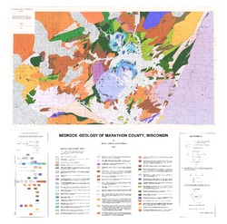
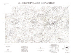
Precambrian Geology of Marathon County, Wisconsin
-
GIS Data for the Precambrian Geology of Marathon County, Wisconsin (version 2) [dataset 1]
1983
GIS Data: GeMS Level 3 file geodatabase (.gdb file format), shapefiles (.shp file format), GeoPackage (.gpkg file format)

Publications Catalog
Wisconsin Geological and Natural History Survey