-
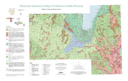
Preliminary Quaternary Geology of Fond du Lac County, Wisconsin
Open-file report-
Preliminary Quaternary Geology of Fond du Lac County, Wisconsin [plate 1]
2014
Map: 32 in x 20.25 in, scale 1:100,000
-
Preliminary Quaternary Geology of Fond du Lac County, Wisconsin [GIS data]
2014
GIS Data: Shapefiles (.shp file format)
-
-
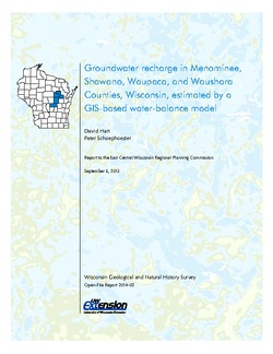
Groundwater Recharge in Menominee, Shawano, Waupaca, and Waushara Counties, Wisconsin, Estimated by a GIS-Based Water-Balance Model
This open-file report documents the recharge model created for the East Central Wisconsin Regional Planning Commission. Includes the resulting recharge map, a useful tool for land-use planners interested in identifying important groundwater recharge areas.

Publications Catalog
Wisconsin Geological and Natural History Survey