-
Bedrock Geology of Jefferson County, Wisconsin
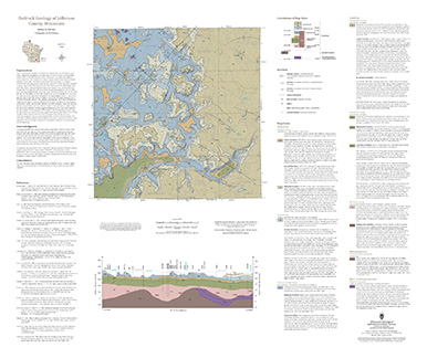
Located in southeast Wisconsin, Jefferson County is almost entirely blanketed by sediments that were delivered or shaped by the ice sheet that covered this area during the last ice age. New mapping interprets the distribution of the bedrock surface that is buried beneath those glacial sediments as interpreted by three drill cores, over 13,000 well...-
GIS Data for the Bedrock Geology of Jefferson County, Wisconsin [dataset 1]
2024
GIS Data: GeMS file geodatabase, geopackage, shapefiles, metadata
-
Bedrock Elevation Raster for the Bedrock Geology of Jefferson County, Wisconsin [dataset 2]
2024
GIS Data: File geodatabase, metadata
-
Geochemical Data for the Bedrock Geology of Jefferson County, Wisconsin [dataset 3]
2024
Data: Excel spreadsheet
-
Geologic Map of the Durwards Glen 7.5-Minute Quadrangle, Columbia and Sauk Counties, Wisconsin
The Durwards Glen 7.5-minute quadrangle map is located in Columbia and Sauk counties, southeast of the city of Baraboo. This geologic map includes Precambrian through Quaternary units. New mapping has focused on subdividing the Baraboo Quartzite into four separate members and delineating Quaternary deposits in greater detail than prior work.-
Geologic Map of the Durwards Glen 7.5-Minute Quadrangle, Columbia and Sauk Counties, Wisconsin
2024
Map: 35 x 40 in, scale 1:24,000
-
GIS Data for the Geologic Map of the Durwards Glen 7.5-Minute Quadrangle, Columbia and Sauk Counties, Wisconsin [dataset 1]
2024
GIS Data: GeMS file geodatabase, shapefiles, geopackage, metadata
-

Publications Catalog
Wisconsin Geological and Natural History Survey