-
Wisconsin Groundwater-Level Monitoring Network Improvements, 2022-2024
This report documents work completed as part of a grant from the U.S. Geological Survey's National Groundwater Monitoring Network (NGWMN) program. It provides an overview of the Wisconsin Groundwater-Level Monitoring Network (WGLMN) and provides detailed description of well evaluation and repair activities, and drilling of new monitoring wells across the... -
Depth to Bedrock in Lafayette County, Wisconsin
The depth-to-bedrock raster of Lafayette County is a continuous model of surficial sediment thickness with a cell size resolution of 32.8 ft (10 m). Results show that the depth to bedrock in Lafayette County varies depending on physiographic setting. The largest values occur in the Pecatonica River valley, where more than 100 ft (30.5 m) of unconsolidated...-
Depth to Bedrock in Lafayette County, Wisconsin [dataset 1]
2025
GIS Data: File geodatabase (.gdb file format)
-
-
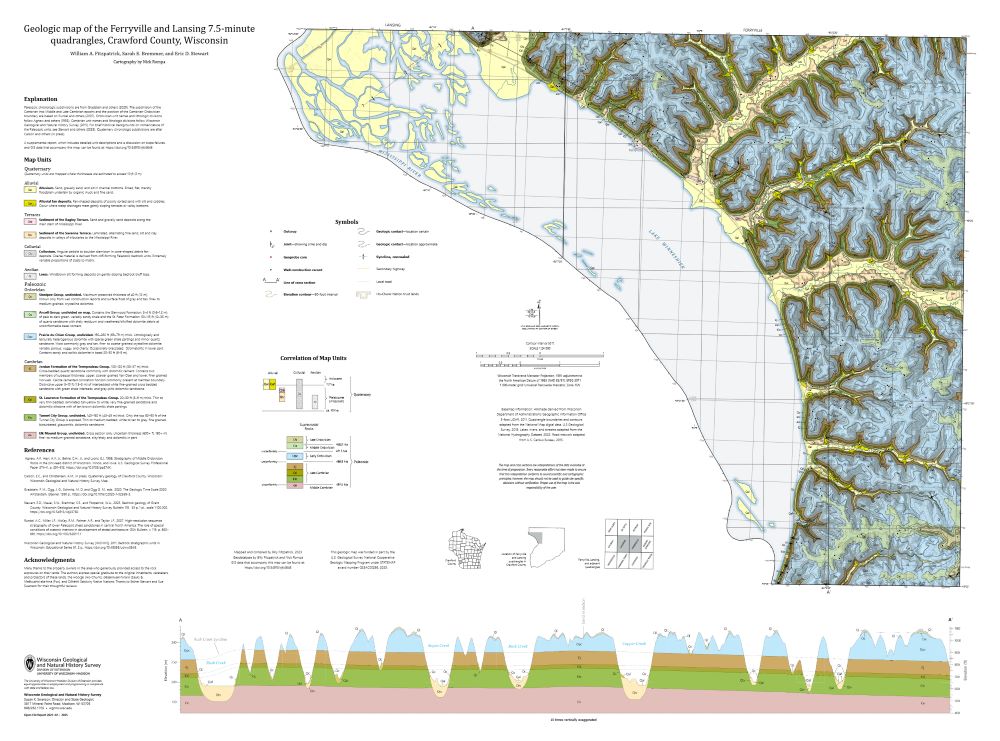
Geologic Map of the Ferryville and Lansing 7.5-Minute Quadrangles, Crawford County, Wisconsin
The geologic map of the Ferryville and Lansing 7.5-minute quadrangles (Crawford County), located in the Driftless Area of southwestern Wisconsin, provides new observations and lithologic descriptions of the area's geology. This work supports the Wisconsin Department of Transportation's ongoing efforts to mitigate slope failures along the Wisconsin State...-
Geologic Map of the Ferryville and Lansing 7.5-Minute Quadrangles, Crawford County, Wisconsin
2025
Map: 41.5 in x 30.75 in, scale 1:24,000
-
GIS Data for the Geologic Map of the Ferryville and Lansing 7.5-Minute Quadrangles, Crawford County, Wisconsin [dataset 1]
2025
GIS Data: GeMS Level 3 file geodatabase (.gdb file format) and GeoPackage (.gpkg file format)
-
-
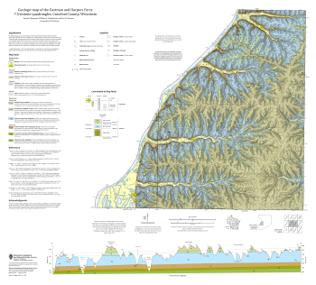
Geologic Map of the Eastman and Harpers Ferry 7.5-Minute Quadrangles, Crawford County, Wisconsin
The geologic map of the Eastman and Harpers Ferry 7.5-minute quadrangles (Crawford County), located in the Driftless Area of southwestern Wisconsin, provides new observations and lithologic descriptions of the area's geology. This work supports the Wisconsin Department of Transportation's ongoing efforts to mitigate slope failures along the Wisconsin...-
Geologic Map of the Eastman and Harpers Ferry 7.5-Minute Quadrangles, Crawford County, Wisconsin
2025
Map: 36 in x 32.5 in, scale 1:24,000
-
GIS Data for the Geologic Map of the Eastman and Harpers Ferry 7.5-Minute Quadrangles, Crawford County, Wisconsin [dataset 1]
2025
GIS Data: GeMS Level 3 file geodatabase (.gdb file format) and GeoPackage (.gpkg file format)
-
-
Bedrock Geology of Grant County, Wisconsin
Three-dimensional bedrock mapping of Grant County at a scale of 1:100,000 provides new baseline information on the distribution of geologic units. Grant County contains Paleozoic bedrock units ranging in age from Silurian to Cambrian. Gentle folds and small faults deform the Paleozoic sequence and were mapped based on structure contours of the base of the...-
GIS Data for Bedrock Geology of Grant County, Wisconsin [dataset 1]
2025
GIS Data: GeMS Level 3 file geodatabase (.gdb), GeoPackage, metadata
-
Geochemical Data for Bedrock Geology of Grant County, Wisconsin [dataset 2]
2025
Data: Spreadsheet (.csv)
-
GIS Data for Bedrock Geology of Grant County, Wisconsin [dataset 3]
2025
GIS Data: File geodatabase (.gdb) raster datasets, metadata

Publications Catalog
Wisconsin Geological and Natural History Survey