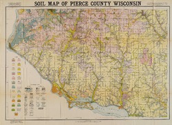
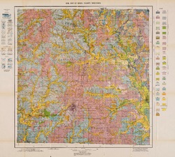
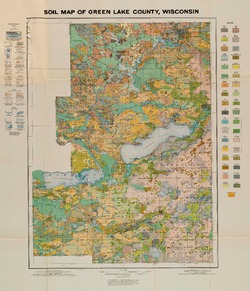
Order by Best Match A - Z Z - A Oldest Newest Go 4 publications found Series: Bulletin Authors: Edwards, M.J. Filter Results Soil Survey of Pierce County, Wisconsin B060A Soil Survey of Pierce County Whitson, A.R.; Musbach, F.L.; Geib, W.J.; Lathrop, H.R.; Pierre, W.H.; Edwards, M.J.; Templin, E.H.; Bailey, E.H.; 1930 Report: 71 p. + map (scale 1:63,360) B060A-map01 Soil Map of Pierce County Wisconsin Whitson, A.R.; Geib, W.J.; Lathrop, H.R.; Edwards, M.J.; Templin, E.H.; Bailey, E.H.; 1930 Map: Scale 1 in = 1 mile Soil Survey of Green County, Wisconsin B053C Soil Survey of Green County Whitson, A.R.; Dunnewald, T.J.; Edwards, M.J.; Vosquil, W.; Whitson, K.; Anderson, A.C.; O'Connell, F.J.; 1930 Report: 82 p. + map (scale 1:62,500) B053C-map01 Soil Map of Green County, Wisconsin Geib, W.J.; Dunnewald, T.J.; Edwards, M.J.; Vosquil, W.; Whitson, K.; Anderson, A.C.; O'Connell, F.J.; 1930 Map: Scale 1: 62,500 Soil Survey of Green Lake County, Wisconsin B061C Soil Survey of Green Lake County Whitson, A.R.; Geib, W.J.; Chapman, H.; Magistad, O.; O'Connell, F.J.; Dunnewald, T.J.; Whitson, K.; Anderson, A.C.; Bailey, E.H.; Edwards, M.J.; 1929 Report: 79 p. + map (scale 1:62,500) B061C-map01 Soil Map of Green Lake County, Wisconsin Geib, W.J.; Chapman, H.; Magistad, O.; O'Connell, F.J.; Dunnewald, T.J.; Whitson, K.; Anderson, A.C.; Bailey, E.H.; Edwards, M.J.; 1929 Map: Scale 1:62,500 Soil Survey of Monroe County, Wisconsin B060B Soil Survey of Monroe County Whitson, A.R.; Geib, W.J.; Chapman, H.; Bartholomew, R.; Stockstad, O.L.; Anderson, A.C.; Edwards, M.J.; Bailey, E.H.; 1931 Report: 93 p. + map (scale 1:62,500)