Order by Best Match A - Z Z - A Oldest Newest Go 4 publications found Series: Bulletin Counties: Menominee Filter Results Soil Resources and Forest Ecology of Menominee County, Wisconsin B085 Soil Resources and Forest Ecology of Menominee County, Wisconsin Milfred, C.J.; Olson, G.W.; Hole, F.D.; Baxter, F.P.; Goff, F.G.; Creed, A.; Stearns, F.; 1967 Report: 203 p. B085-map01 Soil Map of Menominee County, Wisconsin Milfred, C.J.; Olson, G.W.; Baxter, F.P.; Goff, F.G.; Nielsen, G.A.; Claeys, P.; Bouma, J.; Ciolkosz, E.J.; Hole, F.D.; 1967 Map: 19 in x 18.4 in, scale 1:63,360 B085-map02 Glacial Geology: Menominee County, Wisconsin 1967 Map: 18.8 in x 17.25 in, scale 1:63,360 B085-map03 Vegetative Cover: Menominee County, Wisconsin Hole, F.D.; Goff, F.G.; Baxter, F.P.; 1967 Map: 18.8 in x 17.4 in, scale 1:63,360 Reconnoissance [sic] Soil Survey of North Eastern Wisconsin B047 Reconnoissance [sic] Soil Survey of North Eastern Wisconsin Whitson, A.R.; Geib, W.J.; Thompson, C.; Post, C.B.; Buser, A.L.; Schoenmann, L.R.; Taylor, A.E.; 1916 Report: 87 p. B047-map01 
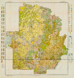
Soil Map: Wisconsin, Reconnoissance [sic] Survey - Northeastern Wisconsin Sheet Geib, W.J.; Buser, A.L.; Thompson, C.C.; Post, C.B.; Schoenmann, L.R.; Taylor, A.E.; 1916 Map: 23.6 in x 24.9 in, scale 1 in = 3 miles The Soils of Northern Wisconsin B055-1921 Soil Survey of Northern Wisconsin Whitson, A.R.; Dunnewald, T.J.; Thompson, C.; 1921 Report: 45 p. B055-1921-map01 General Map of the Soils of Northern Wisconsin Whitson, A.R.; Thompson, C.; Dunnewald, T.J.; 1921 Map: 34.3 in x 21.2 in, scale 1:380,160 The Fossils and Stratigraphy of the Middle Devonic of Wisconsin B021 The Fossils and Stratigraphy of the Middle Devonic of Wisconsin Cleland, H.F.; 1911 Report: 222 p. B021-map01 Geologic Map of Eastern Wisconsin Cleland, H.F.; 1911 Map: 8.3 in x 11.7 in