-
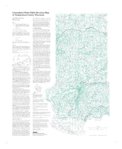
Generalized Water-Table Elevation Map of Trempealeau County, Wisconsin
-
Generalized Water-Table Elevation Map of Trempealeau County, Wisconsin
1998
Map: 27 in x 33 in, scale 1:100,000
-
Generalized Water-Table Elevation Map of Trempealeau County, Wisconsin" [GIS data]
1998
Map: Coverage (.e00 file format)
-

Publications Catalog
Wisconsin Geological and Natural History Survey