-
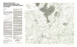
Generalized Water-Table Elevation of Chippewa County, Wisconsin
-
Generalized Water-Table Elevation of Chippewa County, Wisconsin
1988
Map: 36 in x 22 in, scale 1:100,000
-
GIS Data for the Generalized Water-Table Elevation of Chippewa County, Wisconsin [dataset 1]
1988
GIS Data: File geodatabase (.gdb file format)
-
-
Potential Yields of Wells in the Bedrock Aquifers of Chippewa County, Wisconsin
-
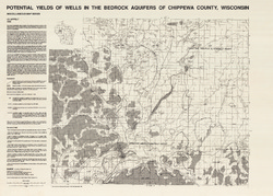
Potential Yields of Wells in the Bedrock Aquifers of Chippewa County, Wisconsin
1988
Map: 31.5 in x 22.5 in, scale 1:100,000
-
-
Potential Yields of Wells in the Sand and Gravel Aquifer of Chippewa County, Wisconsin
-
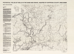
Potential Yields of Wells in the Sand-and-Gravel Aquifer of Chippewa County, Wisconsin
1988
Map: 31 in x 22.5 in, scale 1:100,000
-

Publications Catalog
Wisconsin Geological and Natural History Survey