-
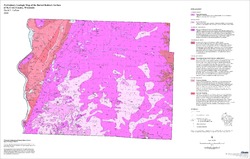
Compilation of Outcrops of Precambrian Rock in Northern Oconto County and Adjacent Segments of Forest, Langlade, Marinette, and Menominee Counties, Northeast...
Open-file report; contains unpublished data that has not yet been peer-reviewed. -
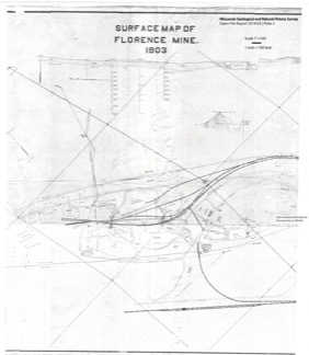
Florence Iron Mine: Historical Maps Showing Location of Surface Development, Regional Setting, and Underground Workings
From 1880 to 1931, an extensive iron mine operated near the city of Florence in northeast Wisconsin. These 21 maps from its middle years of operation are the only surviving records of what exists below the surface. These maps are of historical interest for their record of surface features that are no longer in existence. They may also have potential...-
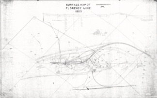
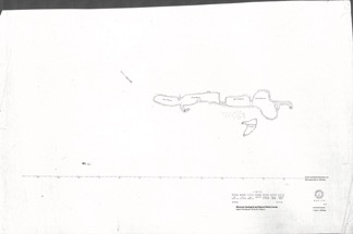
Extent of Florence Mine Surface Development in 1903 [plate 1]
2021
Map: 56 in x 35.1 in, scale 1 in = 100 ft
-
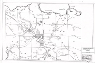
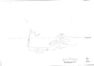
Florence Mine Surface Development in 1903 With Annotated Shaft Locations [plate 2]
2021
Map: 33.3 in x 38.2 in, scale 1 in = 100 ft
-
Mines in the Area Adjacent to the City of Florence in 1928 [plate 3]
2021
Map: 29.7 in x 19.7 in, scale 1 in = 1/4 mile
-
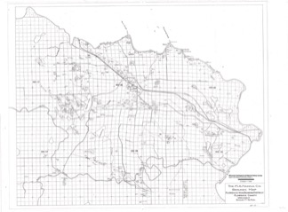
Florence Iron Mining District Covering Part of Florence County [plate 4]
2021
Map: 36.3 in x 26.8 in, scale 1 in = 1/2 mile
-
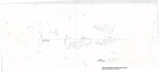
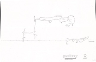
Florence Mine Level 1 With Annotated Shaft Locations and Surface Features [plate 5]
2021
Map: 52.8 in x 24.3 in, scale 1 in = 100 ft
-
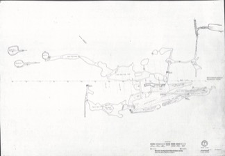
Florence Mine Level 1 (1910), Northwest Ore Zone [plate 7]
2021
Map: 27 in x 19 in, scale 1 in = 60 ft
-
Florence Mine Level 2 (1907), Northwest Ore Zone [plate 9]
2021
Map: 27.1 in x 18.8 in, scale 1 in = 60 ft
- 12 more...
-
Hydrologic Assessment of the Kickapoo Watershed, Southwestern Wisconsin
Open-file report; contains unpublished data that has not yet been peer-reviewed.-
Hydrologic Assessment of the Kickapoo Watershed, Southwestern Wisconsin
1998
Report: 81 p. + 4 plates
-
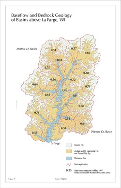
Baseflow and Bedrock Geology of Basins Above La Farge, WI [figure 7]
1998
Map: 11 in x 17 in, scale 1:150,000
-
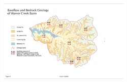
Baseflow and Bedrock Geology of Warner Creek Basin [figure 8]
1998
Map: 17 in x 11 in, scale 1:50,000
-
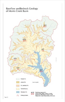
Baseflow and Bedrock Geology of Morris Creek Basin [figure 9]
1998
Map: 11 in x 17 in, scale 1:50,000
-
-
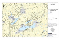
Groundwater Data Compilation for the Geneva Lake, Wisconsin, Area
Open-file report; contains unpublished data that has not yet been peer-reviewed.-
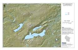
Regional Overview, Geneva Lake Area, Walworth County, Wisconsin [plate 1]
2006
Map: 11 in x 17 in, scale 1:100,000
-
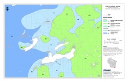
Bedrock Geology, Geneva Lake Area, Walworth County, Wisconsin [plate 2]
2006
Map: 11 in x 17 in, scale 1:100,000
-
Elevation of Bedrock Surface, Geneva Lake Area, Walworth County, Wisconsin [plate 3]
2006
Map: 11 in x 17 in, scale 1:100,000
-
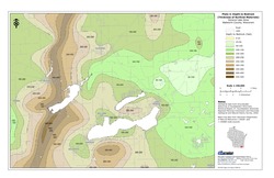
Depth to Bedrock (Thickness of Surficial Materials), Geneva Lake Area, Walworth County, Wisconsin [plate 4]
2006
Map: 11 in x 17 in, scale 1:100,000
-
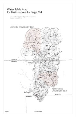
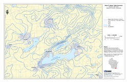
Water Table Elevation, Geneva Lake Area, Walworth County, Wisconsin [plate 5]
2006
Map: 11 in x 17 in, scale 1:100,000
-
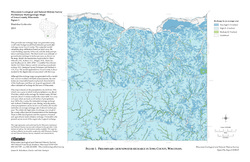
Preliminary Hydrogeologic Maps of Iowa County, Wisconsin
Open-file report; contains unpublished data that has not yet been peer-reviewed.-
Preliminary Hydrogeologic Maps of Iowa County, Wisconsin: Preliminary Groundwater Recharge in Iowa County, Wisconsin [figure 1]
2010
Map: 28 in x 22 in, scale 1:225,000
-
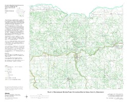
Preliminary Hydrogeologic Maps of Iowa County, Wisconsin: Preliminary Water-Table Elevation Map of Iowa County, Wisconsin [plate 1]
2010
Map: 26 in x 21 in, scale 1:100,000
-
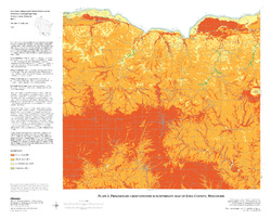
Preliminary Hydrogeologic Maps of Iowa County, Wisconsin: Preliminary Groundwater Susceptibility Map of Iowa County, Wisconsin [plate 2]
2010
Map: 26 in x 21 in, scale 1:100,000
-
-
Preliminary Bedrock Geology of Washington County, Wisconsin
Open-file report; contains unpublished data that has not yet been peer-reviewed.-
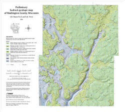
Preliminary Bedrock Geologic Map of Washington County, Wisconsin
2004
Map: 19 in x 17 in, scale 1:100,000
-
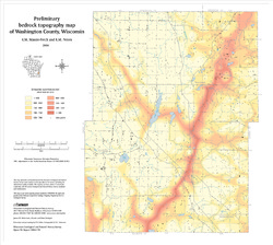
Preliminary Bedrock Topography Map of Washington County, Wisconsin
2004
Map: 19 in x 17 in,scale 1:100,000
-
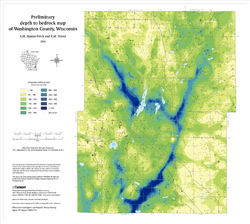
Preliminary Depth to Bedrock Map of Washington County, Wisconsin
2004
Map: 19 in x 17 in, scale 1:100,000
-
-
Preliminary Bedrock Geology of Ozaukee County, Wisconsin
Open-file report; contains unpublished data that has not yet been peer-reviewed.-
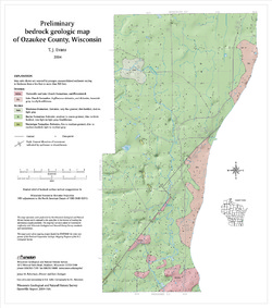
Preliminary Bedrock Geologic Map of Ozaukee County, Wisconsin
2004
Map: 15 in x 17 in, scale 1:100,000
-
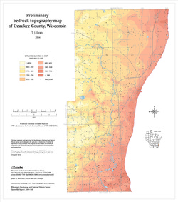
Preliminary Bedrock Topography Map of Ozaukee County, Wisconsin
2004
Map: 15 in x 17 in, scale 1:100,000
-
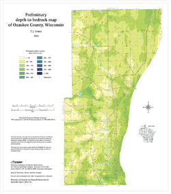
Preliminary Depth to Bedrock Map of Ozaukee County, Wisconsin
2004
Map: 15 in x 17 in, scale 1:100,000
-
-
Preliminary Bedrock Geology of Waukesha County, Wisconsin
Open-file report; contains unpublished data that has not yet been peer-reviewed.-
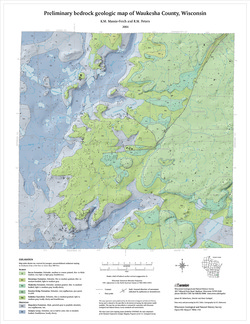
Preliminary Bedrock Geologic Map of Waukesha County, Wisconsin
2004
Map: 17.75 in x 23 in, scale 1:100,000
-
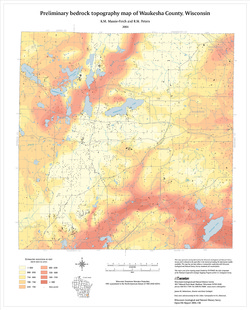
Preliminary Bedrock Topography Map of Waukesha County, Wisconsin
2004
Map: 17.75 in x 23 in, scale 1:100,000
-
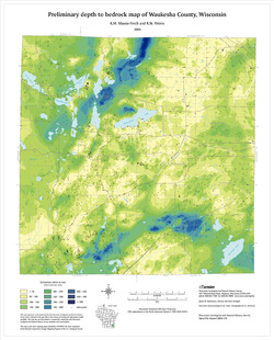
Preliminary Depth to Bedrock Map of Waukesha County, Wisconsin
2004
Map: 17.75 in x 23 in, scale 1:100,000
-
-
Preliminary Bedrock Geology of Milwaukee County, Wisconsin
Open-file report; contains unpublished data that has not yet been peer-reviewed.-
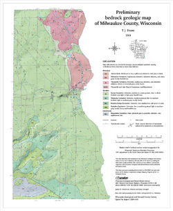
Preliminary Bedrock Geologic Map of Milwaukee County, Wisconsin
2004
Map: 14 in x 17 in, scale 1:100,000
-
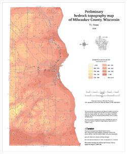
Preliminary Bedrock Topography Map of Milwaukee County, Wisconsin
2004
Map: 14 in x 17 in, scale 1:100,000
-
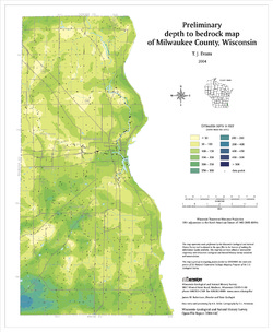
Preliminary Depth to Bedrock Map of Milwaukee County, Wisconsin
2004
Map: 14 in x 17 in, scale 1:100,000
-
-
Preliminary Bedrock Geology of Kenosha County, Wisconsin
Open-file report; contains unpublished data that has not yet been peer-reviewed.-
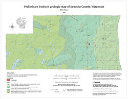
Preliminary Bedrock Geologic Map of Kenosha County, Wisconsin
2004
Map: 18 in x 14 in, scale 1:100,000
-
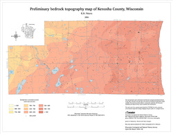
Preliminary Bedrock Topography Map of Kenosha County, Wisconsin
2004
Map: 18 in x 14 in, scale 1:100,000
-
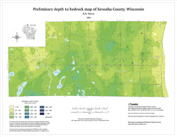
Preliminary Depth to Bedrock Map of Kenosha County, Wisconsin
2004
Map: 18 in x 14 in, scale 1:100,000
-
-
Preliminary Bedrock Geology of Racine County, Wisconsin
Open-file report; contains unpublished data that has not yet been peer-reviewed.-
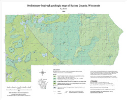
Preliminary Bedrock Geologic Map of Racine County, Wisconsin
2004
Map: 19 in x 15 in, scale 1:100,000
-
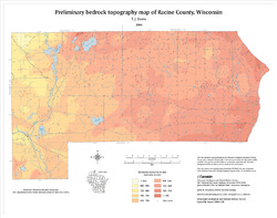
Preliminary Bedrock Topography Map of Racine County, Wisconsin
2004
Map: 19 in x 15 in, scale 1:100,000
-
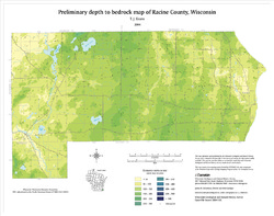
Preliminary Depth to Bedrock Map of Racine County, Wisconsin
2004
Map: 19 in x 15 in, scale 1:100,000
-
-
Preliminary Bedrock Geology of Walworth County, Wisconsin
Open-file report; contains unpublished data that has not yet been peer-reviewed.-
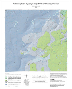
Preliminary Bedrock Geologic Map of Walworth County, Wisconsin
2004
Map: 17.75 in x 22 in, scale 1:100,000
-
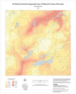
Preliminary Bedrock Topography Map of Walworth County, Wisconsin
2004
Map: 17.75 in x 22 in, scale 1:100,000
-
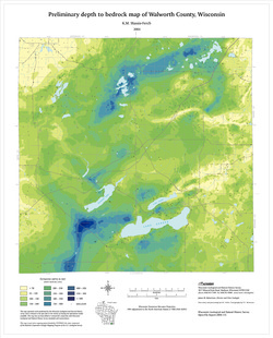
Preliminary Depth to Bedrock Map of Walworth County, Wisconsin
2004
Map: 17.75 in x 22 in, scale 1:100,000
-
-
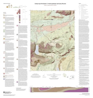
Geologic Map of the Baraboo 7.5-Minute Quadrangle, Sauk County, Wisconsin
The Baraboo quadrangle, records where glaciers stopped in the east-central Baraboo Hills. On this map, 1:24,000 scale, Precambrian igneous and metasedimentary rocks are overlain by Paleozoic sedimentary rocks and, more recently, by glacial deposits. Superb exposures of all three can be found in Devils Lake State Park and Parfreys Glen State Natural Area.-
Geologic Map of the Baraboo 7.5-Minute Quadrangle, Sauk County, Wisconsin
2021
Map: 35 in x 37 in, scale 1:24,000
-
-
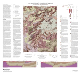
Geologic Map of the Rock Springs 7.5-Minute Quadrangle, Sauk County, Wisconsin
The Rock Springs quadrangle is located in the western Baraboo Hills of south-central Wisconsin. This map, 1:24,000 scale, conveys the rich Precambrian through Quaternary history present on the ground. Here, ancient rocks metamorphosed and folded and were later displaced by a series of faults. Although never glaciated, an ice sheet 8 kilometers to the east...-
Geologic Map of the Rock Springs 7.5-Minute Quadrangle, Sauk County, Wisconsin
2021
Map: 40 in x 36.5 in, scale 1:24,000
-
-
Depth to Bedrock Map of Iowa County, Wisconsin
Open-file report; contains unpublished data that has not yet been peer-reviewed. -
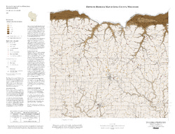
Preliminary Geologic Map of the Buried Bedrock Surface, Brown County, Wisconsin
Open-file report; contains unpublished data that has not yet been peer-reviewed.-
Preliminary Geologic Map of the Buried Bedrock Surface, Brown County, Wisconsin
2011
Map: 26 in x 30 in, scale 1:100,000
-
-
Preliminary Geology of the Buried Bedrock Surface, Pierce County, Wisconsin
Open-file report; contains unpublished data that has not yet been peer-reviewed.-
Preliminary Geology of the Buried Bedrock Surface, Pierce County, Wisconsin
2007
Map: 34 in x 22 in, scale 1:100,000
-
-
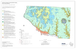
Preliminary Quaternary Geologic Map of the Northern Fox River Lowland, Wisconsin
Open-file report; contains unpublished data that has not yet been peer-reviewed.-
Preliminary Quaternary Geologic Map of the Northern Fox River Lowland, Wisconsin
2007
Map: 42 in x 30.5 in, scale 1:100,000
-
-
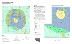
Geology of the Rock Elm Complex, Pierce County, Wisconsin
Open-file report; contains unpublished data that has not yet been peer-reviewed. -
Preliminary Geologic Map of the Buried Bedrock Surface of St. Croix County, Wisconsin
Open-file report; contains unpublished data that has not yet been peer-reviewed.-
Preliminary Geologic Map of the Buried Bedrock Surface of St. Croix County, Wisconsin
2006
Map: 33 in x 21 in, scale 1:100,000
-

Publications Catalog
Wisconsin Geological and Natural History Survey