-
Summary of Survey on Groundwater Vulnerability Mapping Practices in the United States
Open-file report; contains unpublished data that has not yet been peer-reviewed. -
Geologic and Geochemical Controls on Arsenic in Groundwater in Northeastern Wisconsin
Open-file report; contains unpublished data that has not yet been peer-reviewed. -
Tracer Study for Characterization of Groundwater Movement and Contaminant Transport in Fractured Dolomite
Open-file report; contains unpublished data that has not yet been peer-reviewed. -
Evaluation of NURE Hydrogeochemical Data for Use in Wisconsin Groundwater Studies
Open-file report; contains unpublished data that has not yet been peer-reviewed.-
Evaluation of NURE Hydrogeochemical Data for Use in Wisconsin Groundwater Studies
1993
Report: 57 p. + data
-
-
Evaluation of Groundwater Pumping to Reduce the Level of Crystal Lake in Columbia County, Wisconsin
Open-file report; contains unpublished data that has not yet been peer-reviewed.-
Evaluation of Groundwater Pumping to Reduce the Level of Crystal Lake, Columbia County, Wisconsin [appendices]
2012
Data: Multiple PDF files + data files (comma-delimited)
-
Hydrostratigraphy of West-Central Wisconsin: A New Approach to Groundwater Management
Open-file report; contains unpublished data that has not yet been peer-reviewed.-
Hydrostratigraphy of West-Central Wisconsin: A New Approach to Groundwater Management
2008
Report: 10 p. + appendices A1-A7
-
Hydrostratigraphy of West-Central Wisconsin: A New Approach to Groundwater Management [data]
2008
Data: Multiple PDF files + data
-
-
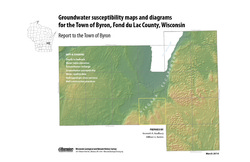
Groundwater Susceptibility Maps, Diagrams, and Report for the Town of Byron, Fond du Lac County, Wisconsin
Open-file report; contains unpublished data that has not yet been peer-reviewed.-
Groundwater Susceptibility Maps and Diagrams for the Town of Byron, Fond du Lac County, Wisconsin
2010
Report: 16 p. + 7 color plates
-
-
Drawdown in the Northeast Groundwater Management Area (Brown, Outagamie, and Calumet Counties, Wisconsin)
Open-file report; contains unpublished data that has not yet been peer-reviewed. -
Groundwater Flow Model for the Geneva Lake Area, Walworth County, Wisconsin
Open-file report; contains unpublished data that has not yet been peer-reviewed. -
Impacts of Land Use and Groundwater Flow on the Temperature of Wisconsin Trout Streams: Final Report
Open-file report; contains unpublished data that has not yet been peer-reviewed. -
Report on the Preliminary Investigation of Arsenic in Groundwater near Lake Geneva, Wisconsin
Open-file report; contains unpublished data that has not yet been peer-reviewed.-
Report on the Preliminary Investigation of Arsenic in Groundwater Near Lake Geneva, Wisconsin
2000
Report: 19 p. + 5 color pages
-
-
Hydrogeology and Groundwater Monitoring of Fractured Dolomite in the Upper Door Priority Watershed, Door County, Wisconsin
Open-file report; contains unpublished data that has not yet been peer-reviewed. -
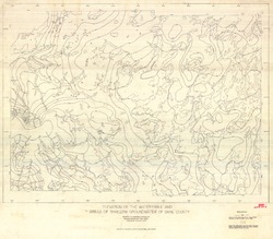
Elevation of the Water Table and Areas of Shallow Groundwater of Dane County
Open-file report; contains unpublished data that has not yet been peer-reviewed.-
Elevation of the Watertable and Areas of Shallow Groundwater of Dane County
1973
Map: 46.3 in x 40.5 in, scale 1:62,500
-
-
Ground-Water Conditions and the Effects of Lake Management on Ground Water in the Snake Lake Area, Woodruff, Wisconsin
Open-file report; contains unpublished data that has not yet been peer-reviewed. -
Assessing private well contamination in Grant, Iowa, and Lafayette counties: The southwest Wisconsin groundwater and geology study
The southwest Wisconsin groundwater and geology study (SWIGG) was a cooperative effort between Grant, Iowa, and Lafayette county governments, with scientists from the U.S. Geological Survey, U.S. Department of Agriculture, Marshfield Clinic Research Institute, and WGNHS. Researchers tested water quality in hundreds of private water wells across the three...-
Assessing private well contamination in Grant, Iowa, and Lafayette counties: The southwest Wisconsin groundwater and geology study
2023
Report: 47 p. (report) + 24 p. (appendices)
-
-
Groundwater Recharge in Menominee, Shawano, Waupaca, and Waushara Counties, Wisconsin, Estimated by a GIS-Based Water-Balance Model
This open-file report documents the recharge model created for the East Central Wisconsin Regional Planning Commission. Includes the resulting recharge map, a useful tool for land-use planners interested in identifying important groundwater recharge areas. -
Groundwater Recharge in Calumet, Outagamie, and Winnebago Counties, Wisconsin, Estimated by a GIS-Based Water-Balance Model
Open-file report; contains unpublished data that has not yet been peer-reviewed. -
Investigating Groundwater Recharge to the Cambrian-Ordovician Aquifer through Fine-Grained Glacial Deposits in the Fox River Valley
Open-file report; contains unpublished data that has not yet been peer-reviewed. -
Delineation of Areas Contributing Groundwater to Springs and Wetlands Supporting the Hine's Emerald Dragonfly, Door County, Wisconsin
Open-file report; contains unpublished data that has not yet been peer-reviewed. -
Groundwater Flow Model for the City of West Bend, Washington County, Wisconsin: Report to the City of West Bend, Wisconsin
Open-file report; contains unpublished data that has not yet been peer-reviewed.

Publications Catalog
Wisconsin Geological and Natural History Survey