-
Geoscience Wisconsin Volume 17
-
Paleoecology and Sedimentology of the Prasopora Zonule in the Dunleith Formation (Ordovician), Upper Mississippi Valley
2007
Journal Article: p. 11-20
-
Trace-Element Signatures and Tectonic Affinities of Proterozoic A-Type Granites and Rhyolites in Central Wisconsin
2007
Journal Article: p. 35-51
-
Coupled Modeling of Gravity and Aeromagnetic Data to Estimate Subsurface Basement Topography in Southeastern Wisconsin
2007
Journal Article: p. 53-64
-
Geoscience Wisconsin Volume 14
Ordovician-Silurian boundary of the Neda Formation-
Ferruginous and Calcareous Oolites at the Ordovician-Silurian Boundary in Illinois
1991
Journal Article: p. 1-21
-
Paleomagnetic Studies of Rock at the Ordovician-Silurian Boundary in Wisconsin
1991
Journal Article: p. 53-63
-
Distribution and Age of Dolomitic and Hematitic Oolites near the Ordovician-Silurian Boundary in Nebraska and Kansas
1991
Journal Article: p. 65-72
-
Geoscience Wisconsin Volume 08
-
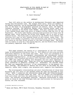
The Pleistocene Stratigraphy and Geomorphology of Central-Southern Wisconsin and Part of Northern Illinois
1983
Journal Article: p. 22-44
-
Geophysical Evidence That the Haeger Till Member Underlies Southern Western Lake Michigan
1983
Journal Article: p. 45-58
-
Geoscience Wisconsin Volume 07
Late Pleistocene History of Southeastern Wisconsin-
Geoscience Wisconsin, Volume 7: Late Pleistocene History of Southeastern Wisconsin
1983
Journal: 111 p.
-
The Wadsworth Till Member of Illinois and the Equivalent Oak Creek Formation of Wisconsin
1983
Journal Article: p. 1-16
-
Quaternary Stratigraphy of the Lower Milwaukee and Menomonee River Valleys, Milwaukee, Wisconsin
1983
Journal Article: p. 24-42
-
The Effect of Lake-Level Fluctuations on the Geomorphic Evolution of the Lake Michigan Bluffs in Wisconsin
1983
Journal Article: p. 43-58
-
Wisconsinan Stratigraphy and Glacial Sequence in Southeastern Wisconsin
1983
Journal Article: p. 59-85
-
Fabric and Depositional Structures in Drumlins near Waukesha, Wisconsin
1983
Journal Article: p. 98-111
-
-
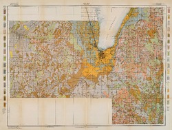
Atlas of the Geological Survey of Wisconsin
Collection of most of the plates accompanying Chamberlin's four-volume Geology of Wisconsin: Survey of 1873-1879.-
Atlas of the Geological Survey of Wisconsin: General Geological Map of Wisconsin [plate 1]
1882
Map: 25.5 in x 30.3 in, scale 1 in = 15 miles
-
Atlas of the Geological Survey of Wisconsin: General Map of Quaternary Formations [plate 2]
1882
Map: 28.2 in x 32.4 in
-
Atlas of the Geological Survey of Wisconsin: General Map of Native Vegetation [plate 2A]
1882
Map: 28.2 in x 32.4 in
-
Atlas of the Geological Survey of Wisconsin: General Map of Soils [plate 2B]
1882
Map: 28.2 in x 32.5 in
-
Atlas of the Geological Survey of Wisconsin: Map of Rainfall and Temperature [plate 2C]
1882
Map: 27.7 in x 32.5 in
-
Atlas of the Geological Survey of Wisconsin: Maps of Subsoils and Native Vegetation of Eastern Wisconsin [plate 3]
1877
Map: 27.82 in x 32.17 in, scale 1 in = 12 miles
-
Atlas of the Geological Survey of Wisconsin: Maps of Topography and Quaternary Formations of Eastern Wisconsin [plate 4]
1877
Map: 27.83 in x 32.06 in, scale 1 in = 12 miles
-
Atlas of the Geological Survey of Wisconsin: Geology and Topography of the Lead Region [plate 5]
1877
Map: 27.68 in x 32.18 in
-
Atlas of the Geological Survey of Wisconsin: Geology and Topography of the Lead Region [plate 6]
1877
Map: 23.98 in x 28.94 in
-
Atlas of the Geological Survey of Wisconsin: Geology and Topography of the Lead Region [plate 8]
1877
Map: 24.03 in x 28.38 in
- 32 more...
-
-
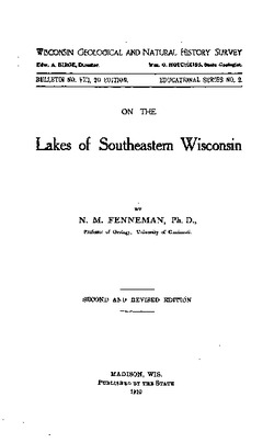
On the Lakes of Southeastern Wisconsin
-
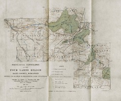
Pre-Glacial Topography of the Four Lakes Region, Dane County, Wisconsin: Showing Its Relation to the Existing Lakes and Streams [plate 37]
1910
Map: 11.6 in x 9.7 in, scale 1 in = 2 miles

Publications Catalog
Wisconsin Geological and Natural History Survey