
Atlas of the Geological Survey of Wisconsin
Data and Resources
-
Atlas of the Geological Survey of Wisconsin: General Geological Map of Wisconsin [plate 1]
1882
Map: 25.5 in x 30.3 in, scale 1 in = 15 miles
-
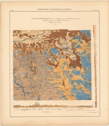
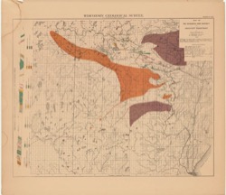
Atlas of the Geological Survey of Wisconsin: General Map of Quaternary Formations [plate 2]
1882
Map: 28.2 in x 32.4 in
-
Atlas of the Geological Survey of Wisconsin: General Map of Native Vegetation [plate 2A]
1882
Map: 28.2 in x 32.4 in
-
Atlas of the Geological Survey of Wisconsin: General Map of Soils [plate 2B]
1882
Map: 28.2 in x 32.5 in
-
Atlas of the Geological Survey of Wisconsin: Map of Rainfall and Temperature [plate 2C]
1882
Map: 27.7 in x 32.5 in
-
Atlas of the Geological Survey of Wisconsin: Maps of Subsoils and Native Vegetation of Eastern Wisconsin [plate 3]
1877
Map: 27.82 in x 32.17 in, scale 1 in = 12 miles
-
Atlas of the Geological Survey of Wisconsin: Maps of Topography and Quaternary Formations of Eastern Wisconsin [plate 4]
1877
Map: 27.83 in x 32.06 in, scale 1 in = 12 miles
-
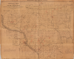
Atlas of the Geological Survey of Wisconsin: Geology and Topography of the Lead Region [plate 5]
1877
Map: 27.68 in x 32.18 in
-
Atlas of the Geological Survey of Wisconsin: Geology and Topography of the Lead Region [plate 6]
1877
Map: 23.98 in x 28.94 in
-
Atlas of the Geological Survey of Wisconsin: Geology and Topography of the Lead Region [plate 8]
1877
Map: 24.03 in x 28.38 in
-
Atlas of the Geological Survey of Wisconsin: Geology and Topography of the Lead Region [plate 9]
1877
Map: 23.97 in x 28.47 in
-
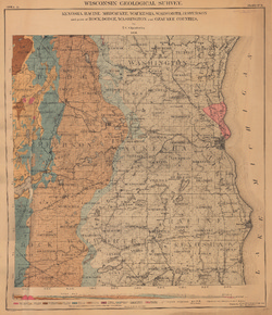
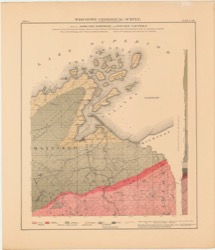
Atlas of the Geological Survey of Wisconsin: Area A. Geological Map of Kenosha, Racine, Milwaukee, Waukesha, Walworth, Jefferson, and Parts of Rock, Dodge, Washington and Ozaukee Counties [plate 10]
1877
Map: 23.91 in x 27.76 in, scale 1 in = 3 miles
-
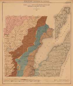
Atlas of the Geological Survey of Wisconsin: Area C. Door and Parts of Kewaunee, Brown, Outagamie, Shawano, Oconto and Marinette Counties [plate 12]
1877
Map: 24.21 in x 28.42 in, scale 1 in = 3 miles
-
Atlas of the Geological Survey of Wisconsin: Area D. Green and Parts of Rock, Dane, Sauk, Iowa and La Fayette Counties [plate 13]
1877
Map: 27.76 in x 32.12 in, scale 1 in = 3 miles
-
Atlas of the Geological Survey of Wisconsin: Area E. Adams, Waushara, Marquette, Columbia, Green Lake and Parts of Sauk, Juneau and Dodge Counties [plate 14]
1877
Map: 24.23 in x 28.55 in, scale 1 in = 3 miles
-
Atlas of the Geological Survey of Wisconsin: Area F. Wood and Parts of Clark, Jackson, Marathon and Portage Counties [plate 15]
1877
Map: 28.32 in x 24.13 in, scale 1 in = 3 miles
-
Atlas of the Geological Survey of Wisconsin: Area G. Grant and Parts of La Fayette, Iowa, Richland and Crawford Counties [plate 16]
1877
Map: 24.23 in x 28.57 in, scale 1 in = 3 miles
-
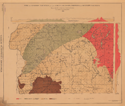
Atlas of the Geological Survey of Wisconsin: Area H. Monroe, Vernon, and Parts of Crawford, Richland, Sauk, Juneau, Jackson, La Crosse and Trempealeau Counties [plate 17]
1880
Map: 23.98 in x 28.23 in, scale 1 in = 3 miles
-
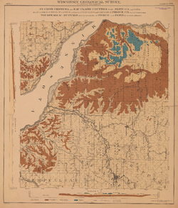
Atlas of the Geological Survey of Wisconsin: Area I. Pierce, Pepin, Dunn, Buffalo, and Parts of Trempealeau, Eau Claire, Chippewa and St. Croix Counties [plate 18]
1880
Map: 24.08 in x 28.22 in, scale 1 in = 3 miles
-
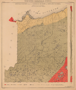
Atlas of the Geological Survey of Wisconsin: Area L. Parts of Ashland, Bayfield and Lincoln Counties [plate 21]
1880
Map: 28.09 in x 32.60 in, scale 1 in = 3 miles
-
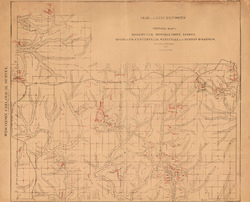
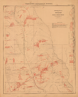
Atlas of the Geological Survey of Wisconsin: Geological Map and Sections of the Region Drained by the Bad and Montreal Rivers [plate 22]
1880
Map: 27.91 in x 32.49 in, scale 1 in = 2 miles
-
Atlas of the Geological Survey of Wisconsin: Map and Sections of Huronian or Iron-Bearing Series at Penokee Gap [plate 23]
1880
Map: 28.24 in x 32.45 in, scale 2000 paces = 1 mile
-
Atlas of the Geological Survey of Wisconsin: Map of the Huronian or Iron-Bearing Series in Ashland and Lincoln Counties. Sheet No. 1 [plate 24]
1880
Map: 32.46 in x 28.15 in, scale 3.6 in = 1 mile
-
Atlas of the Geological Survey of Wisconsin: Map of the Huronian or Iron-Bearing Series in Ashland and Lincoln Counties. Sheet No. 2 [plate 25]
1880
Map: 32.42 in x 28.21 in, scale 3.6 in = 1 mile
-
Atlas of the Geological Survey of Wisconsin: Map of the Huronian or Iron-Bearing Series in Ashland and Lincoln Counties. Sheet No. 3 [plate 26]
1880
Map: 32.46 in x 28.15 in, scale 3.6 in = 1 mile
-
Atlas of the Geological Survey of Wisconsin: Map of Penokee Iron Range West of the Gap [plate 27]
1880
Map: 32.64 in x 28.32 in
-
Atlas of the Geological Survey of Wisconsin: Map of the Menominee Iron Region Including Pine River District Oconto County, and in Part the Sturgeon River District Michigan [plate 28]
1879
Map: 32.55 in x 28.13 in, scale 3/4 in = 1 mile = 2000 steps
-
Atlas of the Geological Survey of Wisconsin: Map of Menominee Iron Region and Adjacent Territory [plate 30]
1880
Map: 32.52 in x 28.13 in
-
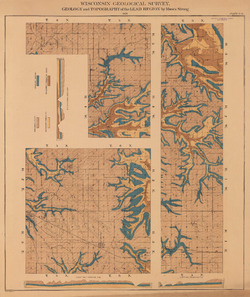
Atlas of the Geological Survey of Wisconsin: General Map of Ore-Bearing Crevices of the Lead Region [plate 31]
1882
Map: 30.93 in x 24.91 in
-
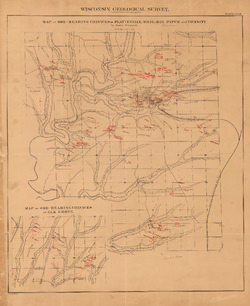
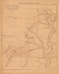
Atlas of the Geological Survey of Wisconsin: Map of Ore-Bearing Crevices of Mineral Point, Dodgeville, Linden, Mifflin, Highland, Centerville and Wingville [plate 32]
1882
Map: 30.72 in x 24.77 in, scale 1.5 in = 1 mile
-
Atlas of the Geological Survey of Wisconsin: Map of Ore-Bearing Crevices of Platteville, Whig, Big Patch and Elk Grove [plate 33]
1882
Map: 24.35 in x 29.84 in, scale 2 2/3 in = 1 mile
-
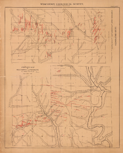
Atlas of the Geological Survey of Wisconsin: Map of Ore-Bearing Crevices of Potosi and Vicinity [plate 34]
1882
Map: 24.61 in x 30.70 in, scale 1 in = 1 mile
-
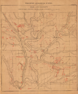
Atlas of the Geological Survey of Wisconsin: Map of Ore-Bearing Crevices of Fairplay, Menomonee and Beetown [plate 35]
1882
Map: 24.61 in x 30.47 in, scale 2 2/3 in = 1 mile
-
Atlas of the Geological Survey of Wisconsin: Map of Ore-Bearing Crevices of Benton and New Diggings [plate 36]
1882
Map: 24.58 in x 29.54 in, scale 4 in = 1 mile
-
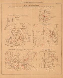
Atlas of the Geological Survey of Wisconsin: Map of Ore-Bearing Crevices of Wiota, Porters Grove, Pigeon and Shullsburg [plate 37]
1882
Map: 24.35 in x 30.02 in, scale 1 in = 660 ft
-
Atlas of the Geological Survey of Wisconsin: Map of Ore-Bearing Crevices and Topography of Shullsburg [plate 38]
1882
Map: 32.54 in x 27.50 in, scale 1 in = 200 ft
-
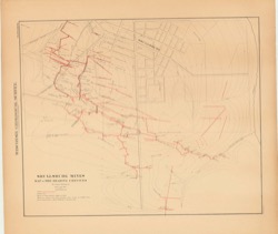
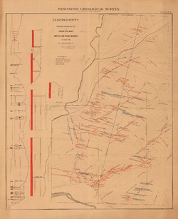
Atlas of the Geological Survey of Wisconsin: Map of Ore-Bearing Crevices and Topography of Hazel Green [plate 39]
1882
Map: 24.65 in x 30.58 in, scale 12 in = 1 mile
-
Atlas of the Geological Survey of Wisconsin: Map of Ore-Bearing Crevices and Topography of Muscalunge [plate 40]
1882
Map: 24.72 in x 30.34 in, scale 1 in = 198 ft
-
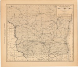
Atlas of the Geological Survey of Wisconsin: Triangulation Map of the U.S. Geodetic Survey [plate 42]
1882
Map: 32.48 in x 27.97 in


Related Collections
-

Map
View Map