-
The Driftless Area: The extent of unglaciated and similar terrains in Wisconsin, Illinois, Iowa, and Minnesota
The Driftless Area of southwestern Wisconsin and northwestern Illinois got its name from the lack of glacial sediment ("drift") covering the landscape. The surficial geology and topography of the Driftless Area are thus distinct from the surrounding region where multiple phases of glaciation left their mark. This pamphlet, a collaborative effort between...-
GIS data for the outline of the Driftless Area and similar terrains in Wisconsin, Illinois, Iowa, and Minnesota
2023
GIS Data: Shapefiles (.shp file format)
-
Page-sized and web-version maps of the Driftless Area and similar terrains in Wisconsin, Illinois, Iowa, and Minnesota
2023
Map: Documents (.pdf file format), images (.tif file format)
-
Central Sands nitrate and neonicotinoids database
The Central Sands nitrate and neonicotinoid database consists of over 100,000 measurements of nitrate and neonicotinoid concentrations in groundwater from wells across Adams, Juneau, Marquette, Portage, Waushara, and Wood counties collected between 1953 and 2021. These counties comprise the Central Sands Groundwater County Collaborative (GSGCC), which...-
Central Sands nitrate and neonicotinoids database
2023
GIS Data: File geodatabase (.gdb file format)
-
-
Central Sands Lakes Study: Annotated Bibliography
The authors of this open-file report scoured the literature for previous studies about the Central Sands area. This bibliography provides an overview of available research related to the hydrogeologic setting and water-budget components of the Central Sands Lakes Study (CSLS). -
International Geological Correlation Project 426: Granite Systems and Proterozoic Lithospheric Processes: 1998 International Field Conference: Proterozoic Granite Systems of the Penokean Terrane in Wisconsin
Open-file report; contains unpublished data that has not yet been peer-reviewed. -
Geology of Central Plain Area of Juneau, Jackson, Adams, Wood, Portage, Waushara, and Marquette Counties
Open-file report; contains unpublished data that has not yet been peer-reviewed. -
Irrigable Lands Inventory--Phase I Groundwater and Related Information
This paper contains hydrogeologic information for the Golden Sands Resource Conservation and Development Area in central Wisconsin. The set of maps includes water-table elevation maps for the following counties: Adams, Jackson, Juneau, Marathon, Marquette, Monroe, Portage, Waupaca, Waushara, and Wood (scale 1:126,720). It also includes a regional aquifer...-
Irrigable Lands Inventory - Phase I Groundwater and Related Information
1981
Report: 13 p., 11 maps, scale 1:126,720 and 1:500,000
- 2 more...
-
-
Bedrock Geology of Wisconsin, West-Central Sheet
Types of bedrock, formation names, major faults, and time period of formation.-
Bedrock Geology of Wisconsin, West-Central Sheet [GIS data]
1988
GIS Data: GeMS file geodatabase (.gdb file format)
-
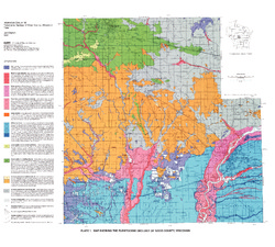
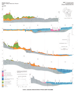
Pleistocene Geology of Wood County, Wisconsin
-
Pleistocene Geology of Wood County, Wisconsin [GIS data]
1991
GIS Data: Shapefiles (.shp file format), MrSID files (.sid file format)
-
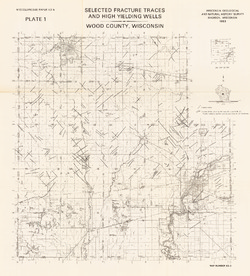
Map Showing the Pleistocene Geology of Wood County, Wisconsin [plate 1]
1991
Map: 25.5 in x 23 in, scale 1:100,000
-
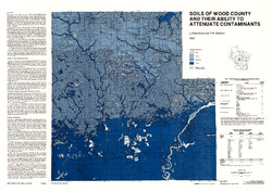
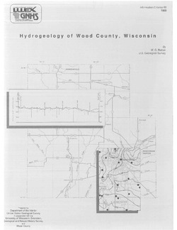
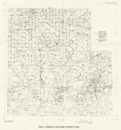
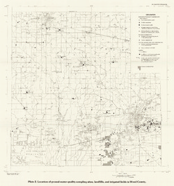
Hydrogeology of Wood County, Wisconsin
-
Location of Ground-Water-Quality Sampling Sites, Landfills, and Irrigated Fields in Wood County [plate 2]
1989
Map: 21.6 in x 23.1 in, scale 1:100,000
-
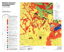
Bedrock Geology of Wood County, Wisconsin
-
Bedrock Geology of Wood County, Wisconsin [GIS data]
1986
GIS Data: Shapefiles (.shp file format), MrSID files (.sid file format)
-
-
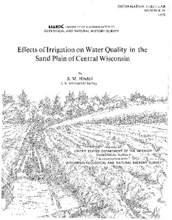
Effects of Irrigation on Water Quality in the Sand Plain of Central Wisconsin
-
Water-Table Maps of the Kellner, Meehan, and Bancroft Subareas, Wisconsin [plate 1]
1978
Map: 32.5 in x 24 in, scale 1:24,000
-
Atlas of the Geological Survey of Wisconsin
Collection of most of the plates accompanying Chamberlin's four-volume Geology of Wisconsin: Survey of 1873-1879.-
Atlas of the Geological Survey of Wisconsin: General Geological Map of Wisconsin [plate 1]
1882
Map: 25.5 in x 30.3 in, scale 1 in = 15 miles
-
Atlas of the Geological Survey of Wisconsin: General Map of Quaternary Formations [plate 2]
1882
Map: 28.2 in x 32.4 in
-
Atlas of the Geological Survey of Wisconsin: General Map of Native Vegetation [plate 2A]
1882
Map: 28.2 in x 32.4 in
-
Atlas of the Geological Survey of Wisconsin: General Map of Soils [plate 2B]
1882
Map: 28.2 in x 32.5 in
-
Atlas of the Geological Survey of Wisconsin: Map of Rainfall and Temperature [plate 2C]
1882
Map: 27.7 in x 32.5 in
-
Atlas of the Geological Survey of Wisconsin: Maps of Subsoils and Native Vegetation of Eastern Wisconsin [plate 3]
1877
Map: 27.82 in x 32.17 in, scale 1 in = 12 miles
-
Atlas of the Geological Survey of Wisconsin: Maps of Topography and Quaternary Formations of Eastern Wisconsin [plate 4]
1877
Map: 27.83 in x 32.06 in, scale 1 in = 12 miles
-
Atlas of the Geological Survey of Wisconsin: Geology and Topography of the Lead Region [plate 5]
1877
Map: 27.68 in x 32.18 in
-
Atlas of the Geological Survey of Wisconsin: Geology and Topography of the Lead Region [plate 6]
1877
Map: 23.98 in x 28.94 in
-
Atlas of the Geological Survey of Wisconsin: Geology and Topography of the Lead Region [plate 8]
1877
Map: 24.03 in x 28.38 in
- 32 more...
-
-
The Wolf River Batholith and Baraboo Interval in Central Wisconsin
Prepared for 32nd Annual Meeting Institute on Lake Superior Geology.

Publications Catalog
Wisconsin Geological and Natural History Survey