-
Depth to Silurian Bedrock in Eastern Wisconsin
Silurian-aged bedrock in eastern Wisconsin is shallow, fractured, and contains groundwater that is susceptible to surface water contamination. Revisions to Wisconsin state rules ATCP50 and NR151 to regulate manure spreading over this Silurian-aged bedrock create the need for a depth-to-bedrock map of eastern WI. The Wisconsin Geological and Natural...-
Depth to Silurian Bedrock in Eastern Wisconsin [dataset 1]
2025
GIS Data: File geodatabase (.gdb file format)
-
-
Wisconsin Groundwater-Level Monitoring Network Improvements, 2018-2021
This report documents work completed as part of a grant from the U.S. Geological Survey’s National Groundwater Monitoring Network (NGWMN) program. It provides an overview of the Wisconsin Groundwater-Level Monitoring Network (WGLMN) and provides detailed description of well evaluation and repair activities, and drilling of new monitoring wells across the... -
Assessing Seasonal Variations in Recharge and Water Quality in the Silurian Aquifer in Areas with Thicker Soil Cover
Documentation of variations in groundwater levels and selected water-quality parameters in four wells completed in the Silurian dolomite aquifer in northeast Wisconsin (Brown, Calumet, Kewaunee, and Manitowoc Counties).-
Assessing Seasonal Variations in Recharge and Water Quality in the Silurian Aquifer in Areas with Thicker Soil Cover
2019
Report: 38 p. + appendix (4 oversized pages)
-
-
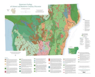
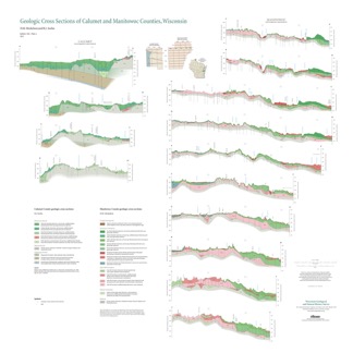
Quaternary Geology of Calumet and Manitowoc Counties, Wisconsin
All of what is now Calumet and Manitowoc Counties was covered by ice during the last great glaciation, between 30,000 and 11,000 years ago. This bulletin explains the glacial history, interprets the deposits left behind, and portrays the distribution of the deposits on a map and cross sections. This report should be useful to planners and development...-
Quaternary Geology of Calumet and Manitowoc Counties, Wisconsin [GIS data]
2017
GIS Data: Shapefiles (.shp file format)
-
Quaternary Geology of Calumet and Manitowoc Counties, Wisconsin [plate 1]
2017
Plate: 35.5 in x 29 in, scale 1:100,000
-
Geologic Cross Sections of Calumet and Manitowoc Counties, Wisconsin [plate 2]
2017
Plate: 36.67 in x 36.67 in, scale 1:100,000
-
Wisconsin Groundwater-Level Monitoring Network Improvement
The Wisconsin Groundwater-Level Monitoring Network consists of 93 wells and 2 spring gaging stations. This report documents work performed on seven of the wells between August 1, 2016 and July 31, 2017, and appendices provide historical reference documents. -
Merging Pleistocene Lithostratigraphy with Geotechnical and Hydrogeologic Data--Examples from Eastern Wisconsin
Open-file report; contains unpublished data that has not yet been peer-reviewed. -
Geology of Wisconsin - Outcrop Descriptions
These descriptions illustrate various geologic formations, features, and characteristics. Individual descriptions are one to ten pages long, and include a map with specific location, a description of geologic features, and a discussion of the geologic significance.-
Adams County: Upper Wisconsin Dells (T14N R6E Sec28)
Report: 3 p.
-
Adams County: Friendship Mound (T17N R6E Sec5)
Report: 2 p.
-
Adams County: Hamilton Mound (T20N R6E Sec36)
Report: 4 p.
-
Ashland County: Mt. Whittelsey (T44N R2W Sec9A)
Report: 3 p.
-
Ashland County: Mellen Gabbro (T45N R2W Sec30)
Report: 3 p.
-
Ashland County: Mellen Granite (T45N R2W Sec31)
Report: 3 p.
-
Ashland County: White River (T46N R4W Sec6)
Report: 2 p.
-
Bayfield County: South Fish Creek (T47N R5W Sec20)
Report: 2 p.
- 123 more...
-
-
A Subsurface Study of the St. Peter Sandstone in Southern and Eastern Wisconsin
-
Structure Contour Map of the Pre-St. Peter Sandstone Erosion Surface in Southern and Eastern Wisconsin [plate 1]
1985
Map: 39.7 in x 23.5 in, scale 1:750,000
-
Paleogeologic Map of the Pre-St. Peter Sandstone Surface in Southern and Eastern Wisconsin & Thickness Map of the St. Peter Sandstone in Southern and Eastern Wisconsin [plate 2]
1985
Map: 39.4 in x 23.6 in, scale 1:750,000
-
Geoscience Wisconsin Volume 14
Ordovician-Silurian boundary of the Neda Formation-
Ferruginous and Calcareous Oolites at the Ordovician-Silurian Boundary in Illinois
1991
Journal Article: p. 1-21
-
Paleomagnetic Studies of Rock at the Ordovician-Silurian Boundary in Wisconsin
1991
Journal Article: p. 53-63
-
Distribution and Age of Dolomitic and Hematitic Oolites near the Ordovician-Silurian Boundary in Nebraska and Kansas
1991
Journal Article: p. 65-72
-
Geoscience Wisconsin Volume 08
-
The Pleistocene Stratigraphy and Geomorphology of Central-Southern Wisconsin and Part of Northern Illinois
1983
Journal Article: p. 22-44
-
Geophysical Evidence That the Haeger Till Member Underlies Southern Western Lake Michigan
1983
Journal Article: p. 45-58
-
Geoscience Wisconsin Volume 07
Late Pleistocene History of Southeastern Wisconsin-
Geoscience Wisconsin, Volume 7: Late Pleistocene History of Southeastern Wisconsin
1983
Journal: 111 p.
-
The Wadsworth Till Member of Illinois and the Equivalent Oak Creek Formation of Wisconsin
1983
Journal Article: p. 1-16
-
Quaternary Stratigraphy of the Lower Milwaukee and Menomonee River Valleys, Milwaukee, Wisconsin
1983
Journal Article: p. 24-42
-
The Effect of Lake-Level Fluctuations on the Geomorphic Evolution of the Lake Michigan Bluffs in Wisconsin
1983
Journal Article: p. 43-58
-
Wisconsinan Stratigraphy and Glacial Sequence in Southeastern Wisconsin
1983
Journal Article: p. 59-85
-
Fabric and Depositional Structures in Drumlins near Waukesha, Wisconsin
1983
Journal Article: p. 98-111
-
-
Atlas of the Geological Survey of Wisconsin
Collection of most of the plates accompanying Chamberlin's four-volume Geology of Wisconsin: Survey of 1873-1879.-
Atlas of the Geological Survey of Wisconsin: General Geological Map of Wisconsin [plate 1]
1882
Map: 25.5 in x 30.3 in, scale 1 in = 15 miles
-
Atlas of the Geological Survey of Wisconsin: General Map of Quaternary Formations [plate 2]
1882
Map: 28.2 in x 32.4 in
-
Atlas of the Geological Survey of Wisconsin: General Map of Native Vegetation [plate 2A]
1882
Map: 28.2 in x 32.4 in
-
Atlas of the Geological Survey of Wisconsin: General Map of Soils [plate 2B]
1882
Map: 28.2 in x 32.5 in
-
Atlas of the Geological Survey of Wisconsin: Map of Rainfall and Temperature [plate 2C]
1882
Map: 27.7 in x 32.5 in
-
Atlas of the Geological Survey of Wisconsin: Maps of Subsoils and Native Vegetation of Eastern Wisconsin [plate 3]
1877
Map: 27.82 in x 32.17 in, scale 1 in = 12 miles
-
Atlas of the Geological Survey of Wisconsin: Maps of Topography and Quaternary Formations of Eastern Wisconsin [plate 4]
1877
Map: 27.83 in x 32.06 in, scale 1 in = 12 miles
-
Atlas of the Geological Survey of Wisconsin: Geology and Topography of the Lead Region [plate 5]
1877
Map: 27.68 in x 32.18 in
-
Atlas of the Geological Survey of Wisconsin: Geology and Topography of the Lead Region [plate 6]
1877
Map: 23.98 in x 28.94 in
-
Atlas of the Geological Survey of Wisconsin: Geology and Topography of the Lead Region [plate 8]
1877
Map: 24.03 in x 28.38 in
- 32 more...
-
-
On the Lakes of Southeastern Wisconsin
-
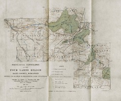
Pre-Glacial Topography of the Four Lakes Region, Dane County, Wisconsin: Showing Its Relation to the Existing Lakes and Streams [plate 37]
1910
Map: 11.6 in x 9.7 in, scale 1 in = 2 miles

Publications Catalog
Wisconsin Geological and Natural History Survey