-
Depth to Silurian Bedrock in Eastern Wisconsin
Silurian-aged bedrock in eastern Wisconsin is shallow, fractured, and contains groundwater that is susceptible to surface water contamination. Revisions to Wisconsin state rules ATCP50 and NR151 to regulate manure spreading over this Silurian-aged bedrock create the need for a depth-to-bedrock map of eastern WI. The Wisconsin Geological and Natural...-
Depth to Silurian Bedrock in Eastern Wisconsin [dataset 1]
2025
GIS Data: File geodatabase (.gdb file format)
-
-
Elevation contours of the Precambrian surface of south-central Wisconsin
Elevation contour data and an accompanying report provide an updated interpretation of the elevation of the top of Precambrian bedrock in south-central Wisconsin. The elevation surface was developed from geologic and geophysical data, and provides new detail on the entrenched bedrock valleys that were incised into the north and south ranges of the Baraboo...-
Elevation contours of the Precambrian surface of south-central Wisconsin [dataset 1]
2022
GIS Data: File geodatabase (.gdb file format)
-
-
Mechanisms of Groundwater Flow Across the Maquoketa Formation
Open-file report; contains unpublished data that has not yet been peer-reviewed. -
Groundwater Flow Model for the City of West Bend, Washington County, Wisconsin: Report to the City of West Bend, Wisconsin
Open-file report; contains unpublished data that has not yet been peer-reviewed. -
The Waukesha Fault and its Relationship to the Michigan Basin: A Literature Compilation
Open-file report; contains unpublished data that has not yet been peer-reviewed. -
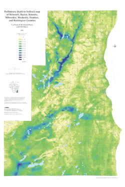
Preliminary Depth to Bedrock Map of Walworth, Racine, Kenosha, Milwaukee, Waukesha, Ozaukee, and Washington Counties
Open-file report; contains unpublished data that has not yet been peer-reviewed.-
Preliminary Depth to Bedrock Map of Walworth, Racine, Kenosha, Milwaukee, Waukesha, Ozaukee, and Washington Counties
2004
Map: 34.75 in x 52 in, scale 1:100,000
-
-
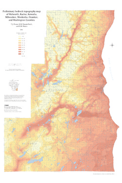
Preliminary Bedrock Topography Map of Walworth, Racine, Kenosha, Milwaukee, Waukesha, Ozaukee, and Washington Counties
Open-file report; contains unpublished data that has not yet been peer-reviewed.-
Preliminary Bedrock Topography Map of Walworth, Racine, Kenosha, Milwaukee, Waukesha, Ozaukee, and Washington Counties
2004
Map: 34.75 in x 52 in, scale 1:100,000
-
-
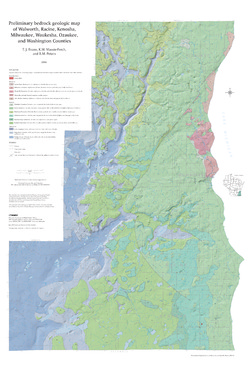
Preliminary Bedrock Geologic Map of Walworth, Racine, Kenosha, Milwaukee, Waukesha, Ozaukee, and Washington Counties
Open-file report; contains unpublished data that has not yet been peer-reviewed.-
Preliminary Bedrock Geologic Map of Walworth, Racine, Kenosha, Milwaukee, Waukesha, Ozaukee, and Washington Counties
2004
Map: 34.75 in x 52 in, scale 1:100,000
-
Preliminary Bedrock Geologic Map of Walworth, Racine, Kenosha, Milwaukee, Waukesha, Ozaukee, and Washington Counties [GIS data]
2004
GIS Data: GeMS file geodatabase (.gdb file format)
-
-
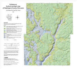
Preliminary Bedrock Geology of Washington County, Wisconsin
Open-file report; contains unpublished data that has not yet been peer-reviewed.-
Preliminary Bedrock Geologic Map of Washington County, Wisconsin
2004
Map: 19 in x 17 in, scale 1:100,000
-
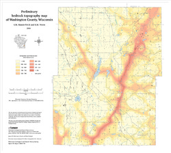
Preliminary Bedrock Topography Map of Washington County, Wisconsin
2004
Map: 19 in x 17 in,scale 1:100,000
-
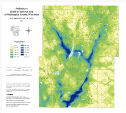
Preliminary Depth to Bedrock Map of Washington County, Wisconsin
2004
Map: 19 in x 17 in, scale 1:100,000
-
-
Summary of Properties of Basal Till in Ozaukee and Washington Counties, Wisconsin
Open-file report; contains unpublished data that has not yet been peer-reviewed. -
Merging Pleistocene Lithostratigraphy with Geotechnical and Hydrogeologic Data--Examples from Eastern Wisconsin
Open-file report; contains unpublished data that has not yet been peer-reviewed. -
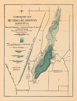
Hydrographic Map of Big Cedar Lake, Washington County
-
Hydrographic Map of Big Cedar Lake, Wisconsin, Washington County
1899
Map: 15 in x 19.9 in, scale 1 in = 1/4 mile
-
-
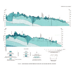
A Subsurface Study of the St. Peter Sandstone in Southern and Eastern Wisconsin
-
Structure Contour Map of the Pre-St. Peter Sandstone Erosion Surface in Southern and Eastern Wisconsin [plate 1]
1985
Map: 39.7 in x 23.5 in, scale 1:750,000
-
Paleogeologic Map of the Pre-St. Peter Sandstone Surface in Southern and Eastern Wisconsin & Thickness Map of the St. Peter Sandstone in Southern and Eastern Wisconsin [plate 2]
1985
Map: 39.4 in x 23.6 in, scale 1:750,000
-
Ground-Water Resources and Geology of Washington and Ozaukee Counties, Wisconsin
-
Geohydrologic Sections Through Washington and Ozaukee Counties, Wisconsin [plate 1]
1980
Plate: 19 in x 16 in
-
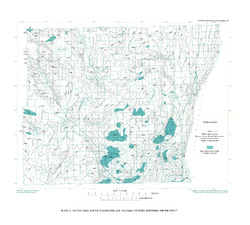
Water-Table Map of Washington and Ozaukee Counties, Wisconsin, Winter 1976-77
1980
Map: 20 in x 18 in, scale 1:125,000
-
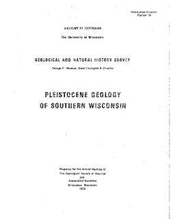
Pleistocene Geology of Southern Wisconsin
Field trip guide with special papers by R.F. Black, N.K. Bleuer, F.D. Hole, N.P. Lasca, and L.J. Maher, Jr., 1970, 175 p. -
Geoscience Wisconsin Volume 17
-
Paleoecology and Sedimentology of the Prasopora Zonule in the Dunleith Formation (Ordovician), Upper Mississippi Valley
2007
Journal Article: p. 11-20
-
Trace-Element Signatures and Tectonic Affinities of Proterozoic A-Type Granites and Rhyolites in Central Wisconsin
2007
Journal Article: p. 35-51
-
Coupled Modeling of Gravity and Aeromagnetic Data to Estimate Subsurface Basement Topography in Southeastern Wisconsin
2007
Journal Article: p. 53-64
-
Geoscience Wisconsin Volume 16
-
Carbonate Diagenesis and Dolomitization of the Lower Ordovician Prairie du Chien Group
1997
Journal Article: p. 1-16
-
Authigenic Silica Fabrics Associated with Cambro-Ordovician Unconformities in the Upper Midwest
1997
Journal Article: p. 25-36
-
Proposed Reference Sections and Correlation of Upper Silurian and Devonian Strata, Eastern Wisconsin
1997
Journal Article: p. 37-46
-
Radon Emanation from Soil of Kenosha, Racine and Waukesha Counties, Southeastern Wisconsin
1997
Journal Article: p. 55-62
-
Geoscience Wisconsin Volume 14
Ordovician-Silurian boundary of the Neda Formation-
Ferruginous and Calcareous Oolites at the Ordovician-Silurian Boundary in Illinois
1991
Journal Article: p. 1-21
-
Paleomagnetic Studies of Rock at the Ordovician-Silurian Boundary in Wisconsin
1991
Journal Article: p. 53-63
-
Distribution and Age of Dolomitic and Hematitic Oolites near the Ordovician-Silurian Boundary in Nebraska and Kansas
1991
Journal Article: p. 65-72

Publications Catalog
Wisconsin Geological and Natural History Survey