
Ground-Water Resources and Geology of Washington and Ozaukee Counties, Wisconsin
Data and Resources
-
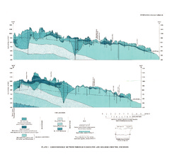
Geohydrologic Sections Through Washington and Ozaukee Counties, Wisconsin [plate 1]
1980
Plate: 19 in x 16 in
-
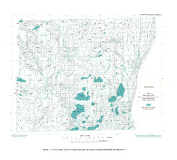
Water-Table Map of Washington and Ozaukee Counties, Wisconsin, Winter 1976-77
1980
Map: 20 in x 18 in, scale 1:125,000
Related Collections
-

Information Circular
View Information Circular