-
Geologic Map of the Fennimore and Mount Hope 7.5-Minute Quadrangles, Grant County, Wisconsin
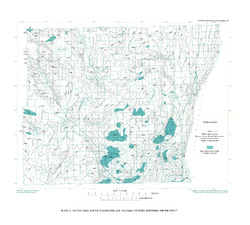
The geologic map of the Fennimore and Mount Hope quadrangles includes 1:24,000-scale mapping of both surficial and bedrock geology. The mapping was initiated to support groundwater studies in the area. The map and accompanying report present the Paleozoic bedrock stratigraphy, including structures, as well as data from three new bedrock drill cores...-
Geologic Map of the Fennimore and Mount Hope 7.5-Minute Quadrangles, Grant County, Wisconsin
2023
Map: 53 in x 36 in, scale 1:24,000
-
Geologic Log Data for the Geologic Map of the Fennimore and Mount Hope 7.5-Minute Quadrangles, Grant County, Wisconsin [dataset 1]
2023
Data: Spreadsheets (.xlsx file format)
-
GIS Data for the Geologic Map of the Fennimore and Mount Hope 7.5-Minute Quadrangles, Grant County, Wisconsin [dataset 2]
2023
GIS Data: GeMS Level 1 file geodatabase (.gdb file format)
-
-
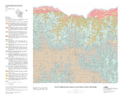
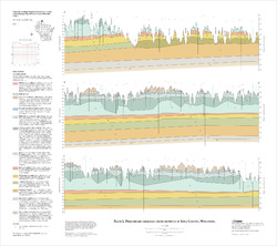
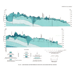
Geologic map of the Stitzer and western part of the Montfort 7.5-minute quadrangles, Grant County, Wisconsin
The geologic map of the Stitzer and western part of the Montfort quadrangles includes 1:24,000-scale mapping of both surficial and bedrock geology. This area occurs at the northern margin of the historic Upper Mississippi Valley lead and zinc mining district. Paleozoic strata are folded into a regionally-significant anticline, and mapping was initiated to...-
Geologic map of the Stitzer and western part of the Montfort 7.5-minute quadrangles, Grant County, Wisconsin
2023
Map: 46.15 in x 36 in, scale 1:24,000
-
GIS data for geologic map of the Stitzer and western part of the Montfort 7.5-minute quadrangles, Grant County, Wisconsin [dataset 1]
2023
GIS Data: GeMS Level 3 file geodatabase (.gdb file format), shapefiles (.shp file format)
-
-
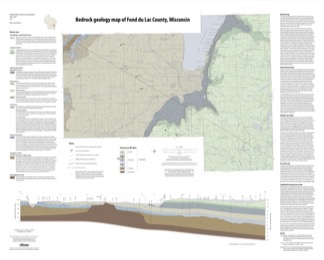
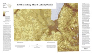
Bedrock Geology of Fond du Lac County, Wisconsin
Two plates showing the bedrock geology and depth to bedrock in Fond du Lac County, Wisconsin. Includes GIS data (shapefiles and grid files).-
GIS Data for the Bedrock Geology of Fond du Lac County, Wisconsin (version 2) [dataset 1]
2018
GIS Data: GeMS file geodatabase (.gdb file format), shapefiles (.shp file format)
-
Bedrock Geology Map of Fond du Lac County, Wisconsin [plate 1]
2018
Plate: 35.75 in x 28.75 in, scale 1:100,000
-
Depth to Bedrock Map of Fond du Lac County, Wisconsin [plate 2]
2018
Plate: 33 in x 19.25 in, scale 1:100,000
-
-
Field Trip: Cambrian and Ordovician Stratigraphy of Southwestern Wisconsin
Field trip route and notes looking at Cambrian and Middle Ordovician rocks of southwestern Wisconsin. -
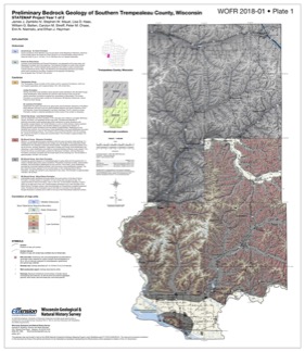
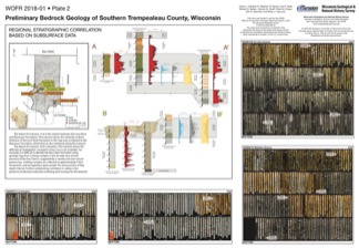
Preliminary Bedrock Geology of Southern Trempealeau County, Wisconsin
This open-file report documents the first year of a two-year mapping project in Trempealeau County, Wisconsin. This preliminary document is being released to encourage input on the mapping methods and map to make the final product as useful as possible. Contains 27-page report, map of southern Trempeleau County, cross section, and photos of drill core.-
Preliminary Bedrock Geology of Southern Trempealeau County, Wisconsin [plate 1]
2018
Plate: 26 in x 29.9 in, scale 1:100,000
-
Preliminary Bedrock Geology of Southern Trempealeau County, Wisconsin [plate 2]
2018
Plate: 35.9 in x 24.9 in
-
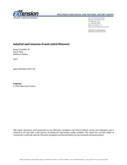
Industrial Sand Resources of West-Central Wisconsin
Field trip guidebook showcasing four sites in Trempealeau County in west-central Wisconsin. The focus of this trip is on the sandstone formations that are prized for frac sand mining. (A draft of this book was originally prepared for the 2017 American Institute of Professional Geologists (AIPG) Sand Mine Life Cycle Seminar held in Eau Claire, Wisconsin.) -
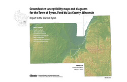
Groundwater Susceptibility Maps, Diagrams, and Report for the Town of Byron, Fond du Lac County, Wisconsin
Open-file report; contains unpublished data that has not yet been peer-reviewed.-
Groundwater Susceptibility Maps and Diagrams for the Town of Byron, Fond du Lac County, Wisconsin
2010
Report: 16 p., 7 plates
-
-
Preliminary Geology of Iowa County, Wisconsin
Open-file report; contains unpublished data that has not yet been peer-reviewed.-
Preliminary Bedrock Geology of Iowa County, Wisconsin (version 2) [GIS data]
2010
GIS Data: GeMS file geodatabase (.gdb file format)
-
Preliminary Geologic Map of Iowa County, Wisconsin [plate 1]
2010
Map: 28 in x 22 in, scale 1:100,000
-
-
Late-Glacial History of East-Central Wisconsin
Open-file report; contains unpublished data that has not yet been peer-reviewed. -
Preliminary Paleozoic Geologic Map of Fond du Lac County, Wisconsin
Open-file report; contains unpublished data that has not yet been peer-reviewed.-
Preliminary Bedrock Geologic Map of Fond du Lac County, Wisconsin [plate 1]
2004
Map: 26 in x 21 in, scale 1:100,000
-
-
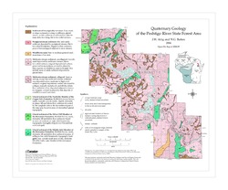
Quaternary Geology of the Peshtigo River State Forest Area
Open-file report; contains unpublished data that has not yet been peer-reviewed. -
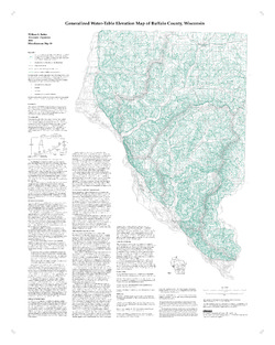
Generalized Water-Table Elevation Map of Buffalo County, Wisconsin
-
Generalized Water-Table Elevation Map of Buffalo County, Wisconsin
2000
Map: 28 in x 35 in, scale 1:100,000
-
-
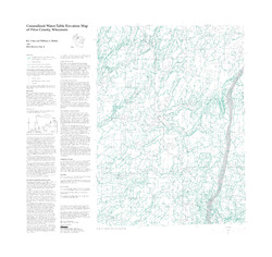
Generalized Water-Table Elevation Map of Price County, Wisconsin
-
Generalized Water-Table Elevation Map of Price County, Wisconsin
1999
Map: 31.5 in x 30 in, scale 1:100,000
-
-
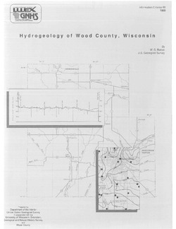
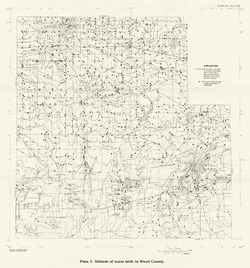
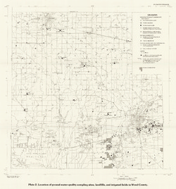
Hydrogeology of Wood County, Wisconsin
-
Location of Ground-Water-Quality Sampling Sites, Landfills, and Irrigated Fields in Wood County [plate 2]
1989
Map: 21.6 in x 23.1 in, scale 1:100,000
-
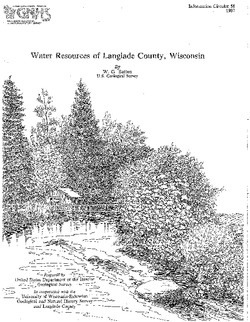
Water Resources of Langlade County, Wisconsin
-
Altitude of Water Table in Langlade, County, Summer 1983 [plate 1]
1987
Map: 26.5 in x 22 in, scale 1:100,000
-
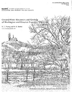
Ground-Water Resources and Geology of Washington and Ozaukee Counties, Wisconsin
-
Geohydrologic Sections Through Washington and Ozaukee Counties, Wisconsin [plate 1]
1980
Plate: 19 in x 16 in
-
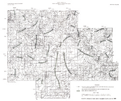
Water-Table Map of Washington and Ozaukee Counties, Wisconsin, Winter 1976-77
1980
Map: 20 in x 18 in, scale 1:125,000

Publications Catalog
Wisconsin Geological and Natural History Survey