-
The Driftless Area: The extent of unglaciated and similar terrains in Wisconsin, Illinois, Iowa, and Minnesota
The Driftless Area of southwestern Wisconsin and northwestern Illinois got its name from the lack of glacial sediment ("drift") covering the landscape. The surficial geology and topography of the Driftless Area are thus distinct from the surrounding region where multiple phases of glaciation left their mark. This pamphlet, a collaborative effort between...-
GIS data for the outline of the Driftless Area and similar terrains in Wisconsin, Illinois, Iowa, and Minnesota
2023
GIS Data: Shapefiles (.shp file format)
-
Page-sized and web-version maps of the Driftless Area and similar terrains in Wisconsin, Illinois, Iowa, and Minnesota
2023
Map: Documents (.pdf file format), images (.tif file format)
-
Wisconsin Groundwater-Level Monitoring Network Improvements, 2018-2021
This report documents work completed as part of a grant from the U.S. Geological Survey’s National Groundwater Monitoring Network (NGWMN) program. It provides an overview of the Wisconsin Groundwater-Level Monitoring Network (WGLMN) and provides detailed description of well evaluation and repair activities, and drilling of new monitoring wells across the... -
Geochemistry and Mineralogy of the Wonewoc-Tunnel City Contact Interval Strata in Western Wisconsin
Results of regional study characterizing the elemental composition of rocks found at the Wonewoc-Tunnel City contact interval in west-central and southwest Wisconsin.-
Geochemistry and Mineralogy of the Wonewoc-Tunnel City Contact Interval Strata in Western Wisconsin [appendices]
2019
Data: Documents (.pdf file format), spreadsheets (.xlsx file format)
-
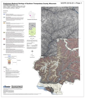
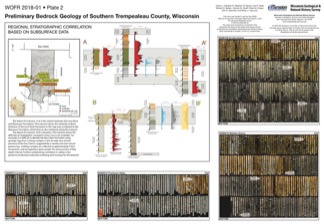
Preliminary Bedrock Geology of Southern Trempealeau County, Wisconsin
This open-file report documents the first year of a two-year mapping project in Trempealeau County, Wisconsin. This preliminary document is being released to encourage input on the mapping methods and map to make the final product as useful as possible. Contains 27-page report, map of southern Trempeleau County, cross section, and photos of drill core.-
Preliminary Bedrock Geology of Southern Trempealeau County, Wisconsin [plate 1]
2018
Plate: 26 in x 29.9 in, scale 1:100,000
-
Preliminary Bedrock Geology of Southern Trempealeau County, Wisconsin [plate 2]
2018
Plate: 35.9 in x 24.9 in
-
Industrial Sand Resources of West-Central Wisconsin
Field trip guidebook showcasing four sites in Trempealeau County in west-central Wisconsin. The focus of this trip is on the sandstone formations that are prized for frac sand mining. (A draft of this book was originally prepared for the 2017 American Institute of Professional Geologists (AIPG) Sand Mine Life Cycle Seminar held in Eau Claire, Wisconsin.) -
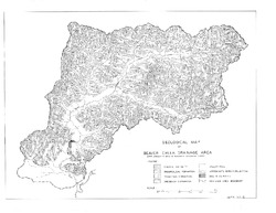
Geological Map of Beaver Creek Drainage Area
Open-file report; contains unpublished data that has not yet been peer-reviewed. -
Discussion of the Phenomena of Local Glaciation in the Driftless Region
Open-file report; contains unpublished data that has not yet been peer-reviewed. -
Studies in the Driftless Region of Wisconsin
Open-file report; contains unpublished data that has not yet been peer-reviewed. -
Geology of Wisconsin - Outcrop Descriptions
These descriptions illustrate various geologic formations, features, and characteristics. Individual descriptions are one to ten pages long, and include a map with specific location, a description of geologic features, and a discussion of the geologic significance.-
Adams County: Upper Wisconsin Dells (T14N R6E Sec28)
Report: 3 p.
-
Adams County: Friendship Mound (T17N R6E Sec5)
Report: 2 p.
-
Adams County: Hamilton Mound (T20N R6E Sec36)
Report: 4 p.
-
Ashland County: Mt. Whittelsey (T44N R2W Sec9A)
Report: 3 p.
-
Ashland County: Mellen Gabbro (T45N R2W Sec30)
Report: 3 p.
-
Ashland County: Mellen Granite (T45N R2W Sec31)
Report: 3 p.
-
Ashland County: White River (T46N R4W Sec6)
Report: 2 p.
-
Bayfield County: South Fish Creek (T47N R5W Sec20)
Report: 2 p.
- 123 more...
-
-
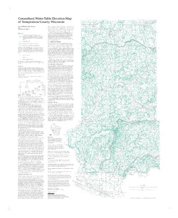
Generalized Water-Table Elevation Map of Trempealeau County, Wisconsin
-
Generalized Water-Table Elevation Map of Trempealeau County, Wisconsin
1998
Map: 27 in x 33 in, scale 1:100,000
-
Generalized Water-Table Elevation Map of Trempealeau County, Wisconsin" [GIS data]
1998
Map: Coverage (.e00 file format)
-
-
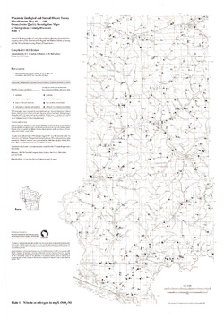
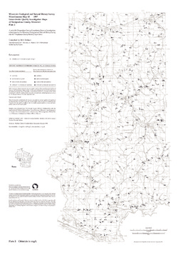
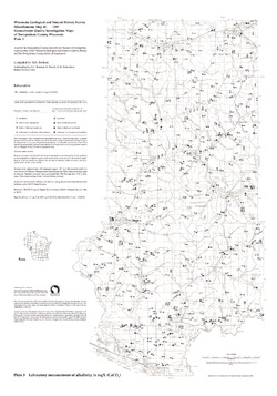
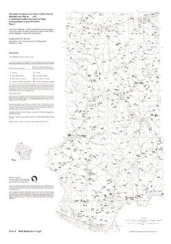
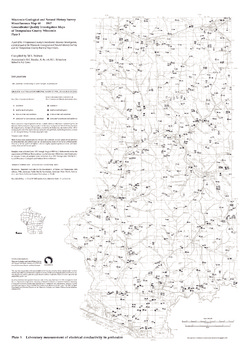
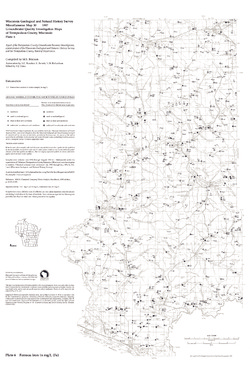
Groundwater Quality Investigation Maps of Trempealeau County, Wisconsin
Includes Plate 1: Nitrate as Nitrogen in mg/L. Plate 2: Chloride in mg/L. Plate 3: Laboratory Measurement of Alkalinity in mg/L. Plate 4: Total Hardness in mg/L. Plate 5: Laboratory Measurement of Electrical Conductivity in μmhos/cm. Plate 6: Ferrous Iron in mg/L.-
Groundwater Quality Investigation Maps of Trempealeau County, Wisconsin: Nitrate as Nitrogen in mg/L [plate 1]
1997
Map: 21 in x 30 in, scale 1:100,000
-
Groundwater Quality Investigation Maps of Trempealeau County, Wisconsin: Chloride in mg/L [plate 2]
1997
Map: 21 in x 30 in, scale 1:100,000
-
Groundwater Quality Investigation Maps of Trempealeau County, Wisconsin: Laboratory Measurement of Alkalinity in mg/L [plate 3]
1997
Map: 21 in x 30 in, scale 1:100,000
-
Groundwater Quality Investigation Maps of Trempealeau County, Wisconsin: Total Hardness in mg/L [plate 4]
1997
Map: 21 in x 30 in, scale 1:100,000
-
Groundwater Quality Investigation Maps of Trempealeau County, Wisconsin: Laboratory Measurement of Electrical Conductivity in μmhos/cm [plate 5]
1997
Map: 21 in x 30 in, scale 1:100,000
-
Groundwater Quality Investigation Maps of Trempealeau County, Wisconsin: Ferrous Iron in mg/L [plate 6]
1997
Map: 20 in x 30 in, scale 1:100,000
-
-
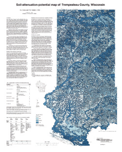
Soil-Attenuation-Potential Map of Trempealeau County, Wisconsin
-
Soil-Attenuation-Potential Map of Trempealeau County, Wisconsin
1993
Map: 24 in x 30 in, scale 1:100,000
-
-
Bedrock Geology of Wisconsin, West-Central Sheet
Types of bedrock, formation names, major faults, and time period of formation.-
Bedrock Geology of Wisconsin, West-Central Sheet [GIS data]
1988
GIS Data: GeMS file geodatabase (.gdb file format)
-
Field Trip Guidebook for Cambrian-Ordovician Geology of Western Wisconsin
With special papers: Lithologic Cycles in Lower Paleozoic Rocks of Western Wisconsin, M.E. Ostrom; and Lithostratigraphy of the Prairie du Chien Group, R.A. Davis, Jr. -
Cambrian Stratigraphy in Western Wisconsin
Notes accompanying a 1966 conference field trip covering geology between Chippewa Falls and Trempealeau and between Elroy and Portage. Routes shown. -
Atlas of the Geological Survey of Wisconsin
Collection of most of the plates accompanying Chamberlin's four-volume Geology of Wisconsin: Survey of 1873-1879.-
Atlas of the Geological Survey of Wisconsin: General Geological Map of Wisconsin [plate 1]
1882
Map: 25.5 in x 30.3 in, scale 1 in = 15 miles
-
Atlas of the Geological Survey of Wisconsin: General Map of Quaternary Formations [plate 2]
1882
Map: 28.2 in x 32.4 in
-
Atlas of the Geological Survey of Wisconsin: General Map of Native Vegetation [plate 2A]
1882
Map: 28.2 in x 32.4 in
-
Atlas of the Geological Survey of Wisconsin: General Map of Soils [plate 2B]
1882
Map: 28.2 in x 32.5 in
-
Atlas of the Geological Survey of Wisconsin: Map of Rainfall and Temperature [plate 2C]
1882
Map: 27.7 in x 32.5 in
-
Atlas of the Geological Survey of Wisconsin: Maps of Subsoils and Native Vegetation of Eastern Wisconsin [plate 3]
1877
Map: 27.82 in x 32.17 in, scale 1 in = 12 miles
-
Atlas of the Geological Survey of Wisconsin: Maps of Topography and Quaternary Formations of Eastern Wisconsin [plate 4]
1877
Map: 27.83 in x 32.06 in, scale 1 in = 12 miles
-
Atlas of the Geological Survey of Wisconsin: Geology and Topography of the Lead Region [plate 5]
1877
Map: 27.68 in x 32.18 in
-
Atlas of the Geological Survey of Wisconsin: Geology and Topography of the Lead Region [plate 6]
1877
Map: 23.98 in x 28.94 in
-
Atlas of the Geological Survey of Wisconsin: Geology and Topography of the Lead Region [plate 8]
1877
Map: 24.03 in x 28.38 in
- 32 more...
-

Publications Catalog
Wisconsin Geological and Natural History Survey