-
Depth to Silurian Bedrock in Eastern Wisconsin
Silurian-aged bedrock in eastern Wisconsin is shallow, fractured, and contains groundwater that is susceptible to surface water contamination. Revisions to Wisconsin state rules ATCP50 and NR151 to regulate manure spreading over this Silurian-aged bedrock create the need for a depth-to-bedrock map of eastern WI. The Wisconsin Geological and Natural...-
Depth to Silurian Bedrock in Eastern Wisconsin [dataset 1]
2025
GIS Data: File geodatabase (.gdb file format)
-
-
Wisconsin Groundwater-Level Monitoring Network Improvements, 2018-2021
This report documents work completed as part of a grant from the U.S. Geological Survey’s National Groundwater Monitoring Network (NGWMN) program. It provides an overview of the Wisconsin Groundwater-Level Monitoring Network (WGLMN) and provides detailed description of well evaluation and repair activities, and drilling of new monitoring wells across the... -
Wisconsin Groundwater-Level Monitoring Network Improvement
The Wisconsin Groundwater-Level Monitoring Network consists of 93 wells and 2 spring gaging stations. This report documents work performed on seven of the wells between August 1, 2016 and July 31, 2017, and appendices provide historical reference documents. -
Distributed Temperature Sensing (DTS) as a Hydrostratigraphic Characterization Tool
Open-file report; contains unpublished data that has not yet been peer-reviewed. -
Mechanisms of Groundwater Flow Across the Maquoketa Formation
Open-file report; contains unpublished data that has not yet been peer-reviewed. -
The Waukesha Fault and its Relationship to the Michigan Basin: A Literature Compilation
Open-file report; contains unpublished data that has not yet been peer-reviewed. -
Preliminary Depth to Bedrock Map of Walworth, Racine, Kenosha, Milwaukee, Waukesha, Ozaukee, and Washington Counties
Open-file report; contains unpublished data that has not yet been peer-reviewed.-
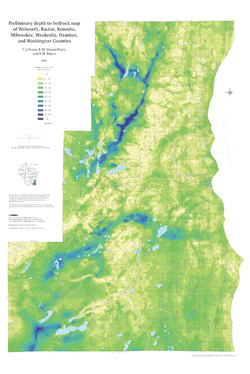
Preliminary Depth to Bedrock Map of Walworth, Racine, Kenosha, Milwaukee, Waukesha, Ozaukee, and Washington Counties
2004
Map: 34.75 in x 52 in, scale 1:100,000
-
-
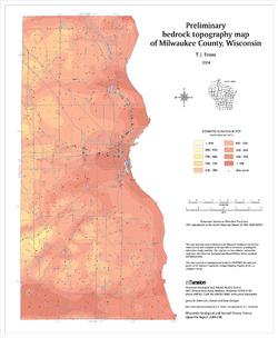
Preliminary Bedrock Topography Map of Walworth, Racine, Kenosha, Milwaukee, Waukesha, Ozaukee, and Washington Counties
Open-file report; contains unpublished data that has not yet been peer-reviewed.-
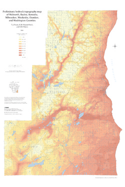
Preliminary Bedrock Topography Map of Walworth, Racine, Kenosha, Milwaukee, Waukesha, Ozaukee, and Washington Counties
2004
Map: 34.75 in x 52 in, scale 1:100,000
-
-
Preliminary Bedrock Geologic Map of Walworth, Racine, Kenosha, Milwaukee, Waukesha, Ozaukee, and Washington Counties
Open-file report; contains unpublished data that has not yet been peer-reviewed.-
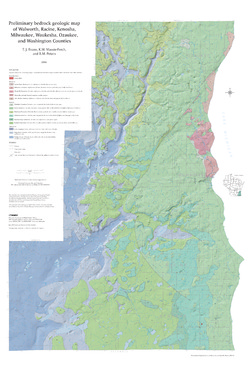
Preliminary Bedrock Geologic Map of Walworth, Racine, Kenosha, Milwaukee, Waukesha, Ozaukee, and Washington Counties
2004
Map: 34.75 in x 52 in, scale 1:100,000
-
Preliminary Bedrock Geologic Map of Walworth, Racine, Kenosha, Milwaukee, Waukesha, Ozaukee, and Washington Counties [GIS data]
2004
GIS Data: GeMS file geodatabase (.gdb file format)
-
-
Preliminary Bedrock Geology of Milwaukee County, Wisconsin
Open-file report; contains unpublished data that has not yet been peer-reviewed.-
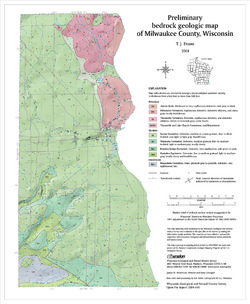
Preliminary Bedrock Geologic Map of Milwaukee County, Wisconsin
2004
Map: 14 in x 17 in, scale 1:100,000
-
Preliminary Bedrock Topography Map of Milwaukee County, Wisconsin
2004
Map: 14 in x 17 in, scale 1:100,000
-
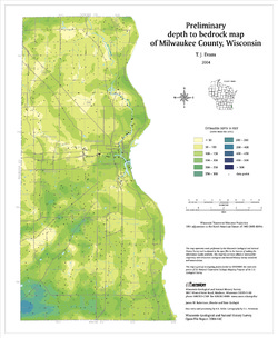
Preliminary Depth to Bedrock Map of Milwaukee County, Wisconsin
2004
Map: 14 in x 17 in, scale 1:100,000
-
-
Merging Pleistocene Lithostratigraphy with Geotechnical and Hydrogeologic Data--Examples from Eastern Wisconsin
Open-file report; contains unpublished data that has not yet been peer-reviewed. -
Geologic Logs from Milwaukee County, Wisconsin
Open-file report; contains unpublished data that has not yet been peer-reviewed. -
A Geological Reconnaissance of Bender County Park, Milwaukee County, Wisconsin
Open-file report; contains unpublished data that has not yet been peer-reviewed. -
Fault on Property of Mr. Harry Grant in Whitefish Bay
Open-file report; contains unpublished data that has not yet been peer-reviewed. -
Geology of Wisconsin - Outcrop Descriptions
These descriptions illustrate various geologic formations, features, and characteristics. Individual descriptions are one to ten pages long, and include a map with specific location, a description of geologic features, and a discussion of the geologic significance.-
Adams County: Upper Wisconsin Dells (T14N R6E Sec28)
Report: 3 p.
-
Adams County: Friendship Mound (T17N R6E Sec5)
Report: 2 p.
-
Adams County: Hamilton Mound (T20N R6E Sec36)
Report: 4 p.
-
Ashland County: Mt. Whittelsey (T44N R2W Sec9A)
Report: 3 p.
-
Ashland County: Mellen Gabbro (T45N R2W Sec30)
Report: 3 p.
-
Ashland County: Mellen Granite (T45N R2W Sec31)
Report: 3 p.
-
Ashland County: White River (T46N R4W Sec6)
Report: 2 p.
-
Bayfield County: South Fish Creek (T47N R5W Sec20)
Report: 2 p.
- 123 more...
-
-
A Subsurface Study of the St. Peter Sandstone in Southern and Eastern Wisconsin
-
Structure Contour Map of the Pre-St. Peter Sandstone Erosion Surface in Southern and Eastern Wisconsin [plate 1]
1985
Map: 39.7 in x 23.5 in, scale 1:750,000
-
Paleogeologic Map of the Pre-St. Peter Sandstone Surface in Southern and Eastern Wisconsin & Thickness Map of the St. Peter Sandstone in Southern and Eastern Wisconsin [plate 2]
1985
Map: 39.4 in x 23.6 in, scale 1:750,000
-
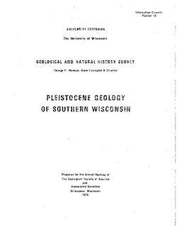
Pleistocene Geology of Southern Wisconsin
Field trip guide with special papers by R.F. Black, N.K. Bleuer, F.D. Hole, N.P. Lasca, and L.J. Maher, Jr., 1970, 175 p.

Publications Catalog
Wisconsin Geological and Natural History Survey