-
Wisconsin Groundwater-Level Monitoring Network Improvements, 2020-2022
This report documents work completed as part of a grant from the U.S. Geological Survey's National Groundwater Monitoring Network (NGWMN) program. It provides an overview of the Wisconsin Groundwater-Level Monitoring Network (WGLMN) and provides detailed description of well evaluation and repair activities, and drilling of new monitoring wells across the... -
Delineation of Zones of Contribution for Municipal Wells in Rock County, Wisconsin: Final Report
Open-file report; contains unpublished data that has not yet been peer-reviewed. -
Aggregate Resources of the Sinnipee Group in Eastern and Southern Wisconsin
Open-file report; contains unpublished data that has not yet been peer-reviewed. -
Rock County Slide Set: What You Should Know About Ground Water and Its Quality
Open-file report; contains unpublished data that has not yet been peer-reviewed. -
A Summary of Geology and Mineral and Water Resources of Rock County
Open-file report; contains unpublished data that has not yet been peer-reviewed. -
A Summary of Geology and Mineral and Water Resources of Rock County
Open-file report; contains unpublished data that has not yet been peer-reviewed. -
A Subsurface Study of the St. Peter Sandstone in Southern and Eastern Wisconsin
-
Structure Contour Map of the Pre-St. Peter Sandstone Erosion Surface in Southern and Eastern Wisconsin [plate 1]
1985
Map: 39.7 in x 23.5 in, scale 1:750,000
-
Paleogeologic Map of the Pre-St. Peter Sandstone Surface in Southern and Eastern Wisconsin & Thickness Map of the St. Peter Sandstone in Southern and Eastern Wisconsin [plate 2]
1985
Map: 39.4 in x 23.6 in, scale 1:750,000
-
Ground-Water Quality of Rock County, Wisconsin
-
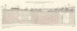
Generalized Geologic Cross Section of Rock County, West-East [plate 1]
1982
Plate: 23.9 in x 9.7 in, scale 1:100,000
-
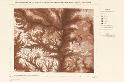
Preliminary Map of the Thickness of Unconsolidated Material in Rock County, Wisconsin [plate 2]
1982
Map: 29.7 in x 19.8 in, scale 1:100,000
-
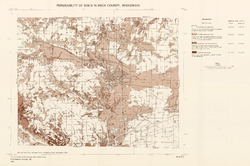
Permeability of Soils in Rock County, Wisconsin [plate 3]
1982
Map: 29.7 in x 19.7 in, scale 1:100,000
-
Pleistocene Geology of Southern Wisconsin
Field trip guide with special papers by R.F. Black, N.K. Bleuer, F.D. Hole, N.P. Lasca, and L.J. Maher, Jr., 1970, 175 p. -
Geoscience Wisconsin Volume 18
History of Wisconsin Geologists-
Chamberlin, Salisbury, and Collie: A Tale of Three Beloit College Geologists
2001
Journal Article: p. 9-20
-
Sequence Stratigraphy at the Turn of the Century: E.O. Ulrich's Ozarkian System in Wisconsin
2001
Journal Article: p. 43-47
- 1 more...
-
Geoscience Wisconsin Volume 08
-
The Pleistocene Stratigraphy and Geomorphology of Central-Southern Wisconsin and Part of Northern Illinois
1983
Journal Article: p. 22-44
-
Geophysical Evidence That the Haeger Till Member Underlies Southern Western Lake Michigan
1983
Journal Article: p. 45-58
-
Geoscience Wisconsin Volume 07
Late Pleistocene History of Southeastern Wisconsin-
Geoscience Wisconsin, Volume 7: Late Pleistocene History of Southeastern Wisconsin
1983
Journal: 111 p.
-
The Wadsworth Till Member of Illinois and the Equivalent Oak Creek Formation of Wisconsin
1983
Journal Article: p. 1-16
-
Quaternary Stratigraphy of the Lower Milwaukee and Menomonee River Valleys, Milwaukee, Wisconsin
1983
Journal Article: p. 24-42
-
The Effect of Lake-Level Fluctuations on the Geomorphic Evolution of the Lake Michigan Bluffs in Wisconsin
1983
Journal Article: p. 43-58
-
Wisconsinan Stratigraphy and Glacial Sequence in Southeastern Wisconsin
1983
Journal Article: p. 59-85
-
Fabric and Depositional Structures in Drumlins near Waukesha, Wisconsin
1983
Journal Article: p. 98-111
-
-
Atlas of the Geological Survey of Wisconsin
Collection of most of the plates accompanying Chamberlin's four-volume Geology of Wisconsin: Survey of 1873-1879.-
Atlas of the Geological Survey of Wisconsin: General Geological Map of Wisconsin [plate 1]
1882
Map: 25.5 in x 30.3 in, scale 1 in = 15 miles
-
Atlas of the Geological Survey of Wisconsin: General Map of Quaternary Formations [plate 2]
1882
Map: 28.2 in x 32.4 in
-
Atlas of the Geological Survey of Wisconsin: General Map of Native Vegetation [plate 2A]
1882
Map: 28.2 in x 32.4 in
-
Atlas of the Geological Survey of Wisconsin: General Map of Soils [plate 2B]
1882
Map: 28.2 in x 32.5 in
-
Atlas of the Geological Survey of Wisconsin: Map of Rainfall and Temperature [plate 2C]
1882
Map: 27.7 in x 32.5 in
-
Atlas of the Geological Survey of Wisconsin: Maps of Subsoils and Native Vegetation of Eastern Wisconsin [plate 3]
1877
Map: 27.82 in x 32.17 in, scale 1 in = 12 miles
-
Atlas of the Geological Survey of Wisconsin: Maps of Topography and Quaternary Formations of Eastern Wisconsin [plate 4]
1877
Map: 27.83 in x 32.06 in, scale 1 in = 12 miles
-
Atlas of the Geological Survey of Wisconsin: Geology and Topography of the Lead Region [plate 5]
1877
Map: 27.68 in x 32.18 in
-
Atlas of the Geological Survey of Wisconsin: Geology and Topography of the Lead Region [plate 6]
1877
Map: 23.98 in x 28.94 in
-
Atlas of the Geological Survey of Wisconsin: Geology and Topography of the Lead Region [plate 8]
1877
Map: 24.03 in x 28.38 in
- 32 more...
-

Publications Catalog
Wisconsin Geological and Natural History Survey