-
Geology of the Baraboo Hills, Sauk and Columbia Counties, Wisconsin
Located in the south-central portion of the state, new geologic mapping of the frequently-visited Baraboo Hills has resulted in a revision of the stratigraphy of the Precambrian-aged bedrock. The Baraboo Quartzite is now divided into four informal members, and the maximum depositional age for the Baraboo Quartzite is 1714±17 million years old. These...-
Geology of the Baraboo Hills, Sauk and Columbia Counties, Wisconsin [plate 1]
2025
Map: 48.25 in x 29.25 in, scale 1:50,000
-
GIS Data for Geology of the Baraboo Hills, Sauk and Columbia Counties, Wisconsin [dataset 1]
2025
GIS Data: GeMS Level 3 file geodatabase (.gdb file format) and GeoPackage (.gpkg file fomat)
-
Geologic Map of the Durwards Glen 7.5-Minute Quadrangle, Columbia and Sauk Counties, Wisconsin
The Durwards Glen 7.5-minute quadrangle map is located in Columbia and Sauk counties, southeast of the city of Baraboo. This geologic map includes Precambrian through Quaternary units. New mapping has focused on subdividing the Baraboo Quartzite into four separate members and delineating Quaternary deposits in greater detail than prior work.-
Geologic Map of the Durwards Glen 7.5-Minute Quadrangle, Columbia and Sauk Counties, Wisconsin
2024
Map: 35 x 40 in, scale 1:24,000
-
GIS Data for the Geologic Map of the Durwards Glen 7.5-Minute Quadrangle, Columbia and Sauk Counties, Wisconsin [dataset 1]
2024
GIS Data: GeMS Level 3 file geodatabase (.gdb file format), shapefiles (.shp file format), GeoPackage (.gpkg file format)
-
-
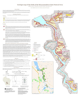
Geologic Map of the Dells of the Wisconsin River State Natural Area
The geologic map of the Dells of the Wisconsin River State Natural Area provides a detailed look at the bedrock geology present at one of Wisconsin's most cherished natural sites. The map and accompanying report present the Paleozoic bedrock stratigraphy of the visible formations, as well as an interpretation of their depositional environment. This map...-
Geologic Map of the Dells of the Wisconsin River State Natural Area
2023
Map: 30 x 36 in, scale 1:12,000
-
-
The Driftless Area: The extent of unglaciated and similar terrains in Wisconsin, Illinois, Iowa, and Minnesota
The Driftless Area of southwestern Wisconsin and northwestern Illinois got its name from the lack of glacial sediment ("drift") covering the landscape. The surficial geology and topography of the Driftless Area are thus distinct from the surrounding region where multiple phases of glaciation left their mark. This pamphlet, a collaborative effort between...-
GIS data for the outline of the Driftless Area and similar terrains in Wisconsin, Illinois, Iowa, and Minnesota
2023
GIS Data: Shapefiles (.shp file format)
-
Page-sized and web-version maps of the Driftless Area and similar terrains in Wisconsin, Illinois, Iowa, and Minnesota
2023
Map: Documents (.pdf file format), images (.tif file format)
-
Elevation contours of the Precambrian surface of south-central Wisconsin
Elevation contour data and an accompanying report provide an updated interpretation of the elevation of the top of Precambrian bedrock in south-central Wisconsin. The elevation surface was developed from geologic and geophysical data, and provides new detail on the entrenched bedrock valleys that were incised into the north and south ranges of the Baraboo...-
Elevation contours of the Precambrian surface of south-central Wisconsin [dataset 1]
2022
GIS Data: File geodatabase (.gdb file format)
-
-
Wisconsin Groundwater-Level Monitoring Network Improvements, 2018-2021
This report documents work completed as part of a grant from the U.S. Geological Survey’s National Groundwater Monitoring Network (NGWMN) program. It provides an overview of the Wisconsin Groundwater-Level Monitoring Network (WGLMN) and provides detailed description of well evaluation and repair activities, and drilling of new monitoring wells across the... -
Applications of the Columbia County, Wisconsin, Groundwater-Flow Model
Computerized groundwater-flow models provide scientific analysis of water resources. Since its initial development in 2014, the Columbia County groundwater-flow model has been used to respond to requests for information about specific groundwater and land use issues. This companion report to the Hydrogeology and simulation of groundwater flow in Columbia... -
Hydrogeology and Simulation of Groundwater Flow in Columbia County, Wisconsin
The WGNHS and the U.S. Geological Survey characterized the hydrogeology and developed a groundwater flow model to assess groundwater resources in Columbia County. This report describes regionally extensive aquifers and presents several extensive datasets collected from deep wells across the county. The report also documents the construction and... -
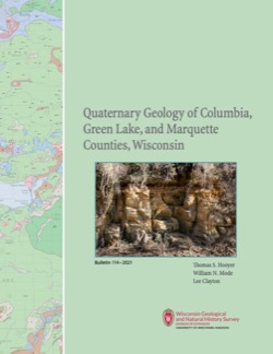
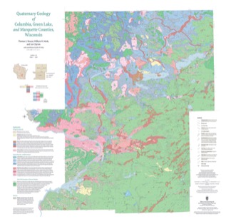
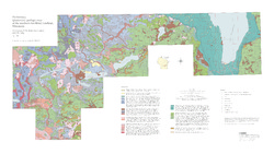
Quaternary Geology of Columbia, Green Lake, and Marquette Counties, Wisconsin
Columbia, Green Lake, and Marquette Counties were glaciated during the last ice age, and large areas were inundated with water from proglacial lakes and large meltwater rivers that occupied the valleys of the existing Wisconsin and Fox Rivers. These processes resulted in rolling upland hills, including drumlins punctuated by low-lying areas dominated by...-
GIS Data for the Quaternary Geology of Columbia, Green Lake, and Marquette Counties, Wisconsin [dataset 1]
2021
GIS Data: GeMS Level 3 file geodatabase (.gdb file format), shapefiles (.shp file format), GeoPackage (.gpkg file format)
-
Quaternary Geology of Columbia, Green Lake, and Marquette Counties, Wisconsin [plate 1]
2021
Map: 35 in x 34 in, scale 1:100,000
-
Geochemistry and Mineralogy of the Wonewoc-Tunnel City Contact Interval Strata in Western Wisconsin
Results of regional study characterizing the elemental composition of rocks found at the Wonewoc-Tunnel City contact interval in west-central and southwest Wisconsin.-
Geochemistry and Mineralogy of the Wonewoc-Tunnel City Contact Interval Strata in Western Wisconsin [appendices]
2019
Data: Documents (.pdf file format), spreadsheets (.xlsx file format)
-
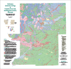
Preliminary Quaternary Geology of Columbia, Green Lake, and Marquette Counties, Wisconsin
This open-file report contains a map (PDF), GIS data (shapefiles), and metadata for Columbia, Green Lake, and Marquette Counties in central Wisconsin.-
Preliminary Quaternary Geology of Columbia, Green Lake, and Marquette Counties, Wisconsin [plate 1]
2015
Map: 35 in x 34 in, scale 1:100,000
-
Preliminary Quaternary Geology of Columbia, Green Lake, and Marquette Counties, Wisconsin [GIS data]
2015
GIS Data: Shapefiles (.shp file format)
-
-
Groundwater Resources of Columbia County, Wisconsin
Three-part series describes the results of a comprehensive inventory and assessment of Columbia County's groundwater resources. Covers water-table elevation, groundwater recharge, and groundwater susceptibility. -
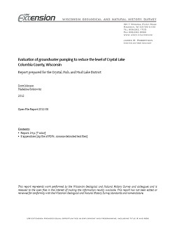
Evaluation of Groundwater Pumping to Reduce the Level of Crystal Lake in Columbia County, Wisconsin
Open-file report; contains unpublished data that has not yet been peer-reviewed.-
Evaluation of Groundwater Pumping to Reduce the Level of Crystal Lake, Columbia County, Wisconsin [appendices]
2012
Data: Documents (.pdf file format), spreadsheets (.csv file format)
-
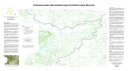
Preliminary Water-Table Elevation Map of Columbia County, Wisconsin
Open-file report; contains unpublished data that has not yet been peer-reviewed.-
Preliminary Water-Table Elevation Map of Columbia County, Wisconsin
2012
Map: 36 in x 20 in, scale 1:100,000
-
Preliminary Water-Table Elevation Map of Columbia County, Wisconsin [GIS data]
2012
GIS Data: Shapefiles (.shp file format)
-
-
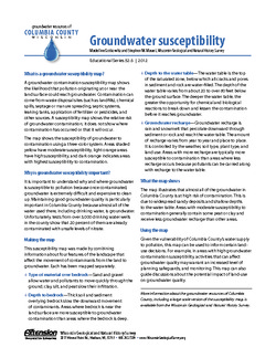
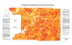
Groundwater Susceptibility Map of Columbia County, Wisconsin
Open-file report; contains unpublished data that has not yet been peer-reviewed.-
Groundwater Susceptibility Map of Columbia County, Wisconsin
2012
Map: 34.5 in x 20.5 in, scale 1:100,000
-
Groundwater Susceptibility Map of Columbia County, Wisconsin [GIS data]
2012
GIS Data: Layer files (.lyr file format), Esri grid files
-
-
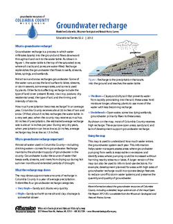
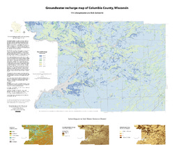
Groundwater Recharge Map of Columbia County, Wisconsin
Open-file report; contains unpublished data that has not yet been peer-reviewed.-
Groundwater Recharge Map of Columbia County, Wisconsin [GIS data]
2012
GIS Data: Layer files (.lyr file format), Esri grid files
-
Preliminary Quaternary Geologic Map of the Southern Fox River Lowland, Wisconsin
Open-file report; contains unpublished data that has not yet been peer-reviewed.-
Preliminary Quaternary Geologic Map of the Southern Fox River Lowland, Wisconsin
2005
Map: 48 in x 27 in, scale 1:100,000
-
-
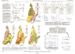
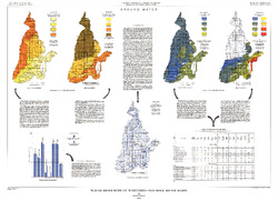
Water Resources of Wisconsin - Rock-Fox River Basin, Hydrologic Investigations Atlas HA-360
-
Water Resources of Wisconsin, Fox-Wolf River Basin: Plate 1, Physical Setting, Water System
1968
Plate: 38 in x 27.25 in
-
Water Resources of Wisconsin, Fox-Wolf River Basin: Plate 2, Ground Water
1968
Plate: 38 in x 27.25 in
-
-
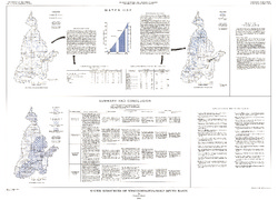
A Subsurface Study of the St. Peter Sandstone in Southern and Eastern Wisconsin
-
Structure Contour Map of the Pre-St. Peter Sandstone Erosion Surface in Southern and Eastern Wisconsin [plate 1]
1985
Map: 39.7 in x 23.5 in, scale 1:750,000
-
Paleogeologic Map of the Pre-St. Peter Sandstone Surface in Southern and Eastern Wisconsin & Thickness Map of the St. Peter Sandstone in Southern and Eastern Wisconsin [plate 2]
1985
Map: 39.4 in x 23.6 in, scale 1:750,000
-
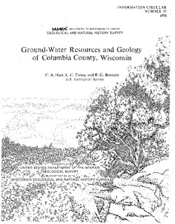
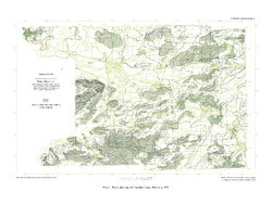
Ground-Water Resources and Geology of Columbia County, Wisconsin
-
Water-Table Map of Columbia County, Wisconsin, 1974 [plate 1]
1978
Map: 24 in x 18 in, scale 1:24,000

Publications Catalog
Wisconsin Geological and Natural History Survey