
Quaternary Geology of Columbia, Green Lake, and Marquette Counties, Wisconsin
Data and Resources
-
GIS Data for the Quaternary Geology of Columbia, Green Lake, and Marquette Counties, Wisconsin [dataset 1]
2021
GIS Data: GeMS Level 3 file geodatabase (.gdb file format), shapefiles (.shp file format), GeoPackage (.gpkg file format)
-
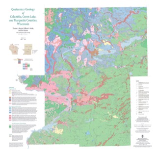
Quaternary Geology of Columbia, Green Lake, and Marquette Counties, Wisconsin [plate 1]
2021
Map: 35 in x 34 in, scale 1:100,000
Related Collections
-

Bulletin
View Bulletin