-
Chequamegon-Nicolet National Forest Water Quality Database
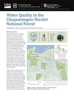
The Chequamegon-Nicolet National Forest (CNNF) in northern Wisconsin contains numerous groundwater-dependent water resources that may be vulnerable to potential effects of land development, mining, and climate change. In order to monitor water quality over time, 138 of the lakes, streams, wetlands, spring ponds, springs, and wells were sampled in...-
Chequamegon-Nicolet National Forest Water Quality Database
2024
Data: Spreadsheets (.csv file format)
-
-
Inventory and Analysis of Flowing Artesian Wells in Bayfield County, Wisconsin
This report presents a county-wide inventory of flowing artesian wells in Bayfield County. Flowing artesian wells are a remarkable resource of high-quality water that both community members and tourists value. This report provides baseline water quality data that are a valuable resource for future assessments. Data collection occurred in 2022. Includes...-
Photos of Flowing Artesian Wells [dataset 2]
2024
Data: Spreadsheets (.csv file format), images (.jpg file format)
-
Geologic Carbon Sequestration: Assessment of Mid-Continent Rift Core Porosities and Permeabilities in Wisconsin
This report presents results from a study investigating the potential for carbon dioxide sequestration in the ancient Keweenawan sedimentary formations in northern Wisconsin. Bedrock drill core from the Copper Harbor and Nonesuch formations were examined for their properties to store carbon dioxide (Copper Harbor) and seal that carbon dioxide (Nonesuch)....-
Data from Geologic Carbon Sequestration: Assessment of Mid-Continent Rift Core Porosities and Permeabilities in Wisconsin [dataset 1]
2023
Data: Spreadsheets (.csv file format)
-
Hydrogeology of the sandy uplands of the Bayfield Peninsula, Wisconsin
The sandy uplands of the Bayfield Peninsula are primary contributors to regional groundwater recharge and provide baseflow to streams in the area. Few data exist, however, to characterize upland hydrogeology or its susceptibility to groundwater contamination. Here, data from two new cores and wells, one existing well, and a lake in the sandy uplands...-
Rotosonic core data from the sandy uplands of the Bayfield Peninsula, Wisconsin [dataset 1]
2022
Data: Spreadsheets (.csv file format)
-
Water-level measurements from two monitoring wells in the sandy uplands of the Bayfield Peninsula, Wisconsin [dataset 2]
2022
Data: Spreadsheets (.csv file format)
-
Potential Effects of Climate Change on Stream Temperature in the Marengo River Headwaters
Cold-water trout habitat in Wisconsin is projected to substantially decrease as a result of climate change. The extent of habitat loss depends, in part, on groundwater discharge to streams, which can provide cool-water refuges for trout. Survey hydrogeologists used field measurements and models of groundwater flow and stream temperature to evaluate how...-
GFLOW Groundwater Flow Model of the Marengo River Headwaters [dataset 1]
2021
Data: Groundwater flow model (.gfl file format), shapefiles (.shp file format)
-
Geodatabase - Three Baseflow Scenarios for the Marengo River Headwaters [dataset 2]
2021
GIS Data: File geodatabase (.gdb file format)
-
Measurements of Water Chemistry, Streamflow, and Stream Temperature from the Marengo River Headwaters [dataset 3]
2021
Data: Spreadsheets (.xlsx file format)
-
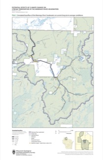
Simulated Baseflow of the Marengo River Headwaters with 21% Increase in Recharge [plate 2]
2021
Map: 11 in x 17 in
-
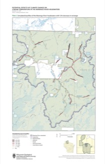
Simulated Baseflow of the Marengo River Headwaters with 12% Decrease in Recharge [plate 3]
2021
Map: 11 in x 17 in
-
Hydrogeologic Atlas of Bayfield County, Wisconsin
Analysis of the groundwater resources in Bayfield County, Wisconsin. Includes report, five plates, and digital data.-
Hydrogeologic Atlas of Bayfield County, Wisconsin [appendices]
2019
Data: Documents (.pdf file format)
-
Hydrogeologic Atlas of Bayfield County, Wisconsin [GIS data]
2019
GIS Data: File geodatabase (.gdb file format)
-
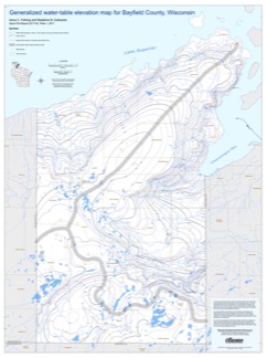
Generalized Water-Table Elevation Map of Bayfield County, Wisconsin [plate 1]
2019
Plate: 29.5 in x 39.5 in, scale 1:100,000
-
Depth to Water Table Map of Bayfield County, Wisconsin [plate 2]
2019
Plate: 29.5 in x 39.5 in, scale 1:100,000
-
Depth to Bedrock Map of Bayfield County, Wisconsin [plate 3]
2019
Plate: 29.5 in x 39.5 in, scale 1:100,000
-
Groundwater Recharge Map of Bayfield County, Wisconsin [plate 4]
2019
Plate: 29.5 in x 39.5 in, scale 1:100,000
-
Groundwater Susceptibility Map of Bayfield County, Wisconsin [plate 5]
2019
Plate: 29.5 in x 39.5 in, scale 1:100,000
-
Characterization of Groundwater Resources in the Chequamegon-Nicolet National Forest, Wisconsin
Results of a comprehensive review and analysis of groundwater resources in the Chequamegon-Nicolet National Forest. The study was divided by location into four reports corresponding to the four main land units: Medford, Nicolet, Park Falls, and Washburn/Great Divide. Each report describes the results of the inventory, modeling, and analysis.-
Characterization of Groundwater Resources in the Chequamegon-Nicolet National Forest, Wisconsin: Medford Unit [GIS data]
2018
GIS Data: File geodatabase (.gdb file format)
-
Characterization of Groundwater Resources in the Chequamegon-Nicolet National Forest, Wisconsin: Medford Unit [plates]
2018
Map: 10 maps, 11 in x 17 in
-
Characterization of Groundwater Resources in the Chequamegon-Nicolet National Forest, Wisconsin: Nicolet Unit [GIS data]
2018
GIS Data: File geodatabase (.gdb file format)
-
Characterization of Groundwater Resources in the Chequamegon-Nicolet National Forest, Wisconsin: Nicolet Unit [plates]
2018
Map: 20 maps (10 each, northern and southern Nicolet Unit), 11 in x 17 in
-
Characterization of Groundwater Resources in the Chequamegon-Nicolet National Forest, Wisconsin: Park Falls Unit [GIS data]
2018
GIS Data: File geodatabase (.gdb file format)
-
Characterization of Groundwater Resources in the Chequamegon-Nicolet National Forest, Wisconsin: Park Falls Unit [plates]
2018
Map: 10 maps, 11 in x 17 in
- 2 more...
-
Bayfield County [Wisconsin] Water-Table Map and Water Well Database
This report provides information about well construction, groundwater flow, and resulting implications for well susceptibility in Bayfield County, Wisconsin. The work follows an earlier groundwater study that focused on two agricultural areas within Bayfield County.-
Generalized Water-Table Elevation Map for Bayfield County, Wisconsin [GIS data]
2017
GIS Data: Shapefiles (.shp file format)
-
Generalized Water-Table Elevation Map for Bayfield County, Wisconsin [plate 1]
2017
Plate: 30 in x 40 in, scale 1:100,000
-
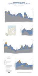
Groundwater and Wells in Agricultural Regions of Bayfield County, Wisconsin: Report to the Large-Scale Livestock Study Committee
Information and recommendations concerning groundwater and water supply wells in two agricultural regions in Bayfield County, Wisconsin. Includes a report, a water-table map, a set of four cross sections, and GIS data. (Replaces WOFR2015-02.)-
Groundwater and Wells in Agricultural Regions of Bayfield County, Wisconsin [GIS data]
2016
GIS Data: Shapefiles (.shp file format)
-
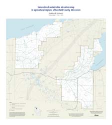
Generalized Water-Table Elevation Map in Agricultural Regions of Bayfield County, Wisconsin [plate 1]
2016
Map: 27 in x 30 in, scale 1:100,000
-
Hydrogeologic Cross Sections in Agricultural Regions of Bayfield County, Wisconsin [plate 2]
2016
Plate: 20 in x 40 in, scale 1:100,000
-
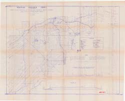
Summary of Field Mapping in the Superior Map Sheet, Wisconsin
Open-file report; contains unpublished data that has not yet been peer-reviewed. -
Geologic Summary of the Ashland 2° Quadrangle
Open-file report; contains unpublished data that has not yet been peer-reviewed.-
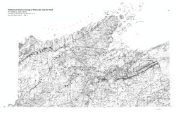
Preliminary Bedrock Geologic Map: Ashland Quadrangle
1979
Map: 4 p., 1 plate, 29.22 in x 25.65 in, scale 1:250,000
-
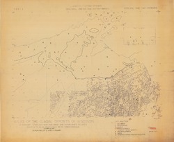
Copper Bearing Formations of Douglas and Northwest Bayfield Counties
Open-file report; contains unpublished data that has not yet been peer-reviewed.-
Copper Bearing Formations of Douglas and Northwest Bayfield Counties
1928
Map: 52.2 in x 42.4 in, scale 1 in = 1 mile
-
-
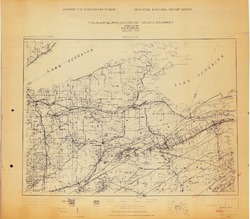
Copper Bearing Formations of Bayfield and Southeast Douglas Counties
Open-file report; contains unpublished data that has not yet been peer-reviewed.-
Copper Bearing Formations of Bayfield and Southeast Douglas Counties
1928
Map: 38.3 in x 22.1 in, scale 1 in = 1 mile
-
-
Geology of Wisconsin - Outcrop Descriptions
These descriptions illustrate various geologic formations, features, and characteristics. Individual descriptions are one to ten pages long, and include a map with specific location, a description of geologic features, and a discussion of the geologic significance.-
Adams County: Upper Wisconsin Dells (T14N R6E Sec28)
Report: 3 p.
-
Adams County: Friendship Mound (T17N R6E Sec5)
Report: 2 p.
-
Adams County: Hamilton Mound (T20N R6E Sec36)
Report: 4 p.
-
Ashland County: Mt. Whittelsey (T44N R2W Sec9A)
Report: 3 p.
-
Ashland County: Mellen Gabbro (T45N R2W Sec30)
Report: 3 p.
-
Ashland County: Mellen Granite (T45N R2W Sec31)
Report: 3 p.
-
Ashland County: White River (T46N R4W Sec6)
Report: 2 p.
-
Bayfield County: South Fish Creek (T47N R5W Sec20)
Report: 2 p.
- 123 more...
-
-
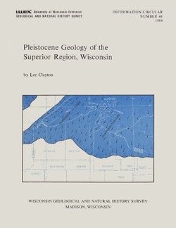
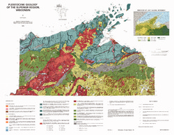
Pleistocene Geology of the Superior Region, Wisconsin
-
Pleistocene Geology of the Superior Region, Wisconsin (version 2) [GIS data]
1985
GIS Data: GeMS Level 3 file geodatabase (.gdb file format)
-
Pleistocene Geology of the Superior Region, Wisconsin [plate 1]
1985
Map: 35.9 in x 27.8 in, scale 1:250,000
-
Geoscience Wisconsin Volume 09
-
The Geology of the Lower Proterozoic McCaslin Formation, Northeastern Wisconsin
1984
Journal Article: p. 1-19
-
Stratigraphy and History of Glacial Deposits Along Wisconsin's Lake Superior Shoreline - Wisconsin Point to Bark Point
1984
Journal Article: p. 21-51

Publications Catalog
Wisconsin Geological and Natural History Survey