
Bayfield County [Wisconsin] Water-Table Map and Water Well Database
Data and Resources
-
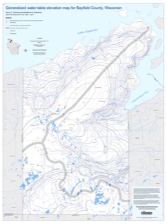
Generalized Water-Table Elevation Map for Bayfield County, Wisconsin [GIS data]
2017
GIS Data: Shapefiles (.shp file format)
-
Generalized Water-Table Elevation Map for Bayfield County, Wisconsin [plate 1]
2017
Plate: 30 in x 40 in, scale 1:100,000
Related Collections
-

Open-File Report
View Open-File Report