-
Wisconsin Groundwater-Level Monitoring Network Improvements, 2022-2024
This report documents work completed as part of a grant from the U.S. Geological Survey's National Groundwater Monitoring Network (NGWMN) program. It provides an overview of the Wisconsin Groundwater-Level Monitoring Network (WGLMN) and provides detailed description of well evaluation and repair activities, and drilling of new monitoring wells across the... -
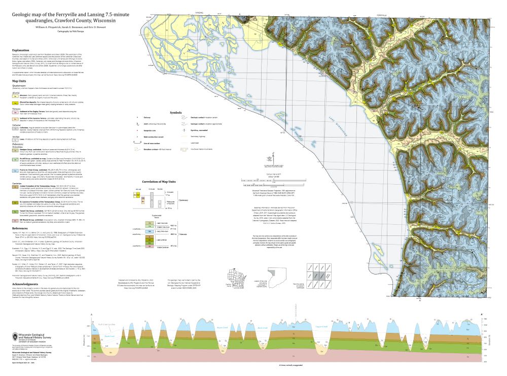
Geologic Map of the Ferryville and Lansing 7.5-Minute Quadrangles, Crawford County, Wisconsin
The geologic map of the Ferryville and Lansing 7.5-minute quadrangles (Crawford County), located in the Driftless Area of southwestern Wisconsin, provides new observations and lithologic descriptions of the area's geology. This work supports the Wisconsin Department of Transportation's ongoing efforts to mitigate slope failures along the Wisconsin State...-
Geologic Map of the Ferryville and Lansing 7.5-Minute Quadrangles, Crawford County, Wisconsin
2025
Map: 41.5 in x 30.75 in, scale 1:24,000
-
GIS Data for the Geologic Map of the Ferryville and Lansing 7.5-Minute Quadrangles, Crawford County, Wisconsin [dataset 1]
2025
GIS Data: GeMS Level 3 file geodatabase (.gdb file format) and GeoPackage (.gpkg file format)
-
-
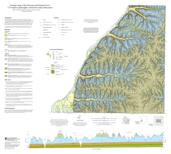
Geologic Map of the Eastman and Harpers Ferry 7.5-Minute Quadrangles, Crawford County, Wisconsin
The geologic map of the Eastman and Harpers Ferry 7.5-minute quadrangles (Crawford County), located in the Driftless Area of southwestern Wisconsin, provides new observations and lithologic descriptions of the area's geology. This work supports the Wisconsin Department of Transportation's ongoing efforts to mitigate slope failures along the Wisconsin...-
Geologic Map of the Eastman and Harpers Ferry 7.5-Minute Quadrangles, Crawford County, Wisconsin
2025
Map: 36 in x 32.5 in, scale 1:24,000
-
GIS Data for the Geologic Map of the Eastman and Harpers Ferry 7.5-Minute Quadrangles, Crawford County, Wisconsin [dataset 1]
2025
GIS Data: GeMS Level 3 file geodatabase (.gdb file format) and GeoPackage (.gpkg file format)
-
-
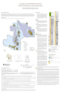
Geologic Map of Mill Bluff State Park, Monroe and Juneau Counties, Wisconsin
The geologic map of the Mill Bluff State Park provides a detailed look at the bedrock geology present at one of Wisconsin's most cherished natural sites. The map and accompanying report present the Paleozoic bedrock stratigraphy of the visible formations, as well as an interpretation of their depositional environment. This map was created as part of an...-
Geologic Map of Mill Bluff State Park, Monroe and Juneau Counties, Wisconsin
2024
Map: 24 x 36 in, scale 1:12,000
-
-
Wisconsin Groundwater-Level Monitoring Network Improvements, 2020-2022
This report documents work completed as part of a grant from the U.S. Geological Survey's National Groundwater Monitoring Network (NGWMN) program. It provides an overview of the Wisconsin Groundwater-Level Monitoring Network (WGLMN) and provides detailed description of well evaluation and repair activities, and drilling of new monitoring wells across the... -
Geologic Map of the Durwards Glen 7.5-Minute Quadrangle, Columbia and Sauk Counties, Wisconsin
The Durwards Glen 7.5-minute quadrangle map is located in Columbia and Sauk counties, southeast of the city of Baraboo. This geologic map includes Precambrian through Quaternary units. New mapping has focused on subdividing the Baraboo Quartzite into four separate members and delineating Quaternary deposits in greater detail than prior work.-
Geologic Map of the Durwards Glen 7.5-Minute Quadrangle, Columbia and Sauk Counties, Wisconsin
2024
Map: 35 x 40 in, scale 1:24,000
-
GIS Data for the Geologic Map of the Durwards Glen 7.5-Minute Quadrangle, Columbia and Sauk Counties, Wisconsin [dataset 1]
2024
GIS Data: GeMS Level 3 file geodatabase (.gdb file format), shapefiles (.shp file format), GeoPackage (.gpkg file format)
-
-
Inventory and Analysis of Flowing Artesian Wells in Bayfield County, Wisconsin
This report presents a county-wide inventory of flowing artesian wells in Bayfield County. Flowing artesian wells are a remarkable resource of high-quality water that both community members and tourists value. This report provides baseline water quality data that are a valuable resource for future assessments. Data collection occurred in 2022. Includes...-
Photos of Flowing Artesian Wells [dataset 2]
2024
Data: Spreadsheets (.csv file format), images (.jpg file format)
-
Geologic Carbon Sequestration: Assessment of Mid-Continent Rift Core Porosities and Permeabilities in Wisconsin
This report presents results from a study investigating the potential for carbon dioxide sequestration in the ancient Keweenawan sedimentary formations in northern Wisconsin. Bedrock drill core from the Copper Harbor and Nonesuch formations were examined for their properties to store carbon dioxide (Copper Harbor) and seal that carbon dioxide (Nonesuch)....-
Data from Geologic Carbon Sequestration: Assessment of Mid-Continent Rift Core Porosities and Permeabilities in Wisconsin [dataset 1]
2023
Data: Spreadsheets (.csv file format)
-
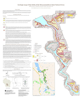
Geologic Map of the Dells of the Wisconsin River State Natural Area
The geologic map of the Dells of the Wisconsin River State Natural Area provides a detailed look at the bedrock geology present at one of Wisconsin's most cherished natural sites. The map and accompanying report present the Paleozoic bedrock stratigraphy of the visible formations, as well as an interpretation of their depositional environment. This map...-
Geologic Map of the Dells of the Wisconsin River State Natural Area
2023
Map: 30 x 36 in, scale 1:12,000
-
-
Geologic Map of the Fennimore and Mount Hope 7.5-Minute Quadrangles, Grant County, Wisconsin
The geologic map of the Fennimore and Mount Hope quadrangles includes 1:24,000-scale mapping of both surficial and bedrock geology. The mapping was initiated to support groundwater studies in the area. The map and accompanying report present the Paleozoic bedrock stratigraphy, including structures, as well as data from three new bedrock drill cores...-
Geologic Map of the Fennimore and Mount Hope 7.5-Minute Quadrangles, Grant County, Wisconsin
2023
Map: 53 in x 36 in, scale 1:24,000
-
Geologic Log Data for the Geologic Map of the Fennimore and Mount Hope 7.5-Minute Quadrangles, Grant County, Wisconsin [dataset 1]
2023
Data: Spreadsheets (.xlsx file format)
-
GIS Data for the Geologic Map of the Fennimore and Mount Hope 7.5-Minute Quadrangles, Grant County, Wisconsin [dataset 2]
2023
GIS Data: GeMS Level 1 file geodatabase (.gdb file format)
-
-
Geologic map of the Stitzer and western part of the Montfort 7.5-minute quadrangles, Grant County, Wisconsin
The geologic map of the Stitzer and western part of the Montfort quadrangles includes 1:24,000-scale mapping of both surficial and bedrock geology. This area occurs at the northern margin of the historic Upper Mississippi Valley lead and zinc mining district. Paleozoic strata are folded into a regionally-significant anticline, and mapping was initiated to...-
Geologic map of the Stitzer and western part of the Montfort 7.5-minute quadrangles, Grant County, Wisconsin
2023
Map: 46.15 in x 36 in, scale 1:24,000
-
GIS data for geologic map of the Stitzer and western part of the Montfort 7.5-minute quadrangles, Grant County, Wisconsin [dataset 1]
2023
GIS Data: GeMS Level 3 file geodatabase (.gdb file format), shapefiles (.shp file format)
-
-
Assessing private well contamination in Grant, Iowa, and Lafayette counties: The southwest Wisconsin groundwater and geology study
The southwest Wisconsin groundwater and geology study (SWIGG) was a cooperative effort between Grant, Iowa, and Lafayette county governments, with scientists from the U.S. Geological Survey, U.S. Department of Agriculture, Marshfield Clinic Research Institute, and WGNHS. Researchers tested water quality in hundreds of private water wells across the three... -
Evaluating pXRF instrument performance using reference materials
The portable X-Ray Fluorescence (pXRF) instrument provides fast, real-time, non-destructive, multi-element geochemical data (i.e. elemental concentrations) on rocks and minerals at a relatively low cost and with minimal sample preparation. This study quantifies the precision and accuracy of measurements collected by the WGNHS pXRF on reference materials... -
Hydrogeology of the sandy uplands of the Bayfield Peninsula, Wisconsin
The sandy uplands of the Bayfield Peninsula are primary contributors to regional groundwater recharge and provide baseflow to streams in the area. Few data exist, however, to characterize upland hydrogeology or its susceptibility to groundwater contamination. Here, data from two new cores and wells, one existing well, and a lake in the sandy uplands...-
Rotosonic core data from the sandy uplands of the Bayfield Peninsula, Wisconsin [dataset 1]
2022
Data: Spreadsheets (.csv file format)
-
Water-level measurements from two monitoring wells in the sandy uplands of the Bayfield Peninsula, Wisconsin [dataset 2]
2022
Data: Spreadsheets (.csv file format)
-
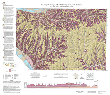
Geologic map of the Bloomington and Brodtville 7.5-minute quadrangles, Grant County, Wisconsin
The geologic map of the Bloomington and Brodtville quadrangles includes 1:24,000 scale mapping of both surficial and bedrock geology. There is little structural folding or faulting in this portion of the Driftless Area. Thus, it is ideal for studying the hydrostratigraphic framework of the mapped units. The accompanying report presents stratigraphic...-
Geologic map of the Bloomington and Brodtville 7.5-minute quadrangles, Grant County, Wisconsin
2022
Map: 41 in x 35 in, scale 1:24,000
-
GIS data for the geologic map of the Bloomington and Brodtville 7.5-minute quadrangles, Grant County, Wisconsin [dataset 1]
2022
GIS Data: File geodatabase (.gdb file format)
-
-
Wisconsin Groundwater-Level Monitoring Network Improvements, 2018-2021
This report documents work completed as part of a grant from the U.S. Geological Survey’s National Groundwater Monitoring Network (NGWMN) program. It provides an overview of the Wisconsin Groundwater-Level Monitoring Network (WGLMN) and provides detailed description of well evaluation and repair activities, and drilling of new monitoring wells across the... -
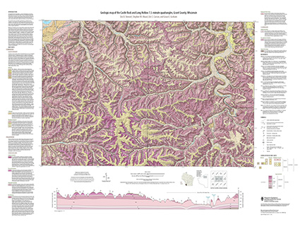
Geologic map of the Castle Rock and Long Hollow 7.5-minute quadrangles, Grant County, Wisconsin
The geologic map of the Castle Rock and Long Hollow quadrangles includes 1:24,000 scale mapping of both surficial and bedrock geology. The accompanying report presents new observations about bedrock folds and fracture sets in this portion of the Driftless Area that lies just north of the main Upper Mississippi Valley zinc-lead mineral district. The...-
Geologic map of the Castle Rock and Long Hollow 7.5-minute quadrangles, Grant County, Wisconsin (revised 2022)
2022
Map: 48 in x 36 in, scale 1:24,000
-
GIS data for the geologic map of the Castle Rock and Long Hollow 7.5-minute quadrangles, Grant County, Wisconsin [dataset 1]
2022
GIS Data: File geodatabase (.gdb file format)
-
-
Applications of the Columbia County, Wisconsin, Groundwater-Flow Model
Computerized groundwater-flow models provide scientific analysis of water resources. Since its initial development in 2014, the Columbia County groundwater-flow model has been used to respond to requests for information about specific groundwater and land use issues. This companion report to the Hydrogeology and simulation of groundwater flow in Columbia... -
Mineral Assessments for Conservation Easements in Wisconsin
If you’re thinking about donating land as a conservation easement but don’t own the subsurface (known as “severed mineral rights”), then you’ll need an assessment of the land’s mineral potential to determine whether the easement will qualify as a charitable tax deduction. Geologists at the Wisconsin Geological and Natural History Survey perform this... -
Depth-to-Bedrock Mapping in Wisconsin
Depth-to-bedrock maps show the thickness of unconsolidated materials overlying bedrock. These maps provide a key link between the underlying geology, groundwater flow, and land use and are important in guiding activities such as permitting, bridge construction, and the land application of waste products in sensitive areas. Given their role in guiding...

Publications Catalog
Wisconsin Geological and Natural History Survey